2023:570 - CLONYMEATH, Meath
County: Meath
Site name: CLONYMEATH
Sites and Monuments Record No.: N/A
Licence number: 23E0613
Author: Alan Healy, Archaeological Management Solutions
Author/Organisation Address: Fahy’s Road, Kilrush, Co. Clare, V15 C780
Site type: Excavation - miscellaneous
Period/Dating: Multi-period
ITM: E 685750m, N 750500m
Latitude, Longitude (decimal degrees): 53.497507, -6.707599
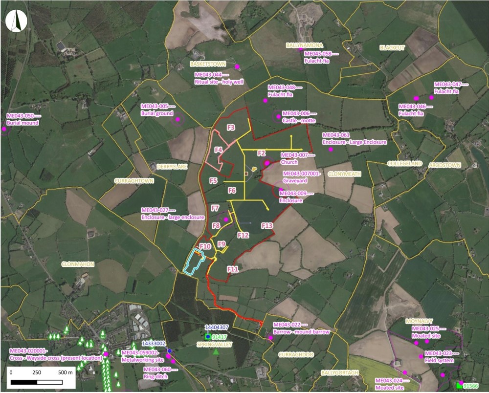
The programme of archaeological testing took place within the townland of Clonymeath, Co. Meath between 31 July and 25 August 2023 over Field 2–Field 13 and along the proposed location of the access track in Field 17–Field 22. A total of 161 test trenches, along with several trench extensions, were excavated at the site, totalling 4,964 linear metres. The objective of the testing was to investigate the potential archaeological features identified by the geophysical survey under licence numbers 21R0250 & 21R0159 while the random test trenches were laid out to cover the rest of the area to ascertain the nature, extent and significance of any additional archaeological features at the site. Each trench measured 1.8m in width and the test trenches were excavated down to the natural subsoil.
While several of the anomalies identified in the geophysical survey turned out to be of geological origin, several areas of archaeological interest were identified. The archaeological features identified throughout the site comprised thirteen burnt spreads/mounds, one kiln, seven curvilinear ditches/slots, 43 linear ditches/slots, 22 pits, ten post-holes, six stake-holes, two deposits, one earthen bank and one metaled surface.
Field 2
Towards the eastern extent of Field 2, near the centre of the field, TT80 targeted a small circular ditched feature that measured c.8m in diameter with a possible entrance way to the north-northwest (CH06). Two curvilinear ditches (C.28 and C.30) representing the eastern and western sides of the feature were recorded, confirming the presence of a possible ring-ditch.
Located in the northern end of Field 2, CH07, CH08, and other nearby linear and rectilinear features were targeted by TT79 and TT80. These features are potentially associated with a seventeenth- and eighteenth-century house and related domestic structures, the presence of which is suggested in the historical record. While four of the linear ditches (C.19, C.26, C.32 and C.34) consisted of generally sterile fills, a possible foundation slot (C.24) could be the remains of a seventeenth-century structure, while the deposit (C.25) could have an association with either phase of activity. The possible foundation slot appeared to have been stripped of materials and was then subsequently packed full of industrial waste material in the form of metal slag.
The remaining linear ditches recorded in Field 2 were located within the postulated Deserted Medieval Settlement (DMV) (CH186). The fills of these linear ditches (C.39, C.41, C.45, C.47, C.49 and C.51) were generally sterile but confirmed the presence of ditches associated with the potential abandoned settlement. Additional linear ditches (C.22 and C.37) were located in Field 2; C.22 to the northeast of the DMV (CH186) and C.37 at the northwestern extent of the potential DMV appeared to be part of a water management or drainage system.
A single pit (C.43) was identified within TT155 and could be associated with activity within the potential settlement. Two pits recorded in TT65 (C.53 and C.55), adjacent to the quarry (CH33), seemed to be more modern in nature and not associated with the postulated DMV.
Field 3
Two areas of archaeology were identified in Field 3, consisting of two burnt spreads (C.4 and C.5) within TT51 (identified as AAP04) and a northwest–southeast orientated linear ditch in TT49 (C.6). C.4 and C.5 could be contemporaneous with the fulacht fiadh (ME043-048) excavated (02E0689) previously to the northeast. C.6 is a drainage ditch running along the northeast base of the northeast bank of a possible hollow-way (CH01) orientated northwest–southeast between Field 3 and Field 4.
Field 4
TT159 and TT160 targeted a possible hollow way (CH15) as noted in the geophysical survey results and the walkover survey. While this is possible, the form of the excavated linear ditches C.10 and C.15 appear to be that of large drainage ditches. TT157 targeted a linear anomaly along the western extent of the potential DMV (CH186; C.17) that also appears to have been for the purposes of drainage or water management.
Field 5
To the western side of Field 5 in TT48, another burnt spread (C.138) was identified. Several of the geophysical anomalies targeted in TT42, TT44 and TT45 were confirmed as linear ditches.**
The interpretation of CH16 as delineating the western extent of the postulated DMV (CH186) may be accurate, as TT42 confirmed the presence of a linear ditch (C.136) with an associated earthen bank (C.135). The three linear ditches (C.143, C.145 and C.147) identified in the northeastern corner of Field 5 could be associated with the linear ditch (C.17) noted in Field 4 and may be part of a drainage or water management system.
TT44 targeted CH17 – noted in the geophysical survey results as a spread of burnt material– and it was here that the richest evidence for activity within the surrounds of the DMV was identified. The central linear slot (C.151) contained a basal fill comprising an ash-rich deposit (C.153), while the charcoal-rich upper fill (C.152) contained the remains of a small mammal. The remaining linear ditches (C.149 and C.154) located on either side of C.151 were generally sterile.
Field 6
Testing in Field 6 revealed evidence for activity that may be associated with the DMV (CH186). Four linear ditches were recorded in TT33 and TT38 along the presumed southern extent of the DMV (C.94, C.96, C.108 and C.112), though the fills were generally sterile. A kiln (C.110) and an alignment of six stakeholes (C.114–C.119) were also noted in TT38, indicating potential auxiliary activity associated with the potential abandoned settlement.
An isolated ditch/slot (C.92) was identified in the northeast of Field 6 in TT35. Medieval ceramic sherds (23E0613:9) (thirteenth–fourteenth century, pers. comm. Elaine Lynch) were retrieved from TT39, confirming medieval activity in the immediate area.
A large ditch (C.139) in TT23 may indicate the remains of a water management system (CH101), while towards the western end of TT23, the remains of a relict field boundary (C.141) would have connected to the remains of a tree line running south from Field 5.
The remaining archaeological features identified in Field 6 were concentrated in the southern section of the field within TT25, TT26, TT29 and TT30 adjacent to Field 13. Identified remains possibly indicate prehistoric activity and include six pits (C.102, C.104, C.123, C.129, C.131 and C.133), a metal working furnace (C.121), a hearth (C.106), posthole (C.120) and two curvilinear slots (C.125 and C.127) that form a possible ring-ditch measuring approximately 5.5m in diameter (identified as AAP16). Two of the pits (C.102 and C.104) are likely associated with activity at the sub-rectangular enclosure (CH14/CH18) split between Fields 6 and 13. Pit C.123 was located directly beside the metal working furnace (C.121) and contained slag. The remaining three pits (C.129, C.131 and C.133) all contained charcoal-enriched soil and heat-shattered stone.
Field 7 and Field 8
No archaeological features were identified within Fields 7 and 8.
Field 9
A single isolated pit (C.156) was identified in the centre of Field 9 within TT118. To the south of the field within TT116, a small burnt spread was identified (C.158). This probable prehistoric activity appears to continue south from Field 6 and Field 13, through Fields 9–12 along the southern portion of the subject site.
Field 10
In the northern section of Field 10, test trenches were set out surrounding a bivallate enclosure (CH23) for the purpose of exploring potentially associated features as determined through the geophysical survey results. Posthole C.198 was recorded in TT8 to the southwest of CH23; the posthole appeared to have been burnt in-situ, with the resultant smouldering collapse forming a deposit of charcoal-enriched and heat-affected soil (C.200). To the north of CH23, a single pit (C.201) was identified within TT6, while one pit (C.203), a burnt spread (C.207) comprising heat-affected stone, as well as two linear ditches (C.205 and C.208) were identified in TT4 situated along the proposed access track. Linear ditch C.205 cut the burnt spread (C.207) and continued past linear ditch C.208 – a large ditch at the northern base of a large bank to the south. It was not possible to fully define C.208 or its relationship with C.205 as the base of this trench became flooded.
The linear ditch (C.196) in TT1 to the southeast of the field could be a drainage ditch or have an association with the other archaeological features in the vicinity.
Considering the archaeological features surrounding CH23, it could be suggested that the bivallate enclosure has prehistoric origins.
Field 11
Two potential charcoal production pits (C.178 and C.181) are located near the northern boundary of Field 11 within TT149 and TT150, respectively. To the south-southwest of the charcoal production pits, the faint evidence of an enclosing ditch (CH26), located on a natural rise within the centre of the field, was identified in the northwest section of TT151 as a linear ditch (C.194). A second linear ditch (C.190) was recorded in the southeast portion of the trench; however, it is considered to be a drainage ditch and not associated with archaeological activity in the area. Three postholes (C.184, C.186, and C.188) and a pit (C.192) were also identified in TT151 within the potential enclosure.
A linear ditch (C.210) was identified in TT129 along the location of the proposed access track (Figure 14a). A flint flake (23E0613:11) was recovered directly adjacent to the ditch in the spoil excavated from the trench.
It could be suggested that the pit cluster (CH27) south of CH26/TT151 could be an area of potential metal working features, due to the charcoal production pits recorded just to the north in TT149 and TT150.
Field 12
Two small burnt spreads (C.176 and C.177) were identified within TT121 to the west and TT125 to the south of Field 12. To the north in TT120 (at AAP29), a larger burnt spread (C.159) was identified accompanied by three postholes (C.166, C.168 and C.170), a linear ditch (C.160) and a linear slot (C.162); both containing occasional heat-shattered stone. A curvilinear slot (C.164) orientated southeast–northwest to northeast–southwest represents the remains of a possible structural slot associated with the adjacent postholes.
TT122 located at the eastern extent of Field 12 targeted a possible ditched enclosure (AAP30) noted in the geophysical survey results. Two burnt spreads (C.172 and C.173) and linear slot (C.174) were identified within TT122; the linear slot (C.174) was filled with heat-shattered stone and may indicate a circular hut site or ring-ditch, though the relationships were unclear. Two patches of iron panning were identified further south in TT125, and it is suggested bog iron ore could be present in these locations.
Field 13
Three burnt spreads were recorded in TT85, TT86 and TT168 (C.77, C.78 and C.79), along the location of the proposed access track and in close proximity to the burnt spreads recorded to the south in Field 12. There is a notable slope here from the crop line down towards the southern end of the field into an area of rough wet ground.
Along the field boundary between Fields 6 and 13, ditch feature C.86 confirmed the presence of the sub-rectangular enclosure CH14/CH18 in TT97. To the west-northwest of C.86, it is suggested that ditch/slot C.88 and pit C.90 form part of a possible hut site within the centre of the sub-rectangular enclosure. Another possible ring-ditch c.11.5m in diameter was identified to the southeast in TT98, with the identification of curvilinear/linear ditch C.80 and curvilinear ditch C.82; a single posthole (C.84) was also identified to the northwest within the interior of the possible ring-ditch.
A cluster of features including three pits (C.61, C.68 and C.70), a metal working furnace (C.64), a metalled surface (C.63) and a posthole (C.66) were identified in TT103, TT104 and TT105 located near the centre of Field 13. A number of other geophysical anomalies to the west of TT103 and south of TT105 may also be related to activity in this area.
An isolated pit (C.57) was identified at the northern end of TT109 within the northern part of Field 13. The pit contained charcoal and burnt bone and produced a response from metal detection. C.57 had slightly heat-affected edges which could indicate residual heat from a cremation deposit, hearth or furnace. Located to the east of TT109 and just south-southwest of the ZoN for enclosure ME043-009, TT111 targeted a suggested former field system, likely associated with the postulated DMV and confirmed by the presence of an identified linear ditch (C.59). Trenches were placed in proximity to the ZoN for enclosure ME043-009 for the purpose of determining the presence of archaeological activity in the immediate surrounds.
The former field system noted in TT111 was noted in the geophysical survey results, which suggest that a large linear ditch identified in TT92 (C.72) may also be associated with the deserted settlement (Figure 17). Just south of this in TT91, a linear slot (C.74) was identified which differed from the two sterile linears associated with the possible former field system (C.59 and C.72) due to the presence of abundant charcoal.
Access Track (Fields 17–22)
No archaeological features were identified within the proposed access track within Fields 17 to 22.