2023:518 - NAVAN 2030 SERVICES, ROAD and FOOTPATH WORKS OF 2022 KENNEDY ROAD, KENNEDY PLAZA AND ABBEY ROAD, Townparks and Abbeyland South, Meath
County: Meath
Site name: NAVAN 2030 SERVICES, ROAD and FOOTPATH WORKS OF 2022 KENNEDY ROAD, KENNEDY PLAZA AND ABBEY ROAD, Townparks and Abbeyland South
Sites and Monuments Record No.: ME025-044
Licence number: 23E0367
Author: Niall Roycroft
Author/Organisation Address: c/o Meath County Council
Site type: Excavation - miscellaneous
Period/Dating: Post Medieval (AD 1600-AD 1750)
ITM: E 686928m, N 767808m
Latitude, Longitude (decimal degrees): 53.652812, -6.685033
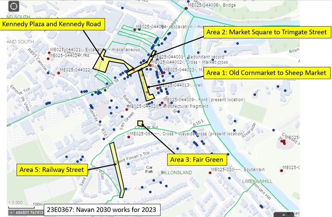
As part of ongoing works in 2023 for the Navan 2030 Town Centre improvements project (previously examined under 19E0519) it was proposed to complete extensive footpath and services works in the ‘Navan Laneways’ of Old Cornmarket, Bakery Lane, Preston Place, O Rafferty’s Lane, Metges Lane, Trimgate to Kennedy Plaza and other works in Fair Green. All these laneways are inside Navan Historic Town, ME025-044, and Old Cornmarket and Bakery lane (at least) cross presumed lines of the Navan Town Defences, ME025-044003. A new Licence, 23E0367, was taken out to cover these works. However, funding was reduced, so the actual 2023 works were reduced to:
Area 1: Old Cornmarket to Old Sheep Market (Church Hill). Site investigation pit, installation of bollards and some surface drainage at north and south ends. These works did not descend below levels disturbed by modern services and the presumed large moat-like, medieval, ditch apparently running down this lane was not seen.
Area 2: Market Square to Trimgate Street (southern gutter area of the existing road). Installation of c.30m of new, deep watermain which showed a thin gravel road surface road that is probably of post-medieval date overlying natural sands. The lack of cut features perhaps implies this was in the area of the medieval road or possibly an open area outside the nearby apparent ‘Town Defences’ seen outside Tierney’s/ZipYard (see 19E0519 Area 3 works of 2021). Other works were limited to footpath paving outside the AIB and BoI banks on the northern side of Market Square. This showed numerous services mixed with natural sands that were probably redeposited outside AIB and perhaps in situ outside BoI.
Area 3: Fair Green. A single site investigation pit to rear of the present retaining wall to Circular Road showed that this wall is built onto the face of an earlier, lower, masonry retaining wall that has a base around 2.5m below present ground level. This wall is visible in old photographs and was partly demolished in the 1980s.
Area 4: Kennedy Plaza and Kennedy Road. Installation of Electric Vehicle charger, footpath and other shallow, paving works. The Kennedy Plaza works (ITM 686828, 767824) were ‘inside’ the line of the proposed Navan Town Defences as generally understood. These showed a general and widespread ‘fill’ deposit that could be large-scale quarry-pit fills or ground-raising dumps in this low area. Alternatively, this may be a fill of some ‘Defences’; rampart ditches.
Shallow works at the Kennedy Road-Metges Lane junction and Kennedy Road-Trimgate Street junction area both showed natural gravelly-sands truncated by modern services with no cut features. Again, the lack of cut features and high levels of surviving natural deposits seems to indicate an open area here in the past (or that the area had been considerably reduced vertically in the past). A shallow services pit dug in Paddy O’Brien Street to Kennedy Road junction just showed modern services.
Navan’s Old Sheep market (significantly altered in the 1990s) was polycam scanned:
https://poly.cam/capture/8282BE10-FB0E-42D4-A76B-4B73160CF626

