2023:517 - KELLS: The Sawmills—Rear of 5-6 Church Hill, Meath
County: Meath
Site name: KELLS: The Sawmills—Rear of 5-6 Church Hill
Sites and Monuments Record No.: ME017-044
Licence number: 22E0709 Ext.
Author: Niall Roycroft
Author/Organisation Address: c/o Meath County Council
Site type: Town
Period/Dating: Modern (AD 1750-AD 2000)
ITM: E 674004m, N 775957m
Latitude, Longitude (decimal degrees): 53.728016, -6.878546
Archaeological testing in 2022 was followed by archaeological monitoring in 2023 at the Sawmills, Rear of 5–6 Church Hill, Kells, Co. Meath (site area approx. 467 sq. m of which 200 sq. m are standing buildings). The monitoring was completed on behalf of Meath County Council from 28 September–7 November 2023 (ESB connection to complete in 2024). Only post-medieval and modern material was found, although the site is in the centre of ancient Kells.
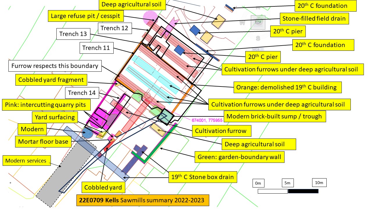
The 2023 Monitoring followed 2022 Test Excavation and was limited to 142 sq m:
• Trench 11: Reducing the interior of the main standing building by approx. 0.75m to the surface of natural ground (86 sq. m).
• Trenches 12-13: Reducing the area under the previous extension in plan by 0.5m (i.e. still within the deep garden soil: 55 sq. m) and then putting foundation trenches 18 sq. m and 7.5 sq. m within this reduced area down to the surface of natural ground.
• Excavating limited foundation trenches in the original front yard area for new foundations (14 sq. m) and services: Trenches 14–15.
In addition to this, the monitoring comprised another 40 sq. m not included in the zones above. Therefore, archaeological works covered around 185 sq. m (39%) of the site. Much of the rest of the site was basically retained in situ.
NOTE: the previous m OD levels in the testing report have been re-calibrated. The results showed natural, light yellow-brown glacial drift sloping from 79.5m OD near to Church Hill to below 77.65m OD at the northern end of the site (a distance of approx. 35m).
Monitoring results showed a series of parallel cultivation (ridge-and-) furrows oriented north-west/south-east running across the middle to northern parts of the site. These furrows were 1m wide, U-shaped in section and placed 1m apart. These reflect the Glebe Lands on 18th-century mapping and these ridges are shown on this orientation on the 1837 OS. All furrows contained 19th-century pottery and domestic waste, and some respected the existing site western boundary by terminating in front of it. The southern part of the site had a 19th-century cobbled yard built directly on natural ground and it is possible any agricultural soils had been removed from this area.
The site was developed with the original, mid-to later- 19th-century Sawmills building (under the existing building but slightly smaller). The open area on the Church Hill side was used for a mass of irregularly-shaped quarry pits. These extracted yellow sand for the 19th-century building mortar and perhaps stone for the walls. The quarry pits were then covered in a cobbled yard surface. The yard also covered a 19th-century, stone-built, communal, back drain that serviced the houses on Church Hill.
In the 1930s, the 19th-century building was demolished and rebuilt in roughly the same place using mass concrete. Ancillary buildings built on shallow, pink concrete sill beams and occasional piers, spread over part of the south-west cobbled yard and the north-east previous garden area. These building were demolished in the later 20th century.

