2023:205 - GOWEL, AGHAKILCONNELL, ANNAGHEARLY, ANNAGHKEENTY, DRUMGOWNAGH, DRUMLIFFIN GLEBE, KILNAGROSS, Leitrim
County: Leitrim
Site name: GOWEL, AGHAKILCONNELL, ANNAGHEARLY, ANNAGHKEENTY, DRUMGOWNAGH, DRUMLIFFIN GLEBE, KILNAGROSS
Sites and Monuments Record No.: LE027-093----, LE027-095----
Licence number: 22E0472
Author: Zbigniew Malek, Archaeological Management Solutions
Author/Organisation Address: Fahy’s Road, Kilrush, Co. Clare
Site type: No archaeology found
Period/Dating: N/A
ITM: E 599190m, N 803677m
Latitude, Longitude (decimal degrees): 53.982359, -8.012349
The Gowel to Kilnagross Section A–B and Section B–C scheme in County Leitrim forms part of a larger nationwide Water Network Programme that is being undertaken by Uisce Éireann. The scheme involved the installation of c.3,868m of new water mains along existing road (including associated assets, fittings and transfer of service connections). The groundworks for the Gowel to Kilnagross scheme consisted of open-cut trenching and several exploratory trenches (access pits) to facilitate the directional drilling method along the unnamed local road (L3409).
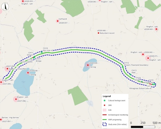
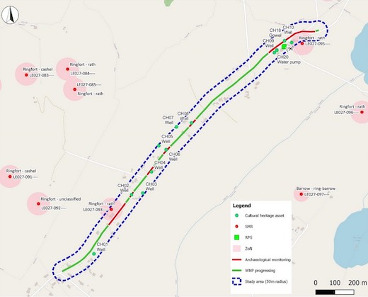
The intermittent monitoring was carried out between 9 August–12 December 2022 and between 16 January–17 May 2023 within the Zone of Notification (ZoN) for two Recorded Monuments: the ringfort-raths (LE027-093—- and LE027-095—-) intersected by the scheme in Gowel townland and – as a precaution – in the vicinity of twelve Cultural Heritage sites: along the settlement at Gowel, five wells (Section A–B), three streams, a limekiln, as well as at the location of the settlement at Kilnagross, including the location of Kilnagross School (Section B–C) due to potential for archaeological remains to be present at these locations.
Monitoring was undertaken of a section of a continuous open-cut trench totalling c.250m, excavated within the ZoN for one ringfort-rath (LE027-095) and 20m of each side, and at Gowel settlement, as well as in the vicinity of R.C.C. of St Patrick (RPS 194) and a well. The trench measured between 0.7–1m in width and between 1.2–1.4 in depth. In the eastern section of the trench, underlying the modern road surface, at a depth of 0.25–0.4m below ground level (BGL) a layer of modern redeposited material consisting of mid-greyish brown silty clay was revealed overlying the natural subsoil which consisted of mid-greyish yellow clay. This sealed a mid-grey clay with rock and boulder inclusions to a depth of 1.2–1.4m. In the western section, continuing through the Gowel settlement, underlying the modern road surface, at a depth of 0.3m BGL, bedrock or the natural subsoil which consisted of mid-grey or mid brown stoney-clay with rock and boulder inclusions to a depth of 1.2–1.4m were revealed.
Six exploratory trenches (access pits) within the ZoN for the second ringfort-rath (LE027-093) and 20m of each side were archaeologically monitored. The access pits measured between 1.6–2.6m by 0.5–1.2m by 0.7–1.5m in depth. Underlying the modern road surface, at a depth of 0.3–0.4m BGL the natural subsoil was revealed, which consisted of mid-grey stoney-clay with rock and boulder inclusions or mid-greyish yellow clay to a depth of 1.2–1.5m.
No potential archaeological objects, features or deposits were noted during the archaeological monitoring along Section A–B and Section B–C of the scheme within the ZoN for two ringfort-raths (LE027-093—- and LE027-095—-) nor within the vicinity to any of the Cultural Heritage sites.