2023:417 - BALLYCONRA (5), Kilkenny
County: Kilkenny
Site name: BALLYCONRA (5)
Sites and Monuments Record No.: N/A
Licence number: 23E0097
Author: John Channing, c/o Archaeological Management Solutions
Author/Organisation Address: 12 Parliament Street, Kilkenny, R95 Y2HE.
Site type: House - vernacular house and Gate lodge
Period/Dating: Modern (AD 1750-AD 2000)
ITM: E 643801m, N 672409m
Latitude, Longitude (decimal degrees): 52.800895, -7.350453
Stage (iii) Excavations were undertaken at Ballyconra 5 as part of the N77 Ballyragget Village to Ballynaslee Road Improvement Scheme, Co. Kilkenny.
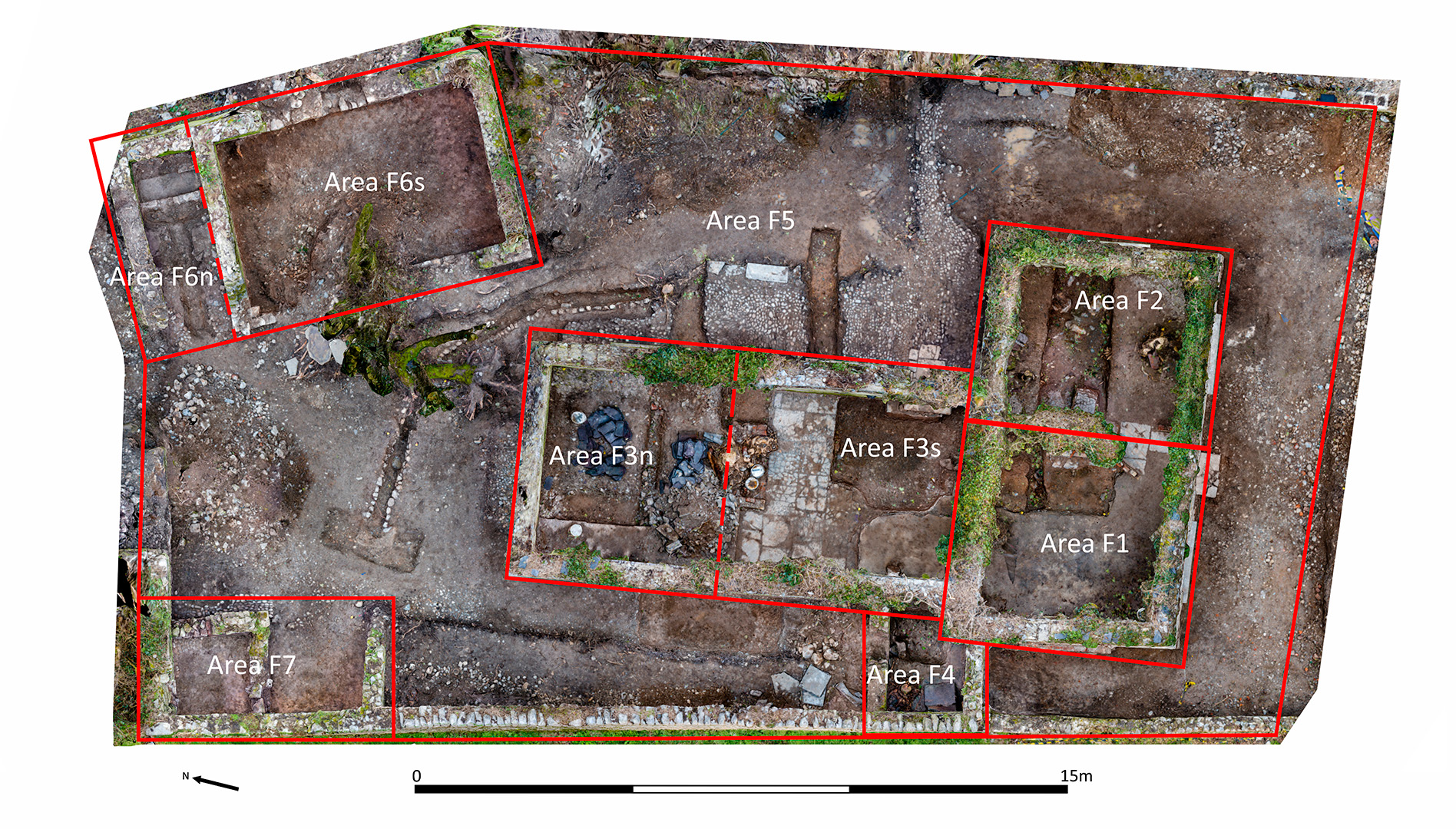
Ballyconra 5 consisted of a set of vernacular buildings that spanned the pre- and post-Famine period. The structures could be assigned to five main phases of development and approximated to structures depicted on the first-edition six inch (1842) and later 25-inch OS maps (1901).
Material reuse was evident and some of the building materials probably came from the adjacent Ballyconra Mill which burned down c.1885. The mill itself reputedly contained stone from an ecclesiastical site at ‘Anker’s Island’ some 1.3km to the north (KK004-008001).
Phases of activity were identified on the basis of historical map regression, masonry styles, wall joints and stratigraphy and consisted of:
- Phase 1: Southern portion of the outbuilding located to the northeast of main structure and boundary wall running along the west side of the site, both recorded on first-edition six-inch map. The lower level of paving C.14 and part of wall C.49 within the northern extension to the original gate lodge probably relate to rectangular structure similarly recorded.
- Phase 2: Possible gate lodge, two rooms, fronting south onto a laneway,
- Phase 3: Northern extension to the original gate lodge creating an additional room at the centre of the main structure.
- Phase 4: Northern extension to Phase 3, creating an additional room at the northern end of the main structure. Northern extension to the outbuilding to the northeast creating a narrow room. External cobbling C.22 and box drain C.33.
- Phase 5: Outbuildings at the northwest of the site. Remodelling of existing structures with inset of larger window openings with new lintels and sills. Blocking off annex F4 and alcoves C.11 and C.54.
The excavation formed part of the overall recording of the site which included an Architectural/Built Heritage Survey Report (O’Flynn 2023) and digital modelling.
Reference
Channing, J. 2023. N77 Ballyragget Village to Ballynaslee Road Improvement Scheme: Stage (i)a and Stage (i)f Report. Unpublished report by Archaeological Management Solutions on behalf of Kilkenny County Council.
O’Flynn, C. 2023. N77 Ballyragget to Ballynaslee Road Improvement Scheme Stage (i)e Architectural/Built Heritage Survey Report. Unpublished report by Archaeological Management Solutions on behalf of Kilkenny County Council.