2023:371 - BONNETSTOWN, Kilkenny
County: Kilkenny
Site name: BONNETSTOWN
Sites and Monuments Record No.: KK019-003001
Licence number: 19E0305 Ext.
Author: Niall Gregory
Author/Organisation Address: Dunburbeg, Clonmel Road, Cashel, Co. Tipperary
Site type: Excavation - miscellaneous
Period/Dating: Late Medieval (AD 1100-AD 1599)
ITM: E 646819m, N 657651m
Latitude, Longitude (decimal degrees): 52.668008, -7.307805
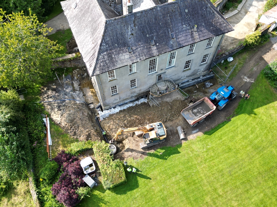
The final phase of archaeological monitoring, which had commenced in 2020, took place in 2023. This tranche of works entailed completing drainage around the mid 18th-century Bonnetstown Hall. Drainage works around the north-west and south-east sides of the house were created to further divert water from gaining access to the basement. Initially this involved opening up the ground abutting the house, which involved topsoil stripping and to make good an existing stone-capped and -lined box trench that was contemporary with the house. The culverted drain consisted of limestone capstones of 0.6m by 0.4m by 0.15m in average dimensions that were resting on mortar-bonded stone lining by the basement wall of the house on the opposing face. The more extensive drainage works subsequently required more substantial trench ducts to carry away the water. This entailed the mechanical excavation of two drainage trenches. The first ran along the north-west side of the house and 5m from the house for an overall distance of 95m to the southwest to meet and connect with a field drain at ITM 646744 657613. This trench was up to 3m in depth and 1m in width at its north-east end and lessened in depth as it travelled to southwest to a depth of 1.4m. The second substantial trench ran from either side of the steps to the front entrance from ITM 646814 657648 to 646816 657644 and from 646824 657654 to 646827 657651. At its south-eastern end, it connected to the single 1m and c. 2.2m deep trench that ran from ITM 646814 657648 to ITM 646850 657651, a distance of 40m, where similar to the first trench, it connected with an open field drain.
During the groundworks, a dressed limestone window mullion of probable medieval or post-medieval date was uncovered. This was revealed beneath the late 18th-century culverted drain that abutted the south-east side of Bonnetstown Hall on the east side of the steps at ITM 646824 657654. The cut and dressed limestone mullion is sub-rectangular, with a chamfered and bevelled face and deigned to be set as a window reveal. It measured 0.39m by 0.26m by 0.23m and retains horizontal bands of chisel marks. A rectangular recess on its face measures 3.5m by 2.5m and is 20mm in depth. The stone has the residual traces of limewash on what would have been its exposed faces.
It is possible that the mullion could have been obtained from the site of the adjacent building (KK019-003002). This building has no description available. However, local knowledge states that a church once stood here. Certainly the mullion would be in keeping with such a building, of medieval or late medieval date. One could therefore, hypothesise that this stone came from a possible church of medieval to post-medieval date that was located at the north-west end of the rear garden of Bonnetstown Hall. Furthermore, its find location beneath the late 18th-century culverted drain that surrounds Bonnetstown Hall infers that the ‘church’ may have been demolished and robbed of stone for the construction of Bonnetstown Hall, which was completed in 1753.