2023:081 - CLOGHANE, Kerry
County: Kerry
Site name: CLOGHANE
Sites and Monuments Record No.: KE035-031
Licence number: 23E0109
Author: Jacinta Kiely, Eachtra Archaeological Projects
Author/Organisation Address: Lickybeg, Clashmore, Co Waterford
Site type: No archaeology found
Period/Dating: N/A
ITM: E 450676m, N 611223m
Latitude, Longitude (decimal degrees): 52.232476, -10.186127
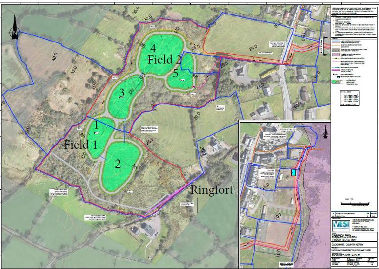
Comharchumann Forbartha an Leith Triúigh Teo has made an application to Kerry County Council for an Integrated Constructed Wetland (ICW) in An Clochán/Cloghane, Co Kerry. It comprises a 5cell ICW treatment system and associated pump station and infrastructure where wastewater will be pumped from the existing collection network to the ICW for treatment. Flow to and from the system will be operated by gravity and final discharge will be to the existing outfall in Brandon Bay. KCC issued a request for further information. The applicant has engaged Eachtra Archaeological Projects Ltd to undertake an archaeological assessment report with testing. The site is located in the townland of An Clochán and to the immediate south of the village An Clochán. A ringfort (KE035-031) is located on the eastern boundary of the site.
The area is owned by two different landowners. The southern portion (proposed location of cells 1 & 2) is accessible via a boreen that joins the R550 on the northern side of St Brendan’s RC church. Lisgortnarah ringfort is located on the south-east side of this boreen. The northern portion (proposed location of cells 3, 4 & 5) is accessible via a farm gate and green field on the western side of the R550. Ground level in the area slopes from west to east. The area is waterlogged and in general is drained by myriad of streams, many of them tributaries of An Abha Mhór/the Owenmore River, which drains into Brandon Bay.
Both sections of the site have been drained in the past and a number of land drains traverse the site and extend along the field boundaries. Large boulders have been removed from the interior of Field 1 (southernmost section) and placed along the field boundaries. Field 1 supports some growth of rough grass with a high proportion of mature rushes, mosses and gorse. The vegetation in Field 2 is different. The ground is boggy and saturated with rising water and although the area was cleared and drained in the past it has been recolonised by a dense growth of willow and rushes and gorse. This dense growth has made the southern section of Field 2 (proposed location of cell 3) inaccessible for a machine to traverse and work in.
A total of 15 trenches were excavated by machine on the footprint of the proposed ICW site. The trenches were excavated by track machine using a flat bucket. No archaeological stratigraphy, features or artefacts were recorded in any of the fifteen test trenches that were excavated in the area of proposed cells 1, 2, 4 & 5 that comprise the proposed ICW. It was not possible to excavate any test trenches in the area of proposed cell 3 due to the impenetrable growth of willow, gorse and rushes.