2023:239 - ARDRAHAN: Ferndale, Ardrahan North, Galway
County: Galway
Site name: ARDRAHAN: Ferndale, Ardrahan North
Sites and Monuments Record No.: GA114-001
Licence number: 23E0801
Author: Michael Greiner & Seán Shanahan; Shanarc Archaeology Ltd.
Author/Organisation Address: Unit 39A, Hebron Business Park, Hebron Road, Kilkenny
Site type: Historic town
Period/Dating: Modern (AD 1750-AD 2000)
ITM: E 546086m, N 712176m
Latitude, Longitude (decimal degrees): 53.157350, -8.806128
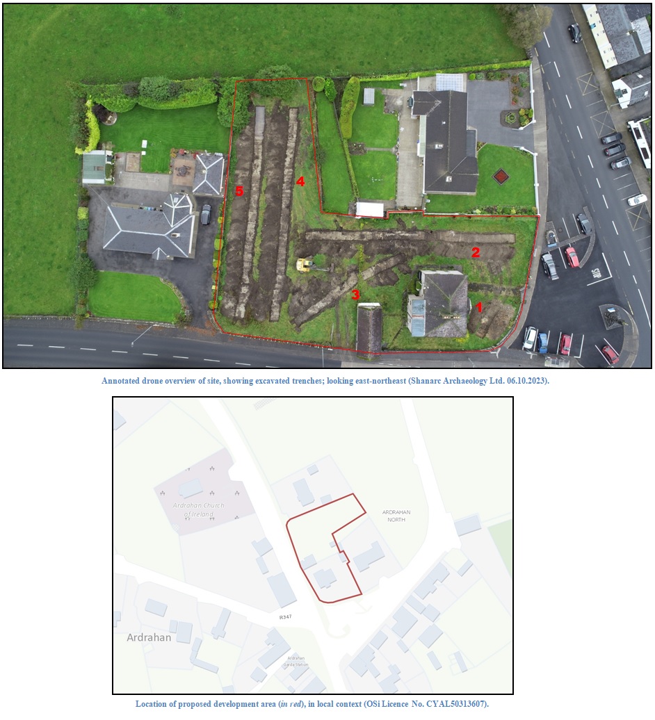
Archaeological test-excavations were carried out on 6 October 2023, as part of an Archaeological Impact Assessment, by Shanarc Archaeology Ltd. at Ferndale, Ardrahan North, Ardrahan, Co. Galway. The test-excavations related to the proposed development of a guesthouse on a c. 0.24-hectare plot located at the north of Ardrahan village within the archaeological Zone of Notification (Zone ID: R185030) for the historic town of Ardrahan (GA114-001). The site contains an historic two-storey schoolhouse with an associated detached outbuilding; the former schoolhouse is a protected structure (RPS: 883 / NIAH: 30340004).
Condition 2 of a further information request by Galway County Council regarding the associated planning application stipulated the necessity for an Archaeological Impact Assessment Report, including archaeological test-excavations.
The northern plot of the proposed development site was previously subjected to limited archaeological test-trenching carried out by Arch. Consultancy Ltd. in 2001 under Excavation Licence No. 01E0374 relating to an earlier planning application of this portion of the site. Nothing of archaeological significance was identified during testing.
The current phase of testing comprised the excavation of five test-trenches measuring 9.5-48m in length, 2m in width and 0.3-1.8m in depth. The general stratigraphy was relatively consistent through most of the trenches, comprising 0.15m of sod over c. 0.4m of moderately compact, dark brown silty sandy topsoil with a moderate amount of small and medium-sized sub-rounded stones. The underlying natural subsoil comprised a moderately compact, light grey coarse sandy gravel with a small quantity of clay mixed through it and occasional large rounded stones.
A number of modern refuse pits were uncovered in the test trenches. Foundation remains associated with an outbuilding shown at the east of the site in the historic OSi 25-inch and Cassini OSi maps were identified in Trench 2. This outbuilding is visible in all OSi aerial images from 1995–2018, though was no longer present in 2023, indicating it was removed sometime between 2018–2023. Aside from the foundation remains associated with the former outbuilding no finds or features of archaeological significance were identified during testing.