2023:787 - Kiltiernan Domain, Dublin
County: Dublin
Site name: Kiltiernan Domain
Sites and Monuments Record No.: N/A
Licence number: 22E0166
Author: Steven McGlade
Author/Organisation Address: Archaeology Plan, 32 Fitzwilliam Place, Dublin 2
Site type: Prehistoric burnt mound, wells and kiln
Period/Dating: Prehistoric (12700 BC-AD 400)
ITM: E 720235m, N 722465m
Latitude, Longitude (decimal degrees): 53.238937, -6.198750
A programme of monitoring and excavation was undertaken at Kiltiernan Domain, Co. Dublin for the next phase of an ongoing housing development. Three burnt mound sites were identified on the site in Phase 1, excavated under the same licence (Excavations Ref. 2022:175).
Phase 2 was monitored in early 2023 with no additional archaeology identified.
The works for Phase 3 were in the south and east of the development site, with the monitoring beginning in November and excavations continuing into 2024. The monitoring programme identified 68 archaeological features, with a concentration to the east relating to a fourth burnt mound site.
Excavations continued in 2024 and will be reported on separately.
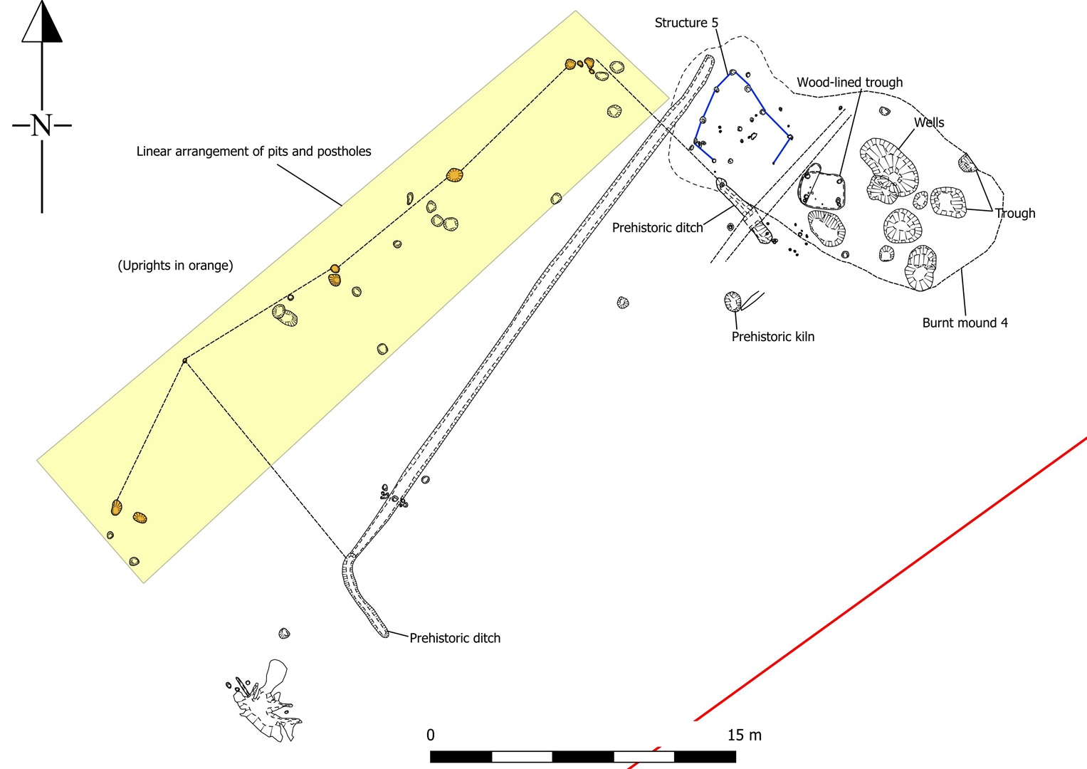
Burnt mound 4
Burnt Mound 4 included a rectangular trough, which was previously wood-lined. Post-holes were identified in each corner, with double post-holes uncovered in two of the corners. A second trough was identified that may have had a clay lining, though this was poorly surviving. A third unlined sub-rectangular trough was also identified. A shallow pit adjacent to the wood-lined trough may have been another unlined trough, or might have served another function at the burnt mound site. A largely ploughed-out burnt spread was identified. A field boundary truncated the north-east side of the burnt mound site, which may have removed much of the spread.
Unlike the previously excavated burnt mounds at Kiltiernan, which were situated at the edge of a former wetland pool or pond, Burnt Mound 4 was set back and upslope from this water source. As such, it required a different water supply. A minimum of four wells were identified, some of which were substantially recut during their lifetime. Seven cuts were identified in total. The wells and their recuts ranged in size from 3.6m by 1.9m and 1.4m in depth, to 2m by 1.4m and 1m in depth. Some of the recuts were shallower. Two of the wells had one gently sloping side, presumably to provide an access point. Prehistoric wells are frequently identified associated with burnt mound sites, with examples from South Dublin excavated at Laughanstown, Carrickmines Little and Corke Little.
A limited assemblage including prehistoric ceramics, lithics and coarse stone tools was retrieved from the fills of the wood-lined trough, the wells and the burnt spread. This is another example of a South Dublin burnt mound site associated with ceramics, with other examples known from Carrickmines Little, Carrickmines Great, Glenamuck North, Laughanstown (two sites), Shankill and Taylorsgrange, as well as Phase 1 of this site.
To the west of the burnt mound a structure (Structure 5) was identified. It was defined by shallow, poorly-surviving post-holes and appeared to have a sub-rectangular ground plan, measuring c. 4.6m by 3.2m internally. The c. 2.9m wide entrance was to the south, with a whole corner of the structure appearing to have been open. Three pairs of uprights were identified in the interior suggesting the structure had a lightweight roof. The structure resembles Hawkes’ Type C structures (2018, 102), interpreted as lightly tented structures. The structure may represent a shelter for those working at the burnt mound site.
A second smaller structure (Structure 6) was identified to the southwest of the burnt mound site. It was U-shaped in plan and defined by thirteen stake- and post-holes, measuring c. 2m x 1m internally. This was closest in form to Hawkes’ Type G structures (2018, 107). There was a low volume of charcoal within the fills of the structure and its purpose was unclear, though its proximity to the burnt mound may imply it was used for storage.
Prehistoric kiln
A small, probable figure-of-eight shaped kiln was excavated to the southwest of the burnt mound. The kiln was partially stone-lined. The chambers of the kiln were only suggested by a low ridge of natural separating the base into two parts. A complete upright saddle quern was retrieved from the north-west chamber after its latest firing event along with the upper grinding stone. Another large unworked granite stone was deposited in the south-east chamber at the same time. The stones may have been deposited in an attempt to reline the base of the kiln for later events. They may represent termination deposits, or they may have been deposited in the kiln for storage and reuse at a later date. Rare prehistoric ceramics were retrieved from the upper fills of the kiln.
Linear arrangement of pits and post-holes
A number of pits and post-holes were identified along a north-east/south-west trend southwest of Burnt Mound 4. The trend was over 30m in length and 7m in width. The features were in five groups or clusters. The clusters contained a minimum of one upright, but generally more. The uprights were positioned along the north-west side of the trend. The uprights or upright groupings were all 6.8-8.3m apart, 7.5m on average. This regular spacing appeared intentional and implies the uprights marked out space in some way, with certain activities taking place in the vicinity of the uprights.
One group was marked by a single upright, while the remaining groups had a number of pits, hearths and additional post-holes. Few artefacts were retrieved from the features, though some prehistoric ceramics and lithic artefacts were retrieved, while one of the pits to the south appeared to be a cremation pit.
One of the post-pits and three of the pits had identical fills of tightly packed unworked stone, some of which were lightly scorched, but not fractured or broken down. The deposition of the stone within these features appeared to be intentional, formal deposition.
Prehistoric ditches
Two parallel prehistoric ditches were identified to the southwest of Burnt Mound 4. The two north-west/south-east running sections of ditch were aligned on uprights within the trend described above, and were perpendicular to the alignment, further implying they relate to land division. One of the ditches appeared to define the extent of the burnt mound site, while a terminus at one end may relate to an access point. The other ditch turned at a c. 110-degree angle (influenced by a row of earth-fast boulders) to the northeast to run downhill, petering out to the east of Structure 5. A cluster of aligned stake-holes crossing this section of the ditch may represent a sluice gate that controlled water supply to Structure 5.
Reference:
Hawkes, A. 2018 The archaeology of prehistoric burnt mounds in Ireland. Archaeopress Publishing Ltd., Oxford.