2023:746 - LUCAN: Tandy’s Lane, Dobbsborough and Finnstown, Adamstown, Dublin
County: Dublin
Site name: LUCAN: Tandy’s Lane, Dobbsborough and Finnstown, Adamstown
Sites and Monuments Record No.: N/A
Licence number: 22E0884
Author: Muireann Ní Cheallacháin, c/o IAC Ltd.
Author/Organisation Address: Unit G1 Network Enterprise Park, Kilcoole, Co. Wicklow
Site type: Well
Period/Dating: Post Medieval (AD 1600-AD 1750)
ITM: E 702294m, N 733811m
Latitude, Longitude (decimal degrees): 53.344624, -6.463758
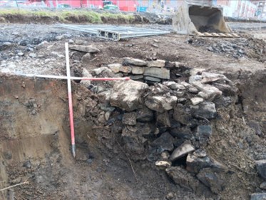
Archaeological monitoring was carried out from March to April 2023 at Tandy’s Lane, Dobbsborough and Finnstown, Adamstown, Lucan, Co. Dublin. The site stratigraphy comprised a layer of mid-brown clayey silt topsoil measuring c. 0.4–0.5m in depth, overlying a light brown silty clay subsoil with frequent angular stones. Monitoring identified a drystone-built well in the north-east sector of the site. The well was built with irregularly-shaped limestone blocks measuring roughly 0.3m long, 0.15-0.2m wide and 0.15-0.2m depth. It measured c. 1.5m in external diameter and only survived to a depth of 2m, suggesting that it has been subject to historic truncation. The well had not been backfilled and still contained water upon discovery. The wall foundation course was set directly onto the natural subsoil. The well is not depicted on any Ordnance Survey mapping, nor was it visible in the aerial photographic coverage.
During excavation of the well, bricks, shards of glass and metal objects were discovered within the stonework, which indicate that the well was likely constructed in the post-medieval period, post-1700. No other features or deposits of archaeological potential were present within the development site.

