2023:602 - DUNBOYNE/BELGREE, CO. MEATH & KINGSTOWN/CLOGHRAN/WARD UPPER/MIDDLETOWN/WARD LOWER, CO. DUBLIN, Dublin
County: Dublin
Site name: DUNBOYNE/BELGREE, CO. MEATH & KINGSTOWN/CLOGHRAN/WARD UPPER/MIDDLETOWN/WARD LOWER, CO. DUBLIN
Sites and Monuments Record No.: N/A
Licence number: Unlicensed Monitoring
Author: Thaddeus Breen; Shanarc Archaeology Ltd.
Author/Organisation Address: Unit 39a, Hebron Business Park, Hebron Road, Kilkenny
Site type: No archaeology found
Period/Dating: N/A
ITM: E 717719m, N 744096m
Latitude, Longitude (decimal degrees): 53.433804, -6.228387
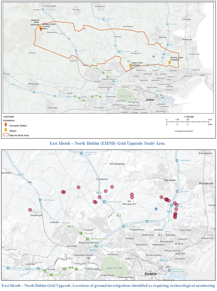
Unlicensed archaeological monitoring of exploratory ground Investigation (GI) works by Causeway Geotech Limited in association with EirGrid’s East Meath—North Dublin Upgrade project was carried out from 20 July to 25 Sept 2023. Eleven locations were monitored between Dunboyne, Co Meath and Belcamp, Co. Dublin. The GI works consisted of inspection pits, boreholes and window samples.
There were no finds of archaeological interest from these, but an early 19th-century clay pipe bowl was found 2m from one of the inspection pits.
Locations identified as being within or close to sites of cultural heritage were noted in the preliminary assessment of the archaeological potential along the route. Twenty-three locations were specified as requiring archaeological monitoring. In the first phase, ground investigations took place at eleven of these locations.
The EMND Grid Upgrade is designed to reinforce the network between East Meath and North Dublin. Reinforcement of this part of the network is needed to continue to ensure the security of the network feeding the east of Meath and the north of Dublin, between Woodland, Clonee, Corduff, Finglas and Belcamp substations. The development will add a high-capacity 400 kV underground cable electricity connection from Woodland substation near Batterstown in County Meath to Belcamp substation near Clonshagh in north Dublin.
The EMND Grid Upgrade route is approximately 37km in length. From Woodland, the route travels south for around 3km until it joins the R156 at the Barstown Industrial Estate. From there, the route travels east as far as Dunboyne, turning north along the R157 then crossing the River Tolka at M3 Parkway and M3 Motorway at Junction 5. The route then briefly progresses north along the R147 before travelling east once more along the L5026 and local roads.
The route advances east to Kilbride, with three crossings of the Ward River along the way. At Kilbride, the route turns south. The route joins the R121 a short distance to the west of the M2. Following the crossing, the route continues broadly east to the Ward Cross and stays east on the R121 until this road reaches the R122.
The route then progresses south via Kilreesk Lane (also known as Tobermurr Link Road) and Kilreesk Road (also known as Tobermurr Road) to the R108 and Naul Road along the northern boundary of Dublin Airport as far as Cloghran Roundabout, northeast of Dublin Airport.
From there, the route will briefly use Stockhole Lane travelling east to the M1 motorway. Once across the motorway, the route progresses south to Belcamp substation.

