2023:515 - DRAPERSTOWN: Lands to the rear of 41–64 St Patrick's Street, Derry
County: Derry
Site name: DRAPERSTOWN: Lands to the rear of 41–64 St Patrick's Street
Sites and Monuments Record No.: N/A
Licence number: AE/23/102
Author: Thomas McCrudden, Farrimond Macmanus Ltd.
Author/Organisation Address: Adelaide House, Belfast
Site type: Pit and Charcoal-making site
Period/Dating: Bronze Age (2200 BC-801 BC)
ITM: E 677851m, N 894506m
Latitude, Longitude (decimal degrees): 54.792461, -6.789455
Pre-development archaeological test trenching was undertaken during 18–26 September 2023, having been commissioned in response to planning conditions imposed upon grant of planning and in accordance with an approved Archaeological Programme of Works associated with Condition 12 of the planning approval.
The proposed development is located within the western outskirts of Draperstown village in an area of greenfield to the northwest of St Patrick’s Street. The site is located at Irish Grid Ref: H 77916 94515 (I.G.277916, 394515), within Tonaght townland.
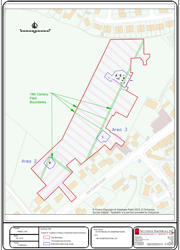
A total of twenty-seven test trenches were excavated throughout the Planning Application site. The topsoil across the development area consisted of a sandy loam which was approximately 0.3–0.4m in depth and sat above an orange/brown silty sand subsoil. Across each of the test trenches a series of faint parallel markings containing glazed ceramics were noted within the brighter orange subsoil. Many of these markings ran parallel and perpendicular to the existing field boundaries confirming them as being recent agricultural plough furrows or potato beds. Several robbed-out field boundaries were also noted crossing many of the trenches with their locations and orientations matching boundaries depicted on the 19th-century OS maps in which the area had been sub-divided into 5 smaller plots of land.
A number of features of potential archaeological nature were identified within four (TT6 & 7, TT14 & TT23) of the twenty-seven test trenches excavated. These trenches were subsequently widened at each location until a buffer zone around the archaeological features was created. Materials of an archaeological nature were confirmed as being located across Test Trenches 6 & 7 (Area 1) and Test Trench 23 (Area 2).
A number of potential archaeological features were also noted within Test Trench 14 (Area 3) surviving as three bowl-shaped pits. However, after trench widening and further hand excavation it was concluded that they were of a non-archaeological nature and likely agricultural in origin.
Area 1: This area of archaeological activity was located within the north-east portion of the proposed development and was initially identified as a spread of charcoal-rich material within Test Trench 6. Topsoil stripping around this spread revealed it to be a 2m by 1m rectangular charcoal spread with an agricultural linear cutting across the top. The spread material consisted of a dense but thin mat of charcoal pieces which produced a single sherd of prehistoric pottery. Several other charcoal-filled features were also uncovered surrounding the pit, including possible spreads, stake and post-holes, some of which produced more prehistoric pottery. A smaller (c. 0.5m by 1m) isolated irregular charcoal-stained pit was uncovered to the southwest. This area was also widened, however no other features were uncovered.
Area 2: This area of archaeological activity was located within the south-west portion of the development area, centred on Test Trench 23, and contained two closely set charcoal-rich spreads. One appeared to have a shallow bowl-shaped cut with reddening of the subsoil suggesting an in-situ hearth. It was approximately 1m wide and 2m long and teardrop shaped in plan. The second spread was approximately 1m in diameter and may represent material removed from the adjacent feature. After widening around these features no other archaeological material was recovered.
Area 3 was deemed to have contained non-archaeological materials and therefore no further action was taken.
Discussion
Two areas of archaeological activity were uncovered during archaeological test trenching at the site of proposed development at St Patrick’s Street, Draperstown. Area 1 comprises of a number of charcoal-stained spreads which may represent the remains of pits and post-holes. The largest feature measured 1m by 2m and may represent the remnants of an industrial charcoal-producing pit. Prehistoric pottery recovered from the surface of a number of these features confirms their archaeological nature. Area 2 contained two closely-set spreads with the larger of the two potentially representing the remains of a hearth.
The Evaluation report (“Results of Archaeological Test Trenching and Excavation Strategy relating to proposed development at lands to the rear of 41 – 64 St Patrick’s Street, Draperstown, Co Londonderry.” FarrimondMacManus Ltd dated 4th October 2023) outlines the results of the test trenching and sets out
recommendations for mitigating the impact of proposed development works on archaeological features, remains and deposits identified during evaluation works through licenced archaeological excavation and recording as a means of providing for their preservation through record.
It is currently anticipated that archaeological excavation and recording works will be undertaken within Areas 1 & 2 during early 2024.