2023:613 - GNEEVES, Boherboy, Cork
County: Cork
Site name: GNEEVES, Boherboy
Sites and Monuments Record No.: N/A
Licence number: 23E0743
Author: Tim Counghlan, c/o IAC Ltd.
Author/Organisation Address: Unit G1 Network Enterprise Park, Kilcoole, Co. Wicklow
Site type: Charcoal-making site and Kiln
Period/Dating: Multi-period
ITM: E 526340m, N 601535m
Latitude, Longitude (decimal degrees): 52.160727, -9.076610
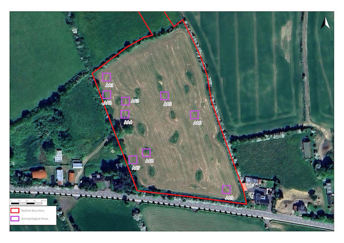
A programme of test trenching took place on 12 and 13 September 2023 at proposed development site located in the townland of Gneeves, Civil Parish of Kilmeen and Barony of Duhallow, in County Cork. A total of 27 trenches were excavated across the site measuring 730 linear metres. The trenches targeted geophysical anomalies and open green space to fully investigate the archaeological potential of the site.
Testing revealed nine areas of archaeological significance, which have been designated as Archaeological Areas 1–9. All of these areas related to similar types of activity associated with charcoal production. While some of the areas had typical scorched red subsoil sealed by a rich layer of black charcoal overlain by a light brown loamy clay, some were characterised by just the evidence of in-situ burning—possibly having been previously disturbed by ploughing.
AA1
The archaeological feature was a sub-rectangular charcoal-production pit: 2.3m long, 1.1m wide and 0.2m deep.
AA2
The archaeological feature was a sub-rectangular charcoal-production pit: 2.15m long, 0.95m wide and 0.18m deep.
AA3
This was an area of in situ burning measuring c. 1m x 1m. It may represent a heavily ploughed-out charcoal-production pit with only the scorched subsoil surviving and extending beyond the south of the trench.
AA4
This was an area of in-situ burning measuring c. 1.4m x 1.4m. It may represent a heavily ploughed-out charcoal-production pit with only the scorched subsoil surviving and extending beyond the west of the trench.
AA5
Two adjacent charcoal-production pits were identified at AA5. Both were sub-oval in plan and heavily truncated although elements of the charcoal-rich fill of both was evident as well as the underlying scorched subsoil. The first (C12.1) was 1.4m long and 1m wide. The second (C12.2), located immediately to the north, was 1.3m long and 0.8m wide. Both were truncated by a north–south furrow.
AA6
This was a charcoal-production pit 1.3m wide that extended beyond the west of the trench. It was 0.2m deep.
AA7
This was an area of in-situ burning measuring c. 1.2m x 1.2m. It may represent a heavily ploughed-out charcoal-production pit with only a thin lens of black charcoal-rich material overlying the scorched subsoil surviving and extending beyond the west of the trench.
AA8
A sub-oval charcoal-production pit that extended beyond both sides of the trench indicating that it was more than 1.8m long. It was between 1.1m and 1.8m wide and was 0.25m deep.
AA9
This was charcoal-production pit 1m x 1m x 0.15m deep, although it was heavily truncated on its east side by a linear furrow, and may also continue beyond the eastern limit of the trench.
It was recommended to excavate all identified archaeological areas (AA1-9) and that all ground disturbances associated with the development be monitored by a suitably qualified archaeologist.