2023:423 - KILLAMURREN, Bartlemy, Cork
County: Cork
Site name: KILLAMURREN, Bartlemy
Sites and Monuments Record No.: CO053-029001
Licence number: 23E0633
Author: David Murphy
Author/Organisation Address: 3a Westpoint Trade Centre, Link Road, Ballincollig, Cork
Site type: Ecclesiastical enclosure
Period/Dating: Medieval (AD 400-AD 1600)
ITM: E 581750m, N 585594m
Latitude, Longitude (decimal degrees): 52.022049, -8.265912
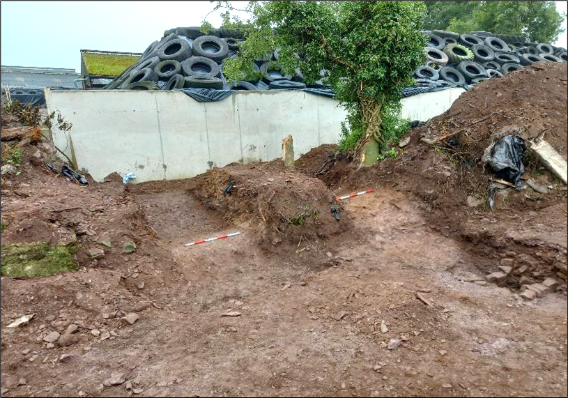
The permitted development works were located in and around an ecclesiastical enclosure (CO053-029001-) and entailed the removal of part of the last surviving portion of the enclosing bank of the site. This westernmost portion of the enclosing bank proved to be heavily disturbed by both modern activity and tree growth, consequently, archaeological excavation was only viable across a limited section of the area.
The excavation demonstrated that large amounts of modern material had been deposited against the bank of the ecclesiastical enclosure during the modern period. When the original bank itself was revealed, it proved to be extremely denuded, likely as a result of both environmental and anthropogenic factors. Beneath the modern overburden, it survived to a height of between only 0.5m and 0.6m and had a width of c. 2.55m (east-west) at its base. The bank had been completely removed by modern disturbance in the area to the north of the excavation area, while the area to the south was also heavily disturbed and contained large amounts of waste debris, some of which was unhygienic. This precluded any manual investigation in this area.
No evidence of an external fosse or any other internal or external archaeological features were revealed. A culvert, likely 19th -century in date, was revealed extending across the area external to the westernmost section of the enclosure.
This feature appears to have been constructed in conjunction with the old public roadway at some point in the early to mid-19th century. While the upper levels of the culvert were disturbed by modern activity, its lower portions still retained water.
Subsequent monitoring of site clearance and ground reductions revealed no further archaeological features. Following the removal of the subject portion of bank during the permitted development, approximately 20% of the original bank which enclosed the ecclesiastical site remains extant. This extant section is situated to the immediate south of the modern farmyard.