2023:232 - MALLOW CASTLE, Cork
County: Cork
Site name: MALLOW CASTLE
Sites and Monuments Record No.: CO033-009004
Licence number: E005519
Author: Ros Ó Maoldúin/AMS
Author/Organisation Address: Fahy's Rd, Drimna, Kilrush, Co. Clare, V15 C780
Site type: Castle - tower house
Period/Dating: Multi-period
ITM: E 556250m, N 598114m
Latitude, Longitude (decimal degrees): 52.133158, -8.639046
This report presents the preliminary findings of an archaeological excavation at Mallow Castle, Castlelands townland, Co. Cork under Ministerial Consent number C000893 and registration number E005519.
The first castle at Mallow was built in 1185 under the instructions of King John (Berry 1893a). The location of the twelfth-century castle keep is unknown; however, it is likely that it was set within the bawn, perhaps where the fortified house (CO033-009001-) now sits, or under the site of the country house (CO033-009003-). A large tower-house and surrounding bawn reportedly served as the castle for the Earls of Desmond until the late sixteenth century (Berry 1893a & b). In the late sixteenth century, Sir Thomas Norreys, a senior English administrator in charge of managing Munster, built a fortified house (CO033-009001-) at the site. Today, this is a ruin of a rectangular three-storey house with four-storey towers. The house was assaulted and ruined by the Confederate forces in 1645 and burned down in 1689 (Grove White 1905–25, vol. 4, 85). The inhabitants are reputed to have retreated to stables (CO033-009002-) (Bence-Jones 1978, 200). The country house (CO033-009002-) is a large multiperiod complex, the majority of which appears eighteenth and nineteenth century in date, but some internal walls are up to 1m thick and are thought to include sixteenth-century stables, where people hid in the seventeenth century (Bence-Jones 1978, 200).
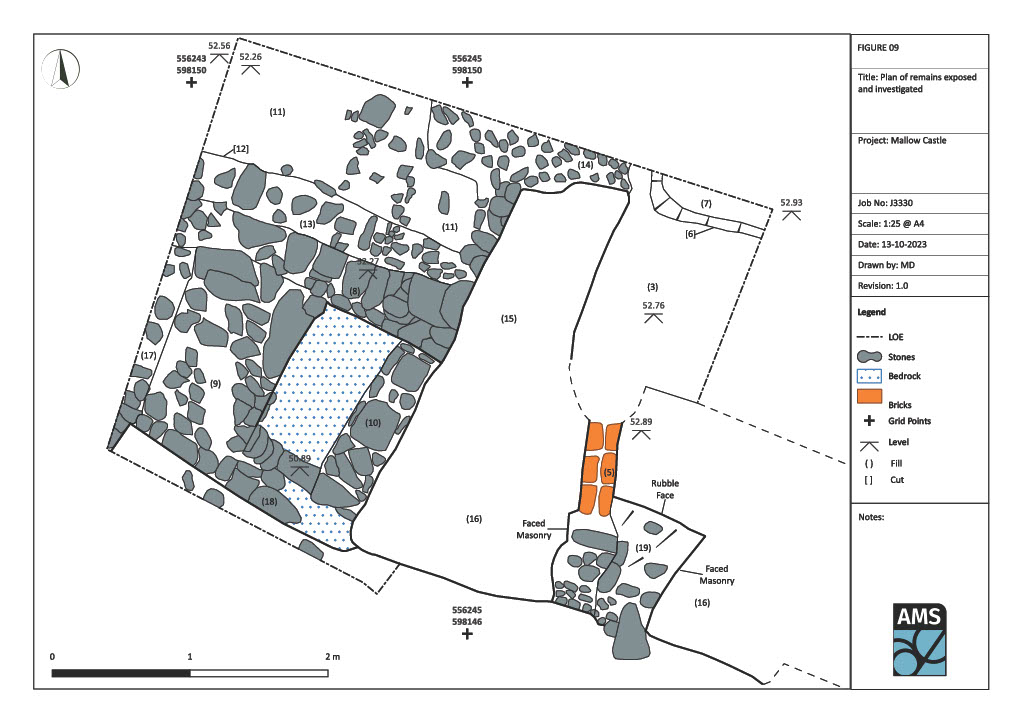
These excavation works focused on the poorly preserved mural tower on a bawn (CO033-009004-/CO033-009006-) at the southeast of the Mallow castle complex. The tower was partway through conservation works being undertaken by the Office of Public Works and the aim of the excavation was to investigate a hole leading from the tower interior into a garderobe shaft and set of possible steps to its west (see excavation attached plan). The excavation revealed that the hole that led from the interior of the tower into the garderobe is a secondary feature that punched through into the earlier garderobe. It was 0.22m wide and 0.2m deep; its base was lined by brick, its sides by stone and it was capped with slate. It likely served as a drain and may date from the late sixteenth century, the same time that the nearby fortified house was built by Sir Thomas Norreys. Typological analysis of a loose brick from this structure retrieved during the excavation may add weight to or refute this supposition, and scientific characterisation has further potential to source the clay for this seemingly early brick. No steps were revealed to the west of the tower remnant, however, a series of foundations and revetted edges were. One of these, an east–west wall (C.8), although not very substantial may be the bawn. The others that extended from its southern face may either have supported, buttresses to the bawn, steps or a slipway from the bawn down toward the river, or some other form of projecting superstructure. A semi-articulated pair of animal bones were found in a mortar deposit post-dating a short wall remnant (C.10) that abutted the main east–west wall (C.8) and the standing tower remnant (C.15). It is intended to identify and then obtain a radiocarbon date on a sample of that bone.
Four mortar samples were also retrieved, one from a layer found inside the tower and running under the standing tower wall faces, one from the core of the garderobe wall, one from mortar binding the drain, and one from the mortar in which the animal bone was found. It is intended to have all four mortar samples analysed and should suitable carbonised material exist in the first three, these may also be considered for radiocarbon dating.
No medieval artefacts were found during the excavation, however glass, pottery, brick, tile, clay pipe, animal bone and slate of post-medieval to modern date was retrieved. These will be analysed and reported on as advised by relevant specialists.
This summary will be updated upon completion of the final excavation report.
References
Bence-Jones, M. 1978. Burke’s Guide to Country Houses: Volume 1 Ireland. London: Burke’s Peerage Ltd.
Berry, H. F. 1893a. ‘The manor and castle of Mallow in the days of the Tudors’. Cork Historical Society Journal. Ser. 1, Vol. 2, No. 14, pp.21–25.
Berry, H. F. 1893b. ‘The manor and castle of Mallow in the days of the Tudors (contd.)’. Cork Historical Society Journal. Ser. 1, Vol. 2, No. 15, pp.41–45.
Grove, W.J. 1905–25. Historical and Topographical Notes etc. on Buttevant, Doneraile, Mallow, and Places in their Vicinity, 4 vols. Cork: Guy.