2022:308 - BLESSINGTON: Blessington Demesne & Deerpark Phase 1, Wicklow
County: Wicklow
Site name: BLESSINGTON: Blessington Demesne & Deerpark Phase 1
Sites and Monuments Record No.: WI005-018, WI00137, WI005-123
Licence number: 21E0133
Author: Muireann Ní Cheallacháin, c/o IAC Archaeology Ltd.
Author/Organisation Address: Unit G1 Network Enterprise Park, Kilcoole, Co. Wicklow
Site type: Excavation - miscellaneous
Period/Dating: Multi-period
ITM: E 697860m, N 714993m
Latitude, Longitude (decimal degrees): 53.176400, -6.536108
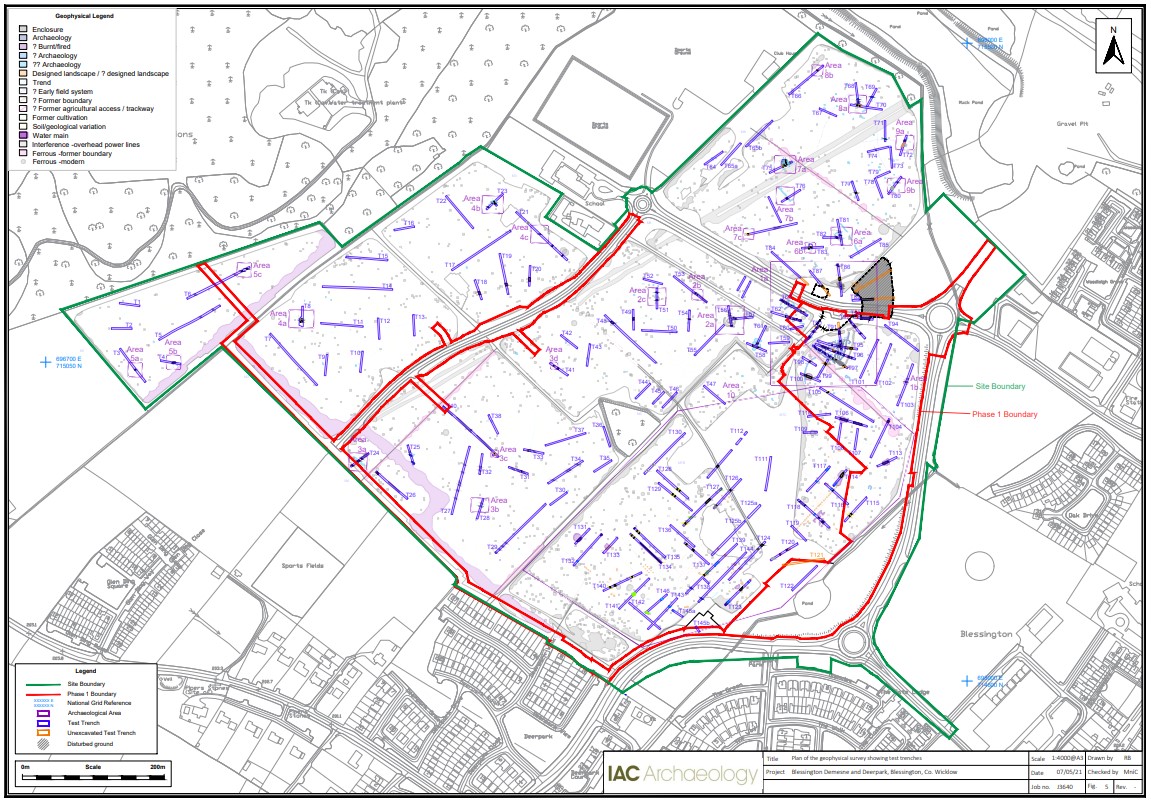
Archaeological testing was undertaken at Blessington Demesne and Deerpark, Blessington, County Wicklow, between 18 March and 8 April 2021. A total of 148 trenches were excavated across the site, measuring 6820 linear metres in total. The trenches targeted the zone of notifications for the recorded monuments WI00137, WI005-123, geophysical anomalies and open green space.
The proposed development is located immediately adjacent to the site of Downshire House (WI005-018) and extends slightly into the associated deer park (WI005-123), both of which are subject to statutory protection. Downshire House (WI005-018) was constructed in 1673 and burnt down in 1798. A designed geometric landscape was established as part of the demesne associated with the house, along with the Deerpark further to the northwest. Elements of this landscape survive today within the proposed development area, including demesne walls and a pond.
Archaeological testing identified a number of archaeological features and deposits across the site. These features have been grouped into ten Archaeological Areas (AA1–10), which are summarised below:
AA 1a–b: This area is characterised by a heavily truncated sub-rectangular ditched enclosure (possible original int. diameter: 75m x 65m) and the partial remains of an annex to the south of the enclosure, as identified in the geophysical survey. Pits, post-holes, hearths, possible circular and rectangular slot trench structures and evidence of metalworking of both iron and non-ferrous metals were identified to the west of the surviving annex enclosure ditch and are interpreted as possible habitation and/or industrial features. The geophysical survey depicts further pit and linear features located within the annex enclosure outside the current trench locations. A post-medieval field boundary ditch possibly truncates the western arm of the annex enclosure. Several pit and slot trench features were identified to the west of the rectangular enclosure that may be contemporary with it.
AA 2: Prehistoric activity in the form of a c. 15m diameter bivallate ring-ditch, a charcoal clamp and pit and a possible slot trench structure of unknown date. The shallow nature of the enclosure ditches suggests that the site has been heavily truncated by agricultural/landscaping activity.
AA 3: A hearth, kiln and pits of unknown date and linear features associated with a 17th-century lane associated with Downshire House.
AA 4: Possible prehistoric structures.
AA 5 Possible prehistoric activity in the form of a charcoal clamp, post-holes and possible trough associated with burnt mound activity.
AA6: Possible early medieval activity in the form of a 10m diameter C-shaped slot trench with pits and in-situ oxidisation.
AA7: Possible early medieval activity in the form of a cluster of features associated with industrial activity, a possible field system and a kiln.
AA8a–b: Possible prehistoric activity in the form of hearths and pits.
AA9a–b: Prehistoric activity in the form of a burnt spread and waste pits.
AA10: 17th–18th-century activity associated with Downshire House (WI005-018) and its designed landscape/gardens.