2022:027 - NEWCASTLE MIDDLE, Wicklow
County: Wicklow
Site name: NEWCASTLE MIDDLE
Sites and Monuments Record No.: WI019-005
Licence number: 21E0590
Author: Siobhán Deery
Author/Organisation Address: Lynwood House, Ballinteer Road, Dublin 16
Site type: Mill - corn
Period/Dating: Modern (AD 1750-AD 2000)
ITM: E 729349m, N 704193m
Latitude, Longitude (decimal degrees): 53.072675, -6.069673
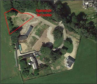
Archaeological testing was carried out in advance of the development of a single dwelling located in a former farm yard on the site of a 19th-century corn mill. The development is located within the zone of archaeological potential of Newcastle Middle Historic Town (WI019-005), as shown in the paper RMP map survey. There are no recorded monuments within the application area. A recorded masonry castle (WI019-005002) and a castle-ringwork (WI019-005004) are situated c. 100m to the north-west of the site. A church (WI019-005001) with an associated graveyard (WI019-005006) and a recorded headstone (WI019- 005007) lie c. 175m to the west. An unclassified barrow (WI019-079) is located at c. 440m to the south.
The testing confirmed the general disturbance of the site, which most recently included the construction of a shed in the 1960s.
It identified the former watercourse channel for the Newcastle river. The river was diverted north to its present location to facilitate the development of a corn mill in the late 19th/early 20th century, which was in place by the time the 1909 OS 25-inch OS map was published. The mill went out of commission in the 1950s, and its associated mill races were backfilled, and the land returned to agricultural use.
The test excavation identified the remnants of the 19th-century milling activity and modern disturbance. No in-situ soils, features or deposits of archaeological interest were found in the trench opened within the proposed development area.