2022:822 - DAVIDSTOWN, Enniscorthy, Wexford
County: Wexford
Site name: DAVIDSTOWN, Enniscorthy
Sites and Monuments Record No.: N/A
Licence number: 21E0690
Author: Seán Shanahan, Robert Hanbidge & Michael Greiner; Shanarc Archaeology Ltd.
Author/Organisation Address: Unit 39a, Hebron Business Park, Hebron Road, Kilkenny
Site type: Fulacht fia and Pit
Period/Dating: Multi-period
ITM: E 693145m, N 636471m
Latitude, Longitude (decimal degrees): 52.471717, -6.629009
Archaeological monitoring took place of groundworks in relation to a solar farm development on a c. 10.2ha agricultural greenfield site in the townland of Davidstown, Enniscorthy, Co. Wexford.
Monitoring was carried out in two phases. The initial phase took place between 15 November and 18 December 2021, and comprised the monitoring of excavations relating to the construction of the site access road as well as soil stripping in the location of the proposed substation at the south of Field A. The second phase of monitoring was conducted in June 2022, and consisted of monitoring the excavation of the service connection trenches across the site.
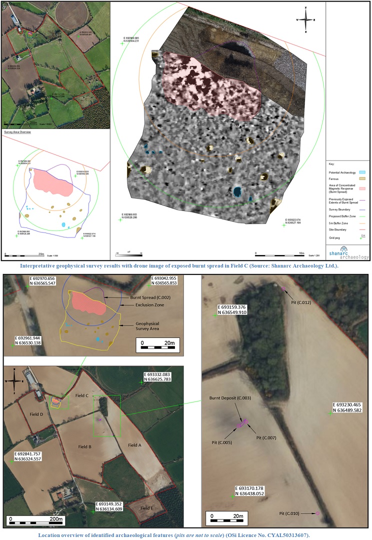
During the initial phase of monitoring, a burnt spread (C.002), likely associated with a burnt mound or fulacht fia, was identified at the northwest of the site. The burnt spread was preserved in situ, and the surrounding area was subjected to a geophysical survey (22R0089). The geophysical survey established the limits of the burnt spread and identified a number of additional anomalies possibly representing pit-type features. Following the geophysical survey, an exclusion zone was implemented around the identified features and the site development layout was updated to avoid this area of the site. The burnt spread/fulacht fia was approximately centred on ITM coordinates E 693010, N 636557.
The second phase of monitoring related to the excavation of the service cable trenches for the solar farm, in Fields A, B & C. Two adjacent pits (C.005 & C.007) and an associated burnt deposit (C.003) were identified at the northeast of Field B, and a further isolated pit (C.010) was identified c. 70m to the south-southeast. An additional pit (C.012) was identified in Field A. Pit C.005 was approximately centred on ITM coordinates E 693173.787, N 636481.798. Pit C.007 was approximately centred on ITM coordinates E 693178.621, N 636484.245. Pit C.010 was approximately centred on ITM coordinates E 693222.712, N 636427.798. Pit C.012 was centred approximately on ITM coordinates E 693201.455, N 636566.358. Radiocarbon dates obtained from charcoal recovered from four of the five identified features ranged from the Early Bronze Age to the Medieval period. The earliest feature comprised Pit C.010 dated to the Early Bronze Age (1953–1769 cal BC), the burnt spread C.002 was dated to the Late Bronze Age (1187–933 cal BC), Pit C.005 was dated to the Early Iron Age (792–550 cal BC) and Pit C.007 was dated to the early medieval/medieval (1023–1156 cal AD). No radiocarbon dates could be produced for the fifth identified feature, Pit C.012.
With the exception of a single sherd of 19th-century pottery recovered from below the topsoil in the substation area of the site, no finds were recovered during monitored works.
All the archaeological features identified during monitoring were preserved in situ within the service trenches.