2022:088 - TINCONE AND BURGESS, Wexford
County: Wexford
Site name: TINCONE AND BURGESS
Sites and Monuments Record No.: N/A
Licence number: 22E0028
Author: Yvonne Whitty
Author/Organisation Address: Unit 10, Riverside Business Centre, Tinahely, Co. Wicklow
Site type: Military camp
Period/Dating: Modern (AD 1750-AD 2000)
ITM: E 705658m, N 623045m
Latitude, Longitude (decimal degrees): 52.348807, -6.449138
An archaeological Impact Assessment Report with test trenching was undertaken for of all three phases of a proposed mixed-use development and ancillary site works including coastal protection measures in the townlands of Tincone and Burgess, Co. Wexford.
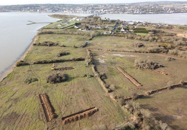
Test trenching was completed over the entire development which was for the most part subject to geophysical survey. The geophysical survey identified trends of archaeological significance including pit-like features and a sub-rectangular feature with parallel ditch along with the potential sub-surface remains of a US Naval Air Station.
There are no recorded monuments within the application area.
The most significant cultural heritage remains was the possible survival of subsurface remains of a World War I US Naval Air Station dating from 1918 within the development site. Aerial photograph analysis indicated that modern dwellings occupy the location of the main buildings on site. There are, however, buildings visible under construction on an aerial photograph taken in 1918 which extend to the the north into the development site. Construction of the Naval Station began in February 1918 but ceased in November that year when the armistice was signed.
The test trenching confirmed that there were no traces of the air base within the development site.
A total of 24 test trenches were excavated over the linear features and elsewhere throughout the site totalling approximately 1,360m. This was to confirm if the features identified in the survey were of archaeological significance and if remains of the Naval Air Station or any other archaeological features survive within the development site. Test trenching confirmed that, apart from a few concrete blocks in one of the boundary ditches at the south-west end of the site, there are no remains of the base within the development area. The linear features identified in the geophysical survey appear to be possibly agricultural and not of archaeological significance given the lack of associated archaeological features. It must be borne in mind that only a small section of these features were tested so archaeological monitoring of this area during construction to confirm this interpretation is recommended.
Archaeological monitoring for the excavation of the coastal protection works is also recommended given the scale of the development and the construction scenario which will involve the laying of ECAB revetment which will be bedded into the beach to a depth of 1m along the coastal area of the development.