2022:734 - RATHNASKILLOGE SUBSTATION, Waterford
County: Waterford
Site name: RATHNASKILLOGE SUBSTATION
Sites and Monuments Record No.: N/A
Licence number: 22E0542
Author: András Hindli
Author/Organisation Address: Burnside, St. Oran's road, Buncrana, Co. Donegal
Site type: Burnt spread and Pit
Period/Dating: Bronze Age (2200 BC-801 BC)
ITM: E 637512m, N 600716m
Latitude, Longitude (decimal degrees): 52.157004, -7.451779
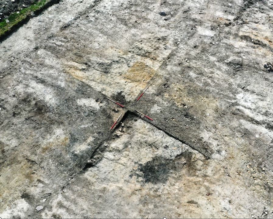
An archaeological excavation was undertaken at the site of an electrical substation associated with a Solar Farm in the townland of Rathnaskilloge, County Waterford in August 2022. Two cuttings were stripped of topsoil, targeting archaeological features identified during a previous programme of archaeological testing (licence no. 22E0305). Both cuttings revealed the presence of very disturbed and truncated burnt spreads masking a total of three pits/troughs underneath. Radiocarbon dates from both cuttings place these features within the Early Bronze Age.
CUTTING A:
Cutting A measured 20m x 20m (400m2) and contained a burnt spread and pit/trough feature located within its south-western portion.
The burnt spread consisted of a black/dark brown, moderately loose, silty clay deposit containing frequent inclusions of heat-affected stones and flecks of charcoal, and was associated with prehistoric pyrolithic technology. This feature was irregular in plan and measured 5.3m north-east/south-west by 3.5m and had an average thickness of 0.2m. Flint was found within this feature in quadrant ‘C’, likely representing debitage from flint knapping. A pit/trough feature was revealed underneath the burnt spread, after the excavation of quadrant ‘D’. The spread of burnt material was highly disturbed by modern agricultural activities and was heavily reduced. Deep ploughing scars were visible cutting through this feature, creating lenses of mixed deposits. In addition, the the south-west portion of the burnt spread had been truncated by a north-west/south-east orientated linear drainage ditch (1.1m wide and 0.8m deep) carrying a plastic pipe at its base. An ex-situ drag of burnt mound material was visible within the fills of this modern ditch feature. Ground disturbance was also evident towards the north-western end of burnt spread where a deposit of buried soil was noted.
A pit/trough feature was identified within quadrant ‘D’ (eastern portion of the spread) below the burnt spread. This feature had a sub-oval shape in plan, orientated north-east/south-west, and measured 1.72m north-east/south-west by 1.52m, and 0.55m in depth. The result of the radiocarbon dating of the basal fill was Cal BC 2135-1942 (Early Bronze Age).
CUTTING B:
Cutting B measured 25m x 25m (625m2) and contained a burnt spread and two potential troughs.
The burnt spread consisted of a black/dark brown, loose, silty clay deposit containing frequent inclusions of heat-affected stones and occasional patches with concentrations of charcoal flecks. This feature was irregular in plan and measured 4.18m east-north-east to west-south-west by 7.95m with a thickness of 0.06–0.12m. Two potential troughs were revealed underneath the middle and northern portions of the burnt spread. Evidence of considerable disturbance and truncation was noted in relation to the burnt spread which had a very mixed and levelled appearance. Modern deep plough marks and boreholes were also present. Pockets of mixed topsoil and subsoil were visible on the surface of the spread and in section. In addition, a modern field drain running east-west truncated both the burnt spread and one of the potential troughs underneath.
Upon excavation of quadrant ‘D’ of the burnt spread, a potential trough was revealed at the northern portion of the same. This trough contained a single fill and was slightly truncated to its north-western margins by modern disturbance. This feature had a sub-circular shape in plan and measured 1.4m northeast to southwest by 1.3m, with a depth of 0.35m. It was filled by a single deposit of black/dark brown, loose, clayey silt containing frequent small sized subangular stone and flecks of charcoal. This fill likely entered the cut following the disuse of the trough and was possibly dragged or silted in from the burnt spread.
A second, slightly larger, trough was revealed approximately 2.4m to the south of the aforementioned feature, specifically under the middle portion of the burnt spread, mostly exposed within quadrants ‘A’ and ‘C’. This potential trough contained a single fill and its northern margins were truncated by a modern drain orientated east-west. The trough was sub-oval in plan and measured c.1.85m in length, 1.5m in width, and 0.26m in depth. The result of the radiocarbon dating of this feature was Cal BC 2014–1775 (Early Bronze Age)

