2022:474 - RATHNASKILLOGE, Stradbally, Waterford
County: Waterford
Site name: RATHNASKILLOGE, Stradbally
Sites and Monuments Record No.: N/A
Licence number: 22E0305
Author: András Hindli
Author/Organisation Address: Burnside, St. Oran's road, Buncrana, Co. Donegal
Site type: Excavation - miscellaneous
Period/Dating: Multi-period
ITM: E 638114m, N 600615m
Latitude, Longitude (decimal degrees): 52.156055, -7.442992
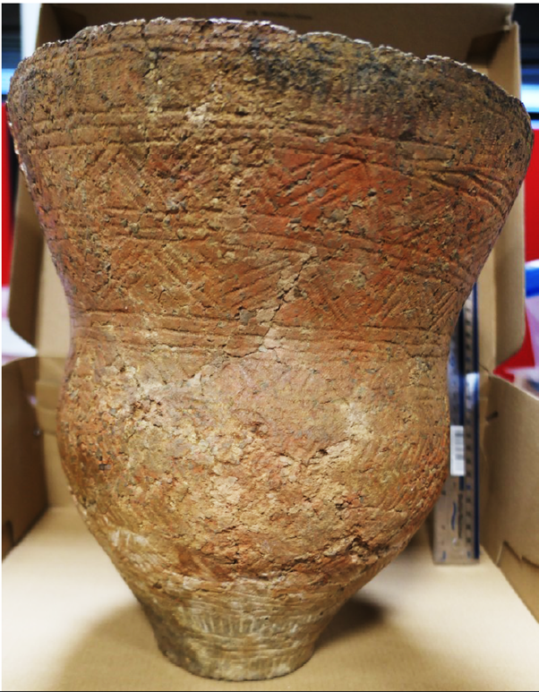
A large programme of archaeological testing carried out in Rathnaskilloge townland (Co. Waterford) confirmed the presence of several potential previously unrecorded archaeological features, ranging in date from the prehistoric to post-medieval period. While conjectural in the absence of full excavation, these include possible settlement site activity with evidence of structures, field systems, pits, hearths and a number of burnt mounds/fulachta fiadh; sites of possible ritual or burial activity with evidence of a possible cairn, including the discovery of a mostly intact beaker pottery from possible ring ditch context.
In order to spatially summarise the results of this programme, an ‘id’ number was assigned to each enclosed/individual field containing at least one archaeological feature. The following is a summary of the archaeological sites/features identified within the townland of Rathnaskilloge:
RS-01 (ITM 637984, 600346): Small burnt spread and rich in charcoal pit.
RS-02 (ITM 637975, 600467): Two large pit-like features, one being sub-circular in plan, concave cut, with a single fill/deposit containing charcoal inclusions and frequent medium-sized sub-angular stones. The second was similar in composition extending beyond the limit of the trench.
RS-03 (ITM 638152, 600401): Possible cairn, slot-trench structure and early field systems. The possible cairn consisted of a circular pattern of boulders and cobbles set on edge. The feature measured 8m in diameter with the stones extending through the topsoil and many of the larger boulders (dims 1m x 0.6m x 0.15m) were plough scarred. Cobbles within the feature averaged 0.2m x 0.3m x 0.1m. A Recorded Monument (WA024-051) corresponding to the site of a former/previously disturbed cist is located approx. 20m south of the possible cairn.
RS-04 (ITM 638238, 600532 and 638238, 600532): Burnt mound and several burnt spreads. The burnt mound consisted of heat-shattered stones and charcoal, 0.1m below existing surface level and underlying a peaty topsoil. It measured approximately 8m in length, extending beyond the limits of the trench.
RS-05 (ITM 638114, 600615): Mostly intact decorated beaker vessel, possible ring ditch, pit-like features, hearth and remnants of a lime kiln. An extension to this licence permitted the block-lifting and analysis of the prehistoric vessel.
RS-06 (ITM 638081, 600733 and 638080, 600618): A total of 8 features were identified, consisting of several small pit-like features, hearths and stake-holes located slightly less than 20m west of the aforementioned decorated beaker vessel and possible ring ditch.
RS-07 (ITM 638161, 600798): Over 40 potential features were identified within this field, including: early field systems/enclosures, slot-trench structure, hearths, pit-like features, post-holes, limekilns and a large, curvilinear early field boundary (shown on geophysical survey to extend through several current field divisions).
RS-08 (ITM 637511, 600711): Two burnt spreads. This site was excavated under a different licence and revealed 3 troughs/pits and flint artefacts underneath the spreads.

