2022:956 - N74 Ballyhusty Realignment Scheme, Corrogemore 1, Tipperary
County: Tipperary
Site name: N74 Ballyhusty Realignment Scheme, Corrogemore 1
Sites and Monuments Record No.: -
Licence number: 21E0835
Author: Kate Taylor, TVAS (Ireland) Ltd
Author/Organisation Address: Ahish, Ballinruan, Crushee, Co. Clare
Site type: Prehistoric artefacts, early medieval enclosure
Period/Dating: Multi-period
ITM: E 591720m, N 636490m
Latitude, Longitude (decimal degrees): 52.479770, -8.121892
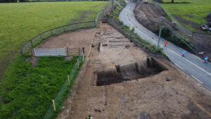
Corrogemore 1 was located on the proposed N74 Ballyhusty Realignment Scheme, near Tipperary town, Co. Tipperary. The site was situated in a pasture field on the south side of the current N74, on relatively high level ground close to Recorded Monument TS067-012001, a levelled ringfort.
The excavation, which was carried out on behalf of Tipperary County Council/Transport Infrastructure Ireland, revealed a large complex of archaeological features, dominated by a large enclosure ditch and roundhouse. Several further ditches and linear features were also noted along with pits, post-holes, stake-holes, cereal-drying kilns, an inhumation and a well.
Following test trenching, an area of 2,664m2 was proposed for excavation, however it was possible, because of the slope of the field, to preserve part of the site in situ. The final area of excavation was approximately 1,616m².
The site occupied part of the summit of an eastern slope of a steep-sided hill. At the base of the slope colluvium layers incorporated prehistoric artefacts including a polished stone axe.
The main phase of activity appears to be early medieval in date. Occupying the hilltop at the western end of the excavated site was part of what is thought to be an approximately circular enclosure. The narrow excavation area exposed a ‘slice’ through the centre of the enclosure and revealed two lengths of the presumably annular enclosing ditch, at the west and the east. Extrapolating the ditch circuit from the excavated portions suggests an internal diameter of approximately 30.25m, with an external diameter of 37.14m. No banked material was observed within the excavation area and no entrance was found within the site. At the east, where the ditch was best preserved, it was 3.58-4.15m wide and up to 1.81m deep. The only material recovered from from the lower ditch fills was animal bone.
In the centre of the enclosure was a roundhouse that was, fortunately, entirely within the excavation area. The penannular plank (or wattle)- and post-built structure measured 7.66m north to south by 7m externally and 6.14m by 5.58m internally. At the east of the roundhouse was an doorway defined by four large post-holes that formed a splayed entrance, significantly wider on the exterior, at approximately 0.65m, narrowing to 0.3m on the interior. Assuming, however, that the posts were placed centrally within the post-holes and subsequently packed, this entranceway would have been wider, perhaps up to a meter externally narrowing to half a metre on the interior. A possible second entrance was noted at the west, however this was less well defined. Several post-holes within the structure are thought to relate to its construction and/or occupation, however no floor surface survived. Gullies curved away from the possible western entrance and lines of post-holes mark fences elsewhere. Structural elements of the roundhouse contained only small fragments of animal bones but associated pits contained quern fragments and a single glass bead was recovered. Gullies inside the enclosure may indicate gardening, potentially contemporary with the roundhouse, and external to the enclosure were at least two cereal-drying kilns.
A grave, containing a single inhumation, was dug into the partly infilled enclosure ditch, presumably later in the medieval period.
Post-medieval and early modern agricultural features were present across the site and a stone-lined well was found, sealed by a large capstone held in place by a metal cart axle. The open well shaft was at least 9.4m deep and water was present in the base. After recording, the well was filled with gravel and preserved in situ beneath the new road.