
2022:955 - N74 Ballyhusty Realignment Scheme, Garranacanty 1, Tipperary
County: Tipperary
Site name: N74 Ballyhusty Realignment Scheme, Garranacanty 1
Sites and Monuments Record No.: -
Licence number: 21E0830
Author: Kate Taylor, TVAS (Ireland) Ltd
Author/Organisation Address: Ahish, Ballinruan, Crushee, Co. Clare
Site type: Enclosure, large ditch and bank, post-medieval ditch
Period/Dating: Multi-period
ITM: E 591400m, N 636430m
Latitude, Longitude (decimal degrees): 52.479225, -8.126601
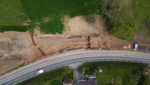
Garranacanty 1 was located on the proposed N74 Ballyhusty Realignment Scheme, near Tipperary town, Co. Tipperary. The site was situated in a pasture field on the north side of the N74.
The excavation, which was carried out on behalf of Tipperary County Council/Transport Infrastructure Ireland, revealed a complex of archaeological features within a narrow strip excavated along the side of the existing road. Two segments of a probable early medieval annular enclosure ditch were exposed and a large ditch is probably a medieval boundary. Several further ditches and linear features were also noted along with pits, possible post-holes and a probable structure.
Following test trenching, an area of 3,200m2 was proposed for excavation, however it was possible, because of the topography and the design of the new road, to preserve part of the site in situ. Much of the central and eastern parts of the site was proposed for preservation in situ, however, it subsequently became apparent that ground conditions were not suitable at the eastern end of the site. For engineering reasons, it was necessary to excavate below the designed formation level for road construction and the features that were left in situ therefore required full archaeological excavation, including features exposed when the road-side embankment was removed. The final area of excavation was approximately 2,903m².
The earliest phase of activity may be early medieval in date and comprises part of a large annular ditched enclosure at the eastern end of the excavation area. Two lengths of the enclosure ditch lay within the excavated site, which exposed a ‘slice’ through its southern half. Groundworks as part of the construction phase along the existing N74 road exposed further parts of the enclosure ditch, showing it to survive beneath the asphalt. As exposed, the enclosure had an internal diameter of approximately 35.25m, with an external diameter of 38.75m. Although the two ditches were not entirely symmetrical, it is likely that these represent part of the southern half of an enclosure with an internal diameter of perhaps 35-38m. The ditches were each 1.7-2.7m wide and 1-2m deep with steep-sided V-shaped profiles. There was limited evidence of an internal bank.
The area surrounding the site has a rich medieval background and features of this period include a very large boundary ditch and several earthen banks, which seemed to form part of a much wider landscape. Clearly visible as earthworks both within and beyond the excavated area, particularly to the north, were large ditch and bank features which appeared to demarcate or delineate divisions within the landscape. Likely functioning as field divisions or territorial boundaries during the medieval period, only small portions of these substantial features were excavated within the road take.
The largest feature recorded during the excavation was a ditch towards the central-western part of the site that was visible as a large north to south aligned earthwork in the field prior to the excavation and can be seen to extend another 920m northwards from the excavated site, connecting with the western edges of moated enclosures (TS067-009001 and -009003) in the neighbouring field en route and continuing at least as far as a small stream. Within the excavated area this ditch was slightly curvilinear in plan and 24.57m long, continuing beyond the limit of the excavation at both the northern and southern ends. The ditch was up to 7.5m wide, with a maximum depth of 2.35m and a steep U-shaped profile. Due to the undulating field surface relative to formation levels for the road development, it was possible to preserve part of this large ditch in situ beneath the formation level of the new road. Therefore much of the ditch was only dug to a depth just below the foundation layers of the proposed road and any associated drainage etc. The ditch was only dug to full depth in one location.
On the western edge of the large boundary ditch was the remnant of what had been a substantial earthen bank, visible as an earthwork in the field to the north. Another large earthen bank, flanked by ditches, forms the eastern boundary of the field in which the site was excavated and this also extends a considerable distance northwards, forming part of the same system of earthworks. Within the site the bank was up to 3.5m wide and stood to a maximum height of 1.3m.
Several phases of post-medieval activity were recorded, largely relating to ditches aligned parallel with the road, which had a distinctive bend at this point. These ditches truncated the earlier features and were themselves truncated by later iterations of this road edge boundary.
Overlying the earliest of these post-medieval ditches were the remnants of a possible building, co-incidentally located in the interior of the earlier enclosure. Very little survived of the structure, which was represented simply by a patch of floor, a hearth and some lines of stones that could be external drains or potentially wall bases. The outline of the building was very poorly defined, however it appeared to extend across a roughly rectangular area measuring approximately 5.85m by 1.85m, being truncated by a later road-edge ditch at the south. At the north the floor was either truncated by or, more likely, defined by a stone-lined drain. This insubstantial dwelling had presumably stood against the edge of the road in the 18th or early 19th century.
DCIM100MEDIADJI_0256.JPG