2022:728 - ROSMEEN: Ballintober Castle, Roscommon
County: Roscommon
Site name: ROSMEEN: Ballintober Castle
Sites and Monuments Record No.: RO027-048002-
Licence number: 15E0232
Author: Niall Brady, The Archaeological Diving Company Ltd.
Author/Organisation Address: Beverley Studios, Church Terrace, Bray, Co. Wicklow
Site type: Castle - Anglo-Norman masonry castle and and Settlement deserted - medieval
Period/Dating: Late Medieval (AD 1100-AD 1599)
ITM: E 572554m, N 774806m
Latitude, Longitude (decimal degrees): 53.722198, -8.415851
A sixth season of excavation and survey took place at Ballintober Castle, Co. Roscommon, RO027-048002-, in 2022 as part of the archaeological and anthropological research and Summer field school project, Castles in Communities, Medieval Ireland Past and Present, and following a two-year hiatus due to COVID-19. The field school is an initiative of the project directors and is funded through Foothill College, California, USA.
Application was made and granted to continue an excavation cutting inside the castle at its main entrance, Cutting 3; to continue the excavation of a property plot within the deserted village in ‘Garvey’s Field’ to the east of the castle in what is officially recorded as a field system (RO027-048014), DS2; and to open a series of hand augur sample locations within the site of the deserted village in Garvey’s Field (SSU1–SSU12).
Application was also made to continue further geophysical survey in the areas immediately surrounding the castle. In addition, field survey continued to expand a field-walking component around the present-day village, and a detailed survey of the graveyard.
The aim of the excavation within the standing castle, C3, which was placed in the original entrance area along the eastern perimeter wall, is twofold. First, C3 is located to reveal elements of the building history of the entrance complex itself; and second, it is located to assess whether this prominent entrance might be a logical and safe place to install a viewing platform into the castle for future generations of visitors. Prior to the cutting being started in 2019, the location was surveyed in detail using Ground Penetrating Radar (GPR). Cutting 3 measures 20m long by 6m wide and is extended along the long axis of the entrance, purposefully chosen to expose the side walls of the entrance towers that define the entrance, and the central path of the entrance itself. Work in 2019 removed the topsoil across the cutting and progress was made at the east end. In 2022, further excavation continued to expose lengths of the corresponding ruined tower walls that are either side of the entrance. The observation made in 2019 that the entrance structure represents at least two phases of construction continues to be observed, and a cobbled surface was recorded in 2022 at a depth of 700mm from the ground level. The cobbled surface slopes from west to east and is incomplete. Further excavation is required to more fully reveal the cobble and to understand its role in the chronological sequence within the entrance area. A number of small finds are associated with the collapse overburden, and include several quernstone fragments. Excavation in the western part of Cutting 3 progresses more slowly and has yet to reveal substantive base layers.
The cutting within the deserted settlement, DS2, which was opened in 2018 was completed in 2022. The cutting opened a narrow section across one of the property plots on the north side of the settlement’s principal roadway. The plots include defined boundary ditches on either side, and a house located between them. The house retains a central hearth. Excavation in 2022 focused on completing examination of the central hearth feature. The work revealed a sequence of substantial hearth deposits that appear to fill a cut which was originally intended to function as a pit. The processing of soil samples from the hearth deposits is underway and it is anticipated that additional samples will be selected for further radiocarbon analysis to provide a more complete chronological record of the house within its property plot.
The series of hand augur samples were conducted across the wider deserted settlement area to address questions associated with considerations on the nature of the settlement and variations in the settlement status across its principal focus area. The archaeological geophysics completed since 2015 have combined overlapping datasets of ground-penetrating radar and magnetometry, which permitted the generation of detailed interpretive maps of the archaeological subsurface. In order to recover buried archaeological samples suitable for radiocarbon and micro-botanical and chemical analyses, the programme of hand augur samples was devised as a means to achieve a more complete archaeological survey of the buried landscape with minimal intrusive intervention. Twelve Sub Surface Unit (SSU) samples were completed and preliminary results are acquired.
Geophysical survey in 2022 comprised Ground Penetrating Radar, and continued to focus on filling in gaps in the datasets acquired already in the fields east of the present-day village. The substantial data continues to reveal the nature of occupation and settlement around the castle and the present-day village and suggests questions of further enquiry that deal with the reasons for settlement origins and contraction.
The programme of walkover field survey that forms part of the wider field school project continues to examine the landscape within the deserted settlement and beyond, reaching ever further away from the village and observing a series of discrete features that might be archaeological in nature.
Detailed topographic survey of the graveyard in Ballintober was conducted for the village community.A sixth season of excavation and survey took place at Ballintober Castle, Co. Roscommon, RO027-048002-, in 2022 as part of the archaeological and anthropological research and Summer field school project, Castles in Communities, Medieval Ireland Past and Present, and following a two-year hiatus due to COVID-19. The field school is an initiative of the project directors and is funded through Foothill College, California, USA.
Application was made and granted to continue an excavation cutting inside the castle at its main entrance, Cutting 3; to continue the excavation of a property plot within the deserted village in ‘Garvey’s Field’ to the east of the castle in what is officially recorded as a field system (RO027-048014), DS2; and to open a series of hand augur sample locations within the site of the deserted village in Garvey’s Field (SSU1–SSU12).
Application was also made to continue further geophysical survey in the areas immediately surrounding the castle. In addition, field survey continued to expand a field-walking component around the present-day village, and a detailed survey of the graveyard.
The aim of the excavation within the standing castle, C3, which was placed in the original entrance area along the eastern perimeter wall, is twofold. First, C3 is located to reveal elements of the building history of the entrance complex itself; and second, it is located to assess whether this prominent entrance might be a logical and safe place to install a viewing platform into the castle for future generations of visitors. Prior to the cutting being started in 2019, the location was surveyed in detail using Ground Penetrating Radar (GPR). Cutting 3 measures 20m long by 6m wide and is extended along the long axis of the entrance, purposefully chosen to expose the side walls of the entrance towers that define the entrance, and the central path of the entrance itself. Work in 2019 removed the topsoil across the cutting and progress was made at the east end. In 2022, further excavation continued to expose lengths of the corresponding ruined tower walls that are either side of the entrance. The observation made in 2019 that the entrance structure represents at least two phases of construction continues to be observed, and a cobbled surface was recorded in 2022 at a depth of 700mm from the ground level. The cobbled surface slopes from west to east and is incomplete. Further excavation is required to more fully reveal the cobble and to understand its role in the chronological sequence within the entrance area. A number of small finds are associated with the collapse overburden, and include several quernstone fragments. Excavation in the western part of Cutting 3 progresses more slowly and has yet to reveal substantive base layers.
The cutting within the deserted settlement, DS2, which was opened in 2018, was completed in 2022. The cutting opened a narrow section across one of the property plots on the north side of the settlement’s principal roadway. The plots include defined boundary ditches on either side, and a house located between them. The house retains a central hearth. Excavation in 2022 focused on completing examination of the central hearth feature. The work revealed a sequence of substantial hearth deposits that appear to fill a cut which was originally intended to function as a pit. The processing of soil samples from the hearth deposits is underway and it is anticipated that additional samples will be selected for further radiocarbon analysis to provide a more complete chronological record of the house within its property plot.
The series of hand augur samples were conducted across the wider deserted settlement area to address questions associated with considerations on the nature of the settlement and variations in the settlement status across its principal focus area. The archaeological geophysics completed since 2015 have combined overlapping datasets of ground-penetrating radar and magnetometry, which permitted the generation of detailed interpretive maps of the archaeological subsurface. In order to recover buried archaeological samples suitable for radiocarbon and micro-botanical and chemical analyses, the programme of hand augur samples was devised as a means to achieve a more complete archaeological survey of the buried landscape with minimal intrusive intervention. Twelve Sub Surface Unit (SSU) samples were completed and preliminary results are acquired.
Geophysical survey in 2022 comprised Ground Penetrating Radar, and continued to focus on filling in gaps in the datasets acquired already in the fields east of the present-day village. The substantial data continues to reveal the nature of occupation and settlement around the castle and the present-day village and suggests questions of further enquiry that deal with the reasons for settlement origins and contraction.
The programme of walkover field survey that forms part of the wider field school project continues to examine the landscape within the deserted settlement and beyond, reaching ever further away from the village and observing a series of discrete features that might be archaeological in nature.
Detailed topographic survey of the graveyard in Ballintober was conducted for the village community.
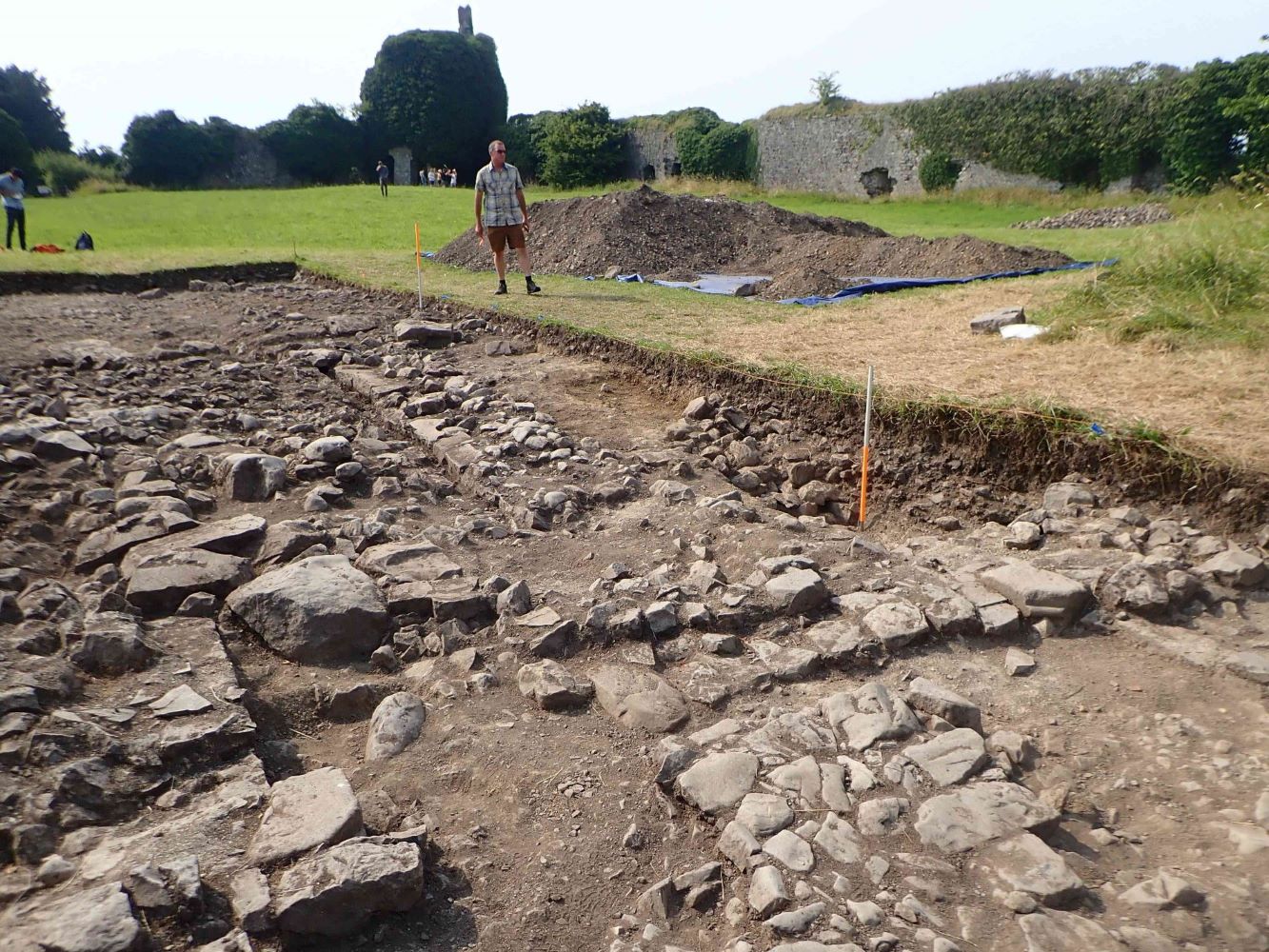
Photo caption: Ballintober Castle excavation 2022, showing Cutting 3 across the castle entrance and emerging wall bases and cobbled surface.