2022:277 - CASTLE ISLAND, Roscommon
County: Roscommon
Site name: CASTLE ISLAND
Sites and Monuments Record No.: RO006-046001
Licence number: E0005408
Author: Thomas Finan
Author/Organisation Address: thomas.finan@slu.edu
Site type: Castle - tower house
Period/Dating: Late Medieval (AD 1100-AD 1599)
ITM: E 584740m, N 804493m
Latitude, Longitude (decimal degrees): 53.989467, -8.232691
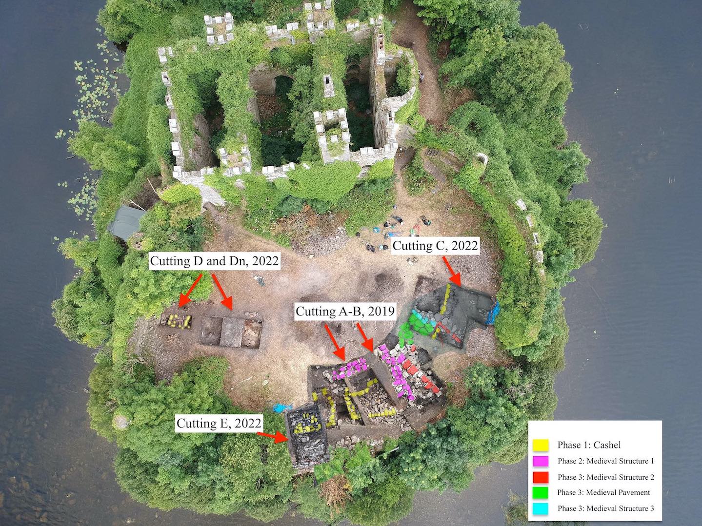
Excavations continued on Castle Island, County Roscommon, in the summer of 2022. The site, also known as the Rock of Lough Key or MacDermot’s Rock, was the main caput of the McDermot lords of Moylurg throughout the medieval period. Excavations in 2019 revealed a cashel of likely early medieval date, with several buildings of high medieval date. Artifacts included a number of classic thirteenth-century high status items like dress pins, gaming pieces, and imported pottery.
The two main goals of the 2022 excavation were to identify a relationship between the modern enclosure wall surrounding the island and the earlier cashel wall, and to more fully discern the high medieval buildings and remains on the island. Three cuttings were opened, two in proximity to the cuttings from 2019 (C and E) and one more removed to the east (cutting D).
In Cutting C, additional walls related to “Building 2” from 2019 were identified, as well as two hearths or furnaces. Additionally, the walls identified as part of Building 2 were constructed on top of remains of the cashel wall identified in 2019; this provided conclusive evidence that the cashel wall did in fact continue on the island, and that this cashel preceded the high medieval remains. Artifacts found included a collection of bone harp pins, silver pins, gaming pieces, and two finely etched “test pieces” carved on cattle rib. The two walls identified as part of “Building 2” measured 5m within the trench, and likely continue to the north. The wall was two to three courses high, and composed of flat squarish stone of 0.4-0.5m. Evidence of mortar was found within the joints of the stone. One of the walls appeared to be an extension of an earlier wall, and was built upon a surface of very large flagstones, measuring up to 0.8m in circumference.
In 2019 an extensive layer of burned material was located below the buildings but on top of the cashel; this layer was also found in Cutting C. An extensive collection of butchered animal bone was recovered from this context. An extension was continued to the extant wall. A 19th-century construction trench was noted, dipping down to a depth of around 0.3m. This trench led to the extant wall, at which point a large amount of mortar was found. The mortar seems to have been inserted into the fabric of the wall, but a great deal of it had eroded.
A number of furnaces were found in Cutting D. The soil in the furnaces was a bright orange to white compacted clay with a heavy amount of ash; the ash layers were probably multiple burnings in the same furnace. Little evidence of actual material from the furnace was recovered. An extension to the north was made to connect this cutting to the extant wall. The cashel wall was identified in this extension. The baulk between Dn and D was removed, exposing a deposit underneath the cashel wall composed of a silty brown soil and rubble; animal bone samples were collected from this layer. A coin tentatively identified as a penny from John I was found in the fill outside the wall. The topsoil and layer immediately beneath the topsoil showed signs of 19th-century gardening, with a collection of around thirty fragments of clay pipes. A heavy layer of mortar was inserted into the extant wall roughly 0.2m below the surface; this was interpreted as a 19th-century attempt to fortify the wall.
Cutting E was opened as a continuation of Cutting A in order to test the relationship between the cashel wall and the extant wall. The cashel wall was again identified, with a rubble fill between the cashel and extant wall. The instability of the extant wall prevented further excavation at this point.