2022:814 - BETTYSTOWN: Seaview Terrace, Mornington, Meath
County: Meath
Site name: BETTYSTOWN: Seaview Terrace, Mornington
Sites and Monuments Record No.: N/A
Licence number: 22E0259
Author: Niall Roycroft
Author/Organisation Address: C/o Meath County Council
Site type: Excavation - miscellaneous
Period/Dating: Undetermined
ITM: E 715970m, N 773551m
Latitude, Longitude (decimal degrees): 53.698768, -6.243765
Meath County Council (MCC) developed a site at Seaview Terrace in Mornington townland at Bettystown, Co. Meath as a civic amenity. The site is roughly 1,000 sq. m. The standing buildings were recorded and demolished in September 2022. The ground level was then slightly reduced, but still reflected the sloping present ground level of around 4.2m OD at the western streetscape down to around 2.9m OD as part of Bettystown beach. From this level, four large test-pits (EX1-4) and four underpinning lengths (EX5-8) were dug. In addition, a section (EX9) on the north-east side was investigated. These works are combined with advance site investigation works (BH1-2; WS1-6; TP1-4).
19th-century prints, mapping and photographs show that the Seaview Terrace road was a beach access track that seems to have once been associated with a form of quay and a loading crane. No evidence for this was found. However, this quay was associated with a stream which ran across the tidal beach to the sea. This stream would have provided access to boats moored off-shore near to a fixed sea-light. In the mid-19th century, this stream seems to have been diverted to provide water to the Neptune Hotel. This stream is not marked on the 1650’s Down Survey or 1817 Larkin Map, but it marks the drainage from the higher ground to the north-north-west that formed a back-dune marsh zone now occupied by the lands to the west of the Golf Links Road. This stream seems to have been part of a broader, wetland ‘salt-march’ zone under the Seaview Terrace site, which formed the then-north-east boundary to the broad, higher knoll (up to 8.5m OD) of ancient Bettystown, that forms the archaeological focus from 3500BC onwards.
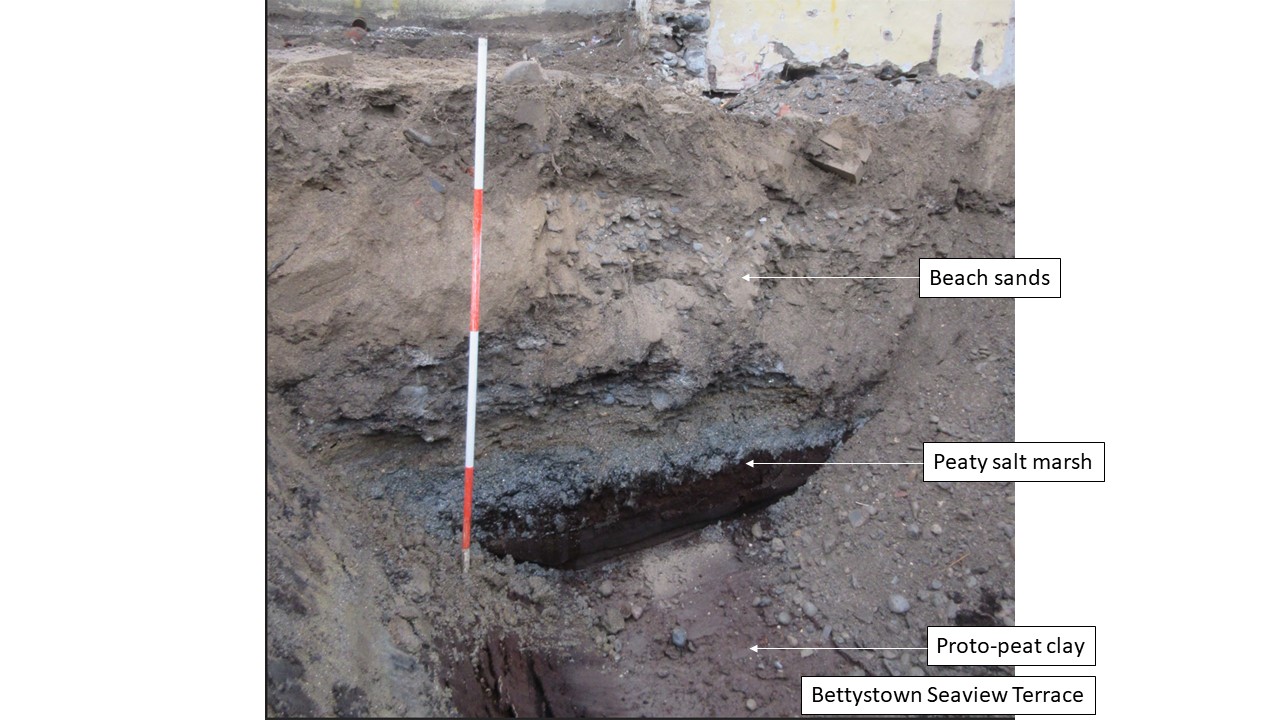
The final phases of the ‘salt-march’ organic clays and peaty marshes of the Seaview Terrace perhaps date to the later-18th to early-19th century and are currently buried beneath beach sands and small gravels. These marshy deposits are focussed on the west-south-west side of the site. Elsewhere, the beach sands cover further sandy bars and clay-filled channels (also containing organic material), which could be of any date.
Probable glacial till (stained black) was seen in BH1 at 0m OD and BH2 at -1.3m OD. These levels perhaps reflect marginal land bordering a tidal inlet. Above is a dark grey-green and blue salt-marsh deposit that is capped with mid-brown, dried proto-peat organic clay and silts. The ‘marsh’ deposits vary from 0.5m to 2.2m deep and perhaps reflect shifting inter-tidal bars and channels. The organic clays are then covered with beach sands 1.8m to 2.1m deep, which ultimately formed a more stony and gritty ‘top-of-the-beach’ deposit (containing numerous seashells), upon which the Seaview Terrace houses were built in the mid to late 19th century.
Seaview Terrace occupation was seen by modern pottery, food waste (including large deposits of seashells and animal bones) numerous nails and large iron objects. One deposit with food waste contained two George V (1910-1936) one penny coins (highly corroded).