2022:669 - NAVAN: Local Distributor Road 4, Blackwater Park, Meath
County: Meath
Site name: NAVAN: Local Distributor Road 4, Blackwater Park
Sites and Monuments Record No.: N/A
Licence number: 22E0366
Author: Niall Roycroft
Author/Organisation Address: C/o Meath County Council
Site type: Excavation - miscellaneous
Period/Dating: Multi-period
ITM: E 686018m, N 768357m
Latitude, Longitude (decimal degrees): 53.657895, -6.698642
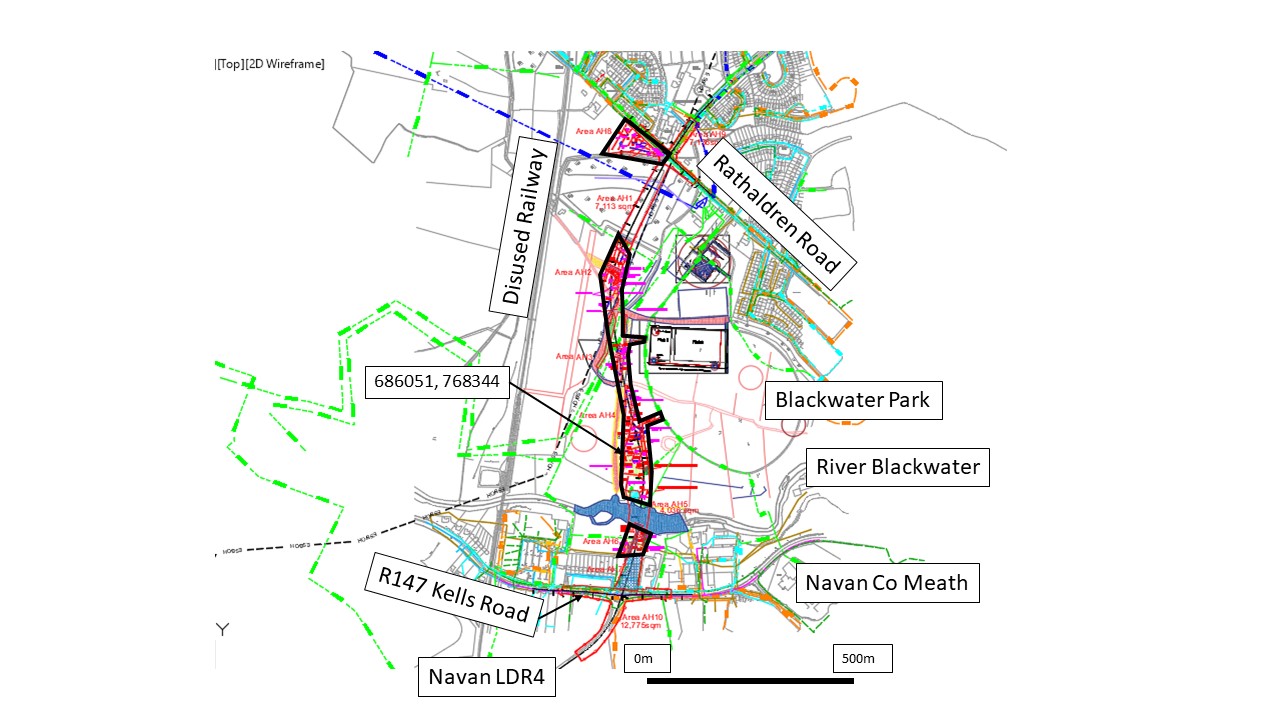
Meath County Council is proposing to construct the Local Distributor Road No. 4 (LDR4) on the north-west side of Navan, Co Meath. The LDR4 is to be around 1.15km long and comprises approx. 6.9 hectares (ha) of which 3.4ha is green field lands, 0.7ha was unavailable at this time (forestry) and 2.8ha is already disturbed and tie-ins. The centre point is ITM: 686018, 768357 with the road as roughly 165m on the south side of the River Blackwater and approx. 900m on the northern side. The River Blackwater is a Special Area of Conservation and the modern flood plain zone is not due to be impacted by the development.
LDR4 lies approx. 170m west of an early medieval ringfort and field system, and also roughly 75m west of a Bronze Age/Iron Age ring ditch, as well as c.75m west of some 19th-century inhumation burials associated with a nearby farm shown on the 1837 OS map. The above archaeology was recorded as 12E0103 during the construction of Blackwater Park.
Archaeological testing took place in June and November 2022. From north to south, Area 8 by the Rathaldren Road showed field drainage ditches and a series of parallel furrows. In the corner, next to a ruined shed, was a tumbled farmyard wall and an area of hard standing.
Area 1 comprised a forestry area and was not available for testing.
Area 2 showed a large field drain, parallel furrows and a c. 35m east-west length (indicated by trenches) of the original Navan to Donaghpatrick (Rathaldren) Road that is shown on the 1837 OS map. The Road is 3m wide with drainage gutters and roadside ditches probably defining grassed verges. There is a dog-leg bend that is shown on the 1837 mapping. But to the south of this point the road structures seem to have been completely ploughed away. A later trackway realignment seen on mapping had also been entirely truncated. This road is the same as an intact length of the road that still exists in a hedgerow to the east of the proposed LDR4.
Area 3 showed three parallel east-west ditches each located roughly 10m apart. These probably go with a post-medieval field system for the nearby farms shown on the 1837 OS map. Also in Area 3 was a scorched area of natural clay for a pit-oven or a burnt-out tree bole that had been completely ploughed away.
Area 4 showed a post-medieval field system with extensive remains of boundary and plot ditches and furrows being noted, indicating two main fields. In the corner next to one of these field ditches was a 1m diameter pit-oven or charcoal starter pit. This pit was only 0.15m deep due to plough truncation. It was fully excavated as it was too insubstantial to re-bury. Most of the larger field ditches had been picked up in the Earthsound Geophysical Survey 19R0127. This survey also noted anomalies that turned out to be patches of natural gravels in the more sandy natural drift. Towards the River Blackwater there was a deposit of ore-rich rocks and a nearby (open) quarry marked on the 1837 OS map, which may have been dug to extract these ores.
On the southern side of the River Blackwater, post-medieval topsoil was noted near to the river and part of a masonry ha-ha runs along the line of a historic boundary and possible field track to Mill Brook house (mostly demolished). There was also extensive dumping and truncation associated with the construction of the former OPW building in this area.
The archaeological testing comprised roughly 10% of the available green field areas. From the results of the testing it is recommended that the LDR4 development goes ahead with an archaeological monitoring condition for all topsoil stripping. With human remains having bee found in the area it cannot be certain that no more burials might be found. Apart from this, the field system and road give a low potential for archaeological remains.