2022:665 - KENNEDY ROAD, KENNEDY PLAZA AND ABBEY ROAD, Townparks North, Navan, Meath
County: Meath
Site name: KENNEDY ROAD, KENNEDY PLAZA AND ABBEY ROAD, Townparks North, Navan
Sites and Monuments Record No.: ME025-044---
Licence number: 19E0519 ext.
Author: Niall Roycroft
Author/Organisation Address: C/o Meath County Council
Site type: Town
Period/Dating: Post Medieval (AD 1600-AD 1750)
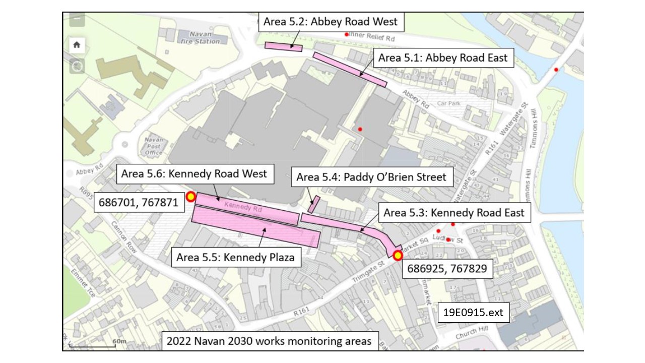
ITM: E 686701m, N 767871m
Latitude, Longitude (decimal degrees): 53.653416, -6.688448
2022 Services works in Kennedy Road, Kennedy Plaza and Abbey Road, Navan (ITM: 686701, 767871 to 686925, 767809, Navan Townparks) consisted of several trenches totalling approx. 300m long up to 1.5m deep. Although the presumed Town Defences were not found, their line was marked in footpath cobbles in the area of the Kennedy Road/Paddy O’Brien Street junction.
The works were generally quite limited with the main area being Kennedy Road which was given Chainage (Ch) Kennedy (K) Ch000-120. This is the area of the Preston School that was rebuilt in 1829 and demolished in the 1970s. The Kennedy Plaza works in the area of the ‘Town Defences’ (seen by a 6.5m wide ditch (C000178, E2905, Eoin Corcoran) did not descend beyond levels truncated when the 2007 Plaza was laid out. The works were archaeological monitored for Meath County Council from August 2022 to January 2023.
The whole area had been horizontally truncated by the 1970’s creation of Kennedy Road and the original ‘Kennedy Plaza’ as well as other more recent developments. As such, only a few deep-cut features were recorded.
PHASE 1: NATURAL SANDS, SILTS, GRAVELS AND OCCASIONAL COBBLES
Natural strata were seen from the middle of Kennedy Road (KCh40) as far as Trimgate Street (KCh120). These were light yellow brown silty sands to the west (KCh43 = 44.25m OD to KCh70 = 44.05m OD), a bank of sands and gravels at KCh80-KCh105 (All at 44.50m OD) and then back to sands at Trimgate Street (KCh44.2m OD).
PHASE 2: CUT FEATURES AND TRIMGATE ROAD
A c.1.2m diameter barrel well or soakaway was located at KCh60 (686874, 767845) at the junction with the lane to the Arc Cinema. This was only partly exposed and partly excavated and remains undated. A large post-medieval quarry pit was located at KCh000-KCh040 (base below limit of excavation). This contained red brick and clay tobacco pipe stems and was probably associated with the Preston School development of c. 1829. Another probable quarry pit was located at KCh90 with a second pit or cut truncating it. Again these features seem to be post-medieval in date. Finally, there was a tiny patch of gravels seen in Trimgate Street directly underneath the modern tarmac and this gravel was taken to be the previous gravel road. The deposit was so slight that it had either been horizontally truncated or it dated to the fairly recent past.
PHASE 3: PRESTON SCHOOL 1829
The demolished remains of the Preston/Charter School House (rebuilt 1829 according to Navan Historical Society records and demolished in the 1970s) were seen by several walls in the area of 686850, 767850 to 686879, 767841 (KCh35 – KCh67). The school itself was outside the area of the excavation with remains extending into the middle of present Kennedy Road, but two light wells were revealed.
Mapping shows the school building to be H-shaped (max. 26.5m long x 13.5m wide) oriented east-west with the end blocks being 7.5m x 13.5m and the central section being 11m x 8.5m. There was a large, three-bay, formal ‘Main’ façade facing west with a central set of steps to the garden and a turning sweep for carriages, and there was a second entrance in the middle of the north side (where there was no light well). Around the time of building in 1829, the school actually moved to Ardbraccan (although named as ‘Charter School House’ on the 1837 OS) and the building is named ‘Rectory’ on the 1895 mapping. However, the ‘Preston School’ presumably moved back here in the early 20th century.
PHASE 4: PRESTON SCHOOL DEMOLITION, CREATION OF KENNEDY ROAD, PADDY O’BRIEN STREET AND KENNEDY PLAZA AND WIDENING OF ABBEY ROAD
In the 1970s Preston School was demolished (and the basements infilled with rubble) and the present Kennedy Road was laid out. At this time the whole of the Kennedy Road area was reduced to natural strata or stable deposits and the area of the Kennedy Road-Paddy O’Brien Street junction was raised by up to 1.5-2m, to vertically realign the new road. The walls along the line of the Navan Town Wall (as labelled by Williams on the 1756 map) were generally retained in the area through the 1980s, and by 1995 the PTSB building at the Kennedy-O’Brien junction had been constructed. However, the PTSB building was built so that it floated above the earlier wall remains (which were also buttressed with mass concrete). Remains of this earlier wall still survive and they are on a slightly different alignment to the PTSB wall. Beyond this section there is a stump from a 19th-century garden wall that has been retained at the entrance to the adjacent multi-story carpark. However, when the P. O’Brien Street carpark was built in the 1990s, the wall along the line of the Town Wall was removed.
Kennedy Plaza began as a carpark in the 1970s and was formally laid out in a terraced manner in the 1980s. In 2007 it was redesigned as Kennedy Plaza. These works involved the reduction of the whole area to natural strata and in 2007 a 6.5m wide (C000178, E2905, Eoin Corcoran) possible town ditch on the line of the ‘Town Walls’ was noted in archaeological testing. This ditch was not relocated in the 2007 works and no new features were revealed.
Works in Abbey Road showed that the present Abbey Road is roughly twice as wide as it was in the early 1970s. Until that time there was a roadside boundary wall on the south side as seen from photographs and mapping and this wall was noted in the middle of the present street. Nothing else that was not completely modern was revealed in the Abbey Road works.