2022:664 - KELLS: The Sawmills – Rear of 5-6 Church Hill, Meath
County: Meath
Site name: KELLS: The Sawmills – Rear of 5-6 Church Hill
Sites and Monuments Record No.: ME017-044---
Licence number: 22E0709
Author: Niall Roycroft
Author/Organisation Address: C/o Meath County Council
Site type: Town
Period/Dating: Modern (AD 1750-AD 2000)
ITM: E 674004m, N 775957m
Latitude, Longitude (decimal degrees): 53.728016, -6.878546
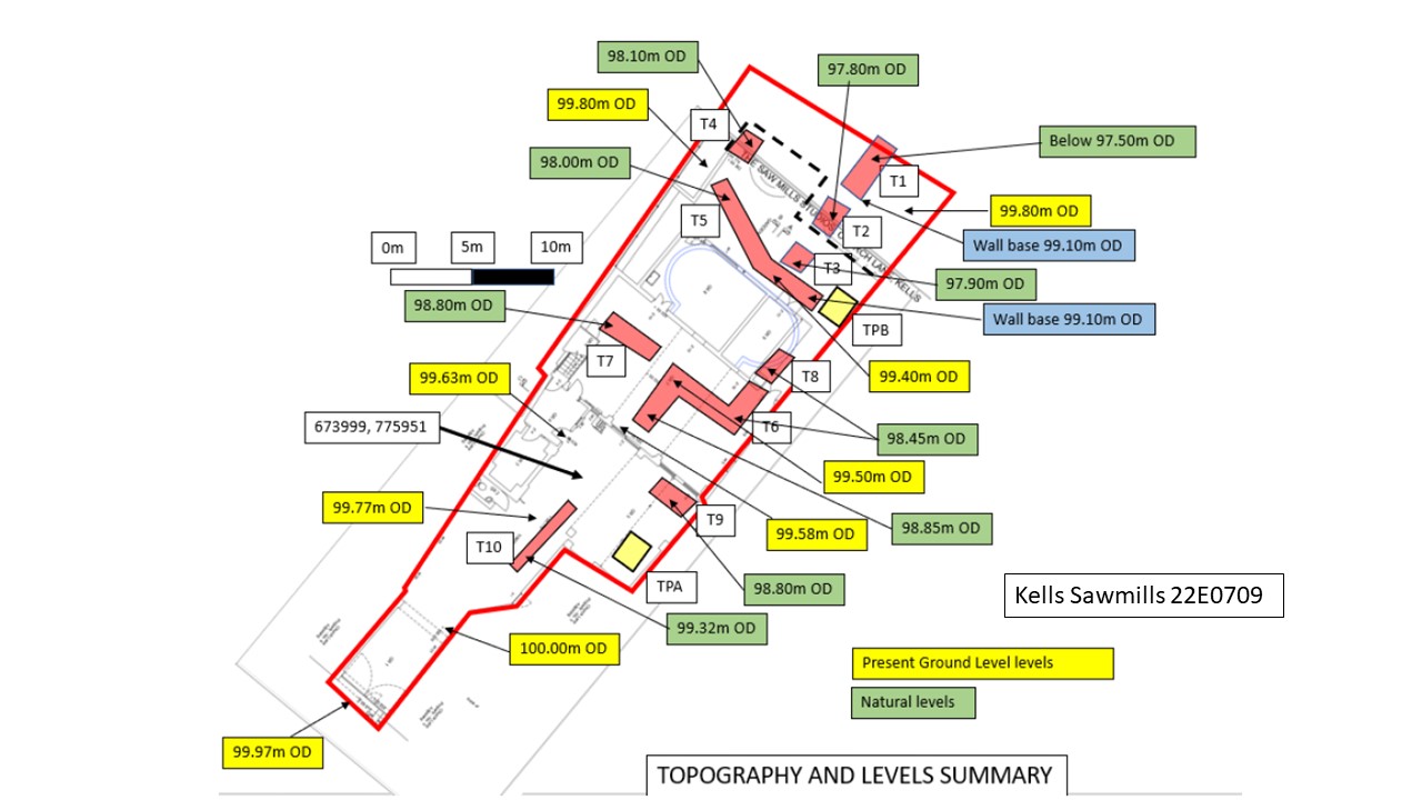
Archaeological testing took place at the Sawmills, Rear of 5-6 Church Hill, Kells, Co. Meath (site area is approx. 467 sq m of which 200 sq m are standing buildings). The testing was completed on behalf of Meath County Council on 8 and 9 September 2022.
The aim of the test excavation was to determine the location, date, nature and extent of any archaeological features and/or deposits that may exist within the site. Ten trenches totalling 62.66 sq m (approx. 13% of the site area) were excavated using a 1 tonne micro-digger in and around the standing buildings. The results showed natural glacial drift sloping from 99.32m OD near to Church Hill to 97.5m OD at the northern end of the site (a distance of approx. 45m).
At the Church Hill/entrance yard end, a surviving area of post-medieval cobbled yard surface set onto glacial drift had been cut by all the services entering the site. In all other trenches glacial drift was directly overlain by a lower and upper ploughsoil from 0.6m to 1m deep consisting of dark grey-brown silty clay that contained post-medieval/modern pottery throughout. This area is shown as Glebe lands on 18th-century mapping of Kells.
The site is shown as containing street-frontage buildings (probably a through-arch-access as at present) and a rear ‘office’ on the 1837 OS. The yard surface and two ‘back-plot’ pits may go with this phase. Much of the site is shown with industrial ‘Sawmills’ buildings on the c.1900 25-inch map. However, these were all demolished, replaced and extended by the 1939 Cassini map. The site was also levelled up with imported soils and rubble at this time. Since then, the buildings have been reduced to the main, two-story mass concrete building (which sometimes reused previous building foundations, is sometimes built on previous garden boundary walls and had new concrete foundations where there were gaps) and some late 20th-century concrete-block built, single-story extension replacements. A tarmac yard surface overlies the earlier cobbled yard.
A large, stone-built late 19th-century box drain was located, but this seems to begin on the edge of the site and the inflow-gully has been replaced with modern plastic drainage pipes.
The proposed development is to retain the existing two-story building but to reinforce its walls with vertical girders that have associated, concrete foundations. The main impact will be to drop the existing floor level of the main building ground floor by around 1m (to glacial drift level) to allow for services and also height for the proposed printing presses to be set here. The existing single-story extensions will be demolished and mostly rebuilt in the same general area with new foundations. Many of the existing services can be reused although some new runs are predicted.