2022:179 - ASHBOURNE: Balrasna and Milltown, Meath
County: Meath
Site name: ASHBOURNE: Balrasna and Milltown
Sites and Monuments Record No.: N/A
Licence number: 22E0590
Author: Steven McGlade, Archaeology Plan
Author/Organisation Address: 32 Fitzwilliam Place, Dublin 2
Site type: Excavation - miscellaneous
Period/Dating: Prehistoric (12700 BC-AD 400)
ITM: E 706415m, N 751345m
Latitude, Longitude (decimal degrees): 53.501325, -6.395976
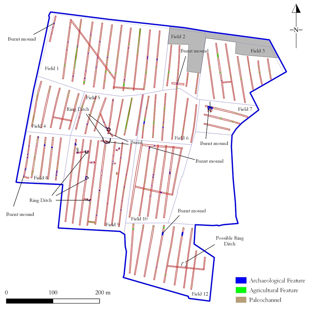
An extensive programme of archaeological test-trenching was carried out in Baltrasna and Milltown townlands, Ashbourne, Co. Meath, which identified a number of features of archaeological interest. The site had previously been subject to a geophysical survey (Leigh & Curran, 22R0015).
Five ring-ditches were identified, two of which were associated with extended burials. The largest ring-ditch had a diameter of c. 13m and was truncated to the north by a field boundary ditch. An in-situ human burial, which appeared to be extended, supine and orientated east-west, was identified within the interior of the ring-ditch in the south-east quadrant. Additional ex-situ human remains were noted in the field boundary bank between Fields 5 and 9 suggesting the digging of the ditch and creation of the bank had disturbed at least one more burial. To the north of this a smaller ring-ditch measuring c. 6.1m in diameter was identified. Two additional burials were identified to the south of the northern ring-ditch, possibly originally being within the associated external bank. The burials appeared to have been extended, supine and orientated east-west, though the majority of the burials lay beyond the line of the trench. One of the burials may have had a partial stone lining.
Three additional ring-ditches were identified further to the south. To the south-west of the largest ring-ditch a c. 4.5m diameter ring-ditch was uncovered. A pit was identified in the interior of the ring-ditch. No charcoal or burnt bone was noted within the fill of the ring-ditch or the pit, though a pit to the east contained burnt clay and charcoal. Based on form this may also represent a burial monument. A number of additional features were identified in the vicinity of the ring-ditch. Further to the south a c. 4.7m diameter ring-ditch was identified. The interior of the ring-ditch was not investigated, though occasional burnt bone was noted in its upper fill suggesting it is also likely to be a burial monument. Another feature identified to the south may represent a penannular ring-ditch c. 4.5m in diameter with an opening to the north. The form of the ditch was different to that of the other ring-ditches encountered, being broad and shallow in the section investigated. This may not be a burial monument and requires further investigation.
In the southern field an additional circular anomaly was tentatively identified as a ring-ditch. Unfortunately this feature was missed during the testing programme, however it potentially survives within the site. It was close to a burnt mound site and to an area of possible human interaction with a paleochannel.
The two ring-ditches associated with extended inhumations are somewhat unusual in an Irish context. A fragment of metallurgical waste and a probable iron nail were retrieved from the ditch defining the largest ring-ditch suggesting the ditch was open during the Iron Age or later. These may be burial monuments dating to the latter part of the prehistoric period that were reused during the early medieval period. It is possible that the largest ring-ditch was a ferta or ancestral burial place. The ring-ditches are located in a cluster on the southern side of a townland and parish boundary ditch with the largest example located on the highest point within the proposed development site. The prominent location of the ring-ditch also lends to the suggestion that it may have served as a boundary marker.
Pits, post-holes and hearths were identified in the vicinity of the ring-ditches suggesting settlement was taking place nearby. One arc of post-holes was suggestive of a possible structure. An ironworking furnace was also present indicating small-scale industrial activity was also taking place. Two metalled trackways of unknown date were also identified. While these may be of more recent date it is possible they are contemporary with the settlement and burial activity.
Elsewhere within the site a number of former stream courses or paleochannels were identified along with an area of former wetland to the north-east. Possible human interaction was recorded associated with one of the former streams to the south with a number of possible wooden uprights identified along the base of one side of the channel. This may have been a fence-line used to secure or stabilise the side of the stream, or may have been another man-made feature, such as a fish trap or weir. It was not possible to further investigate the timbers during the testing due to the depth of the former channel.
Three burnt mound sites were identified during the testing programme in the vicinity of the former streams and wetlands. Further spreads of possible burnt mound material were recorded in a further three locations, however it was unclear whether these related to burnt mounds or were midden waste from an as yet unknown activity.
Additional sporadic activity was noted to the north-west in the vicinity of the former stream courses and may represent small-scale interactions with this wetland environment.
A number of further mitigation measures have been recommended including monitoring and excavation.