2022:157 - NAVAN 2030 SERVICES, ROAD and FOOTPATH WORKS OF 2022: N51 Park and Ride facility, Townparks North, Navan, Meath
County: Meath
Site name: NAVAN 2030 SERVICES, ROAD and FOOTPATH WORKS OF 2022: N51 Park and Ride facility, Townparks North, Navan
Sites and Monuments Record No.: ME025-023
Licence number: 19E0519
Author: Niall Roycroft
Author/Organisation Address: c/o Meath County Council
Site type: Excavation - miscellaneous
Period/Dating: Multi-period
ITM: E 685943m, N 767799m
Latitude, Longitude (decimal degrees): 53.652894, -6.699931
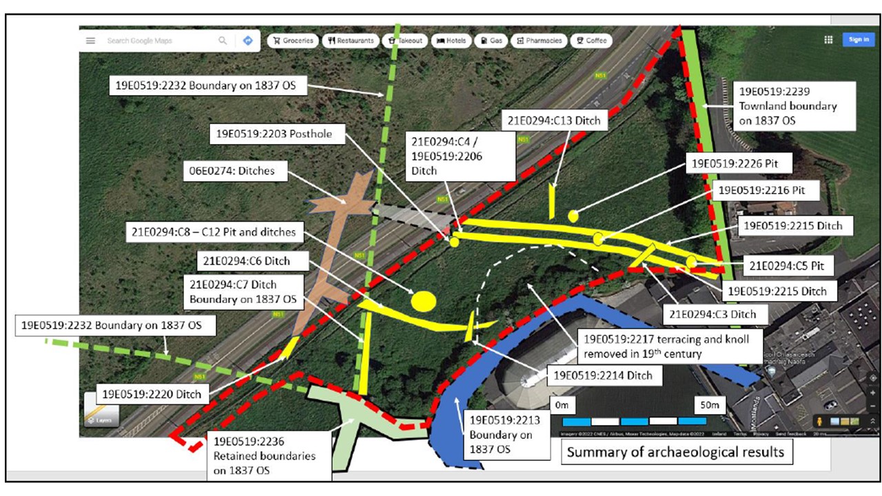
2022 N51 Park and Ride construction phase monitoring at Navan Moathill, partly within the Notification Zone for Motte and Bailey ME025-023, took place from April to July 2022 with a centre point at ITM 685943, 767799 and with an area of approx. 8,750 sq m. The works were monitored under Licence 19E0519 (ext.) for Meath County Council. (19E0519 Area 1 = Railway Street 2019; Area 2= Bridge Street 2020; Area 3 = Ludlow Street 2021; Area 4 = Moathill 2022).
Previous works on the N51 Park and Ride site were:
• Trial pits in 2018 were monitored as 18E0571 (Archer Heritage)
• A Geophysical Survey in 2019 was completed as 19R0127 (Earthsound Ltd)
• The site was thoroughly trial trenched in 2021 as 21E0294 (ACSU Ltd) which identified significant 18th-19th-century terracing and an early modern a field system.
The works were also adjacent to archaeological excavation 06E074 (Archtech Ltd) and near to excavation 06E0024, testing 21E0089 (N Roycroft) and 1997 testing 97E0101. Nearby Geophysical Survey 16R0036 (Leigh) in the housing estate (Sonbrook Property) being constructed opposite the N51 Park and Ride site was obscured by redeposited soils from the original 2006-7 N51 construction. IAC Ltd recommended monitoring topsoil stripping for that site, but it is not currently known if anything was found here.
The N51 Park and Ride was designed to have minimal impact given that there was 0.6m depth of topsoil recorded over the whole site.
However, since the site was sloping, some landscaping was required. The design showed around 2,000sqm of construction works significantly cut into natural soils. A further 1,000sqm of this area had already been previously terraced well into natural (although the bases of some large, deep ditches were seen). Roughly 3,300sq m was dug roughly or slightly into the top level of the glacial subsoils, allowing the field system and deep pits on the site to be retained in situ. Roughly 700sq m had topsoil retained on site so it is not known if there are any archaeological remains beneath those levels. Approximately 1,400sq m was used for landscaping excess soils around the west and south sides of the site. A further 100m comprised works inside the previous 2007 N51 construction area.
PHASE 1: NATURAL SANDS, SILTS, GRAVELS AND OCCASIONAL COBBLES
There are several types of natural deposits on the site. The main body of the Moathill ‘hill’ seems to comprise a large deposit of greyish-brown sands, gravels and cobbles. This is the material that the later quarry focused on extracting. Other parts of the hill comprise soft, clean, yellow-brown sands and the lower levels of the hill seem to be comprised of heavy glacial clays. The west area along the N51 showed some post-glacial cryoturbation features formed by freeze-thaw action. These sands and gravels were covered in a ‘brickearth’ type (windblow silty clay loess) deposit.
PHASE 2: PITS AND A POST-HOLE
The 2022 monitoring noted one post-hole and two pits cut into a natural brickearth-type silty sandy clay in Area 4: Moathill Monitoring 3.
• Post-hole 0.32m wide x 0.4m deep. Base is rounded 0.22m probably in diameter: partly preserved in situ.
• Pit with some burnt material, c. 2.5m x 2m and oval-shaped. It contains chunks of stone and occasional burnt black stones. A small sondage showed that the base was not scorched, but it is possible this was a pit connected with a cereal-drying kiln. Base preserved in situ.
• Circular Pit 0.75m in diameter, round-bottomed (probably) with scorched base and charcoal. Only minimal remains left in situ. Appears to be a typical charcoal, cooking or cereal-drying pit. Base preserved in situ.
Two further pits are described under testing 21E0294 which were preserved in situ.
These are archaeological features, but they remain undated and could be a mix of early, later and post-medieval in date. There was no evidence for a souterrain or any significant clusters of features.
PHASE 3 FIELD SYSTEM
The field ditches seem to comprise a post-medieval field system that was later altered into the field system seen on the 1837 OS map. The field system showed occasional animal bone in the fills, but these are probably to do with disposing of animals that die in a field or manuring rather than occupation/settlement food waste. One boundary was a pair of parallel ditches running east-west across the site; presumably there was a bank between them. This might have been a townland boundary that was realigned to the present Moathill-Townparks boundary that was retained as running down the east side of the site.