2022:502 - DRUMSHALLON, Louth
County: Louth
Site name: DRUMSHALLON
Sites and Monuments Record No.: N/A
Licence number: 22E0655
Author: Fergal Murtagh, c/o IAC Archaeology
Author/Organisation Address: Unit G1 Network Enterprise Park, Kilcoole, Co. Wicklow
Site type: Pit
Period/Dating: Prehistoric (12700 BC-AD 400)
ITM: E 708175m, N 783971m
Latitude, Longitude (decimal degrees): 53.794039, -6.358111
The assessment was undertaken at Gallstown Quarry, Grangebellew, Drumshallon, Co. Louth. It follows a geophysical report carried out by Ger Dowling in June 2022.
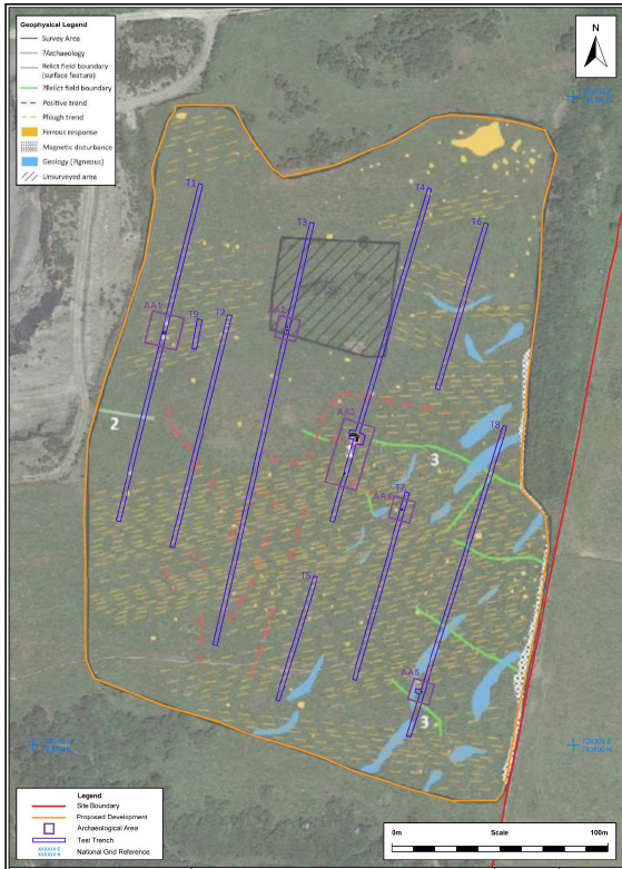
Archaeological testing was carried out over two days from 27 September 2022. Testing revealed five areas of archaeological significance, which have been designated as Archaeological Areas 1–5. These comprise:
• AA1: A spread of dark-brown sandy silt measuring 1.5m wide and 0.06m deep. A sub-circular pit or possible hearth measuring 1.1m long, 1m wide and 0.1m deep with the base and sides showing evidence for in-situ burning. Another spread of dark-brown sandy silt measuring 1.4m wide and 0.01m deep.
• AA2: Consists of two small pits. The first is a sub-circular feature measuring 0.38m in length, 0.32m in width and 0.08m deep. The second is also a sub-circular feature measuring 0.32m long, 0.3m wide and 0.09m deep.
• AA3: Consists of two pits and a curvilinear feature. The curvilinear ditch or gully measures 5m in exposed length, 0.8m in width and 0.52m in depth. A sub-oval pit measuring 1.2m in length, 0.4m in width and 0.15m deep. A second sub-oval pit measuring 0.76m in length, 0.5m in width and 0.05m in depth.
• AA4: Consists of a sub-circular pit, measuring 0.45m in length and 0.38m in width. This pit contained prehistoric pottery.
• AA5: Consists of a sub-circular possible token cremation, measuring 0.56m in length and 0.5m in width.