2022:915 - STRADBALLY: Curraclone (Inch) Bridge, River Stradbally, Laois
County: Laois
Site name: STRADBALLY: Curraclone (Inch) Bridge, River Stradbally
Sites and Monuments Record No.: N/A
Licence number: 22E0561, 22R0268
Author: Rex Bangerter, ADCO
Author/Organisation Address: No. 2, Main Street, Bennettsbridge, Co. Kilkenny
Site type: Bridge
Period/Dating: Modern (AD 1750-AD 2000)
ITM: E 660206m, N 698264m
Latitude, Longitude (decimal degrees): 53.031659, -7.102411
Archaeological Monitoring took place of remedial works to Curraclone (Inch) Bridge, Monaferrick, Inch, and Curraclone townlands, Stradbally River, Co. Laois. These works focused on the repair/replacement of a stone-pitched floor (apron/sill), located within the westernmost arch of the bridge structure, a significant portion of which had been washed-out by repeated flood-water events. Sympathetic restoration/replacement of the bridge apron/sill was undertaken and included backfilling of any scour identified at the bridge site. In addition, the upstream wing-wall (concrete fabric) was consolidated and the overall bridge structure repointed, above and below the waterline.
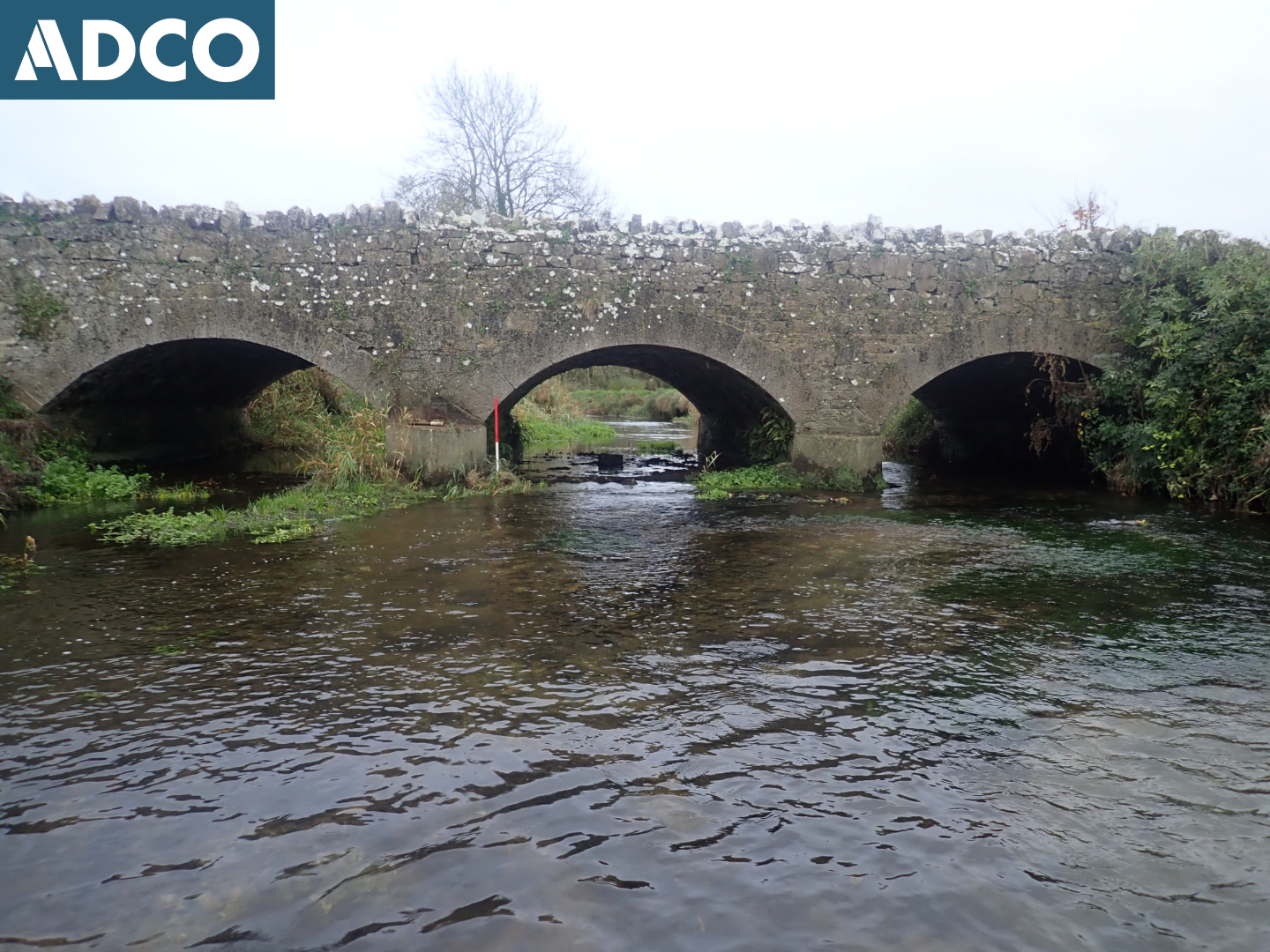
Curraclone (Inch) Bridge comprises a nineteenth-century, three-arched, masonry structure that carries the L-7950 and spans the Stradbally River (a tributary of the River Barrow) at ITM 660206E, 698264N. The bridge is not listed in the National Inventory of Architectural Heritage (NIAH). However, it is listed in an Industrial Heritage Review of Co. Laois (Ref: LAIAR 014-019).
Stradbally River passes close, c. 50m at its nearest point, to an ecclesiastical enclosure (RMP LA014-035003-) located at ITM 660277E, 698351N. Curraclone (Inch) Bridge is located 100m to the southwest of the RMP site. The waterway forms the boundary between the townlands of Monaferrick (to the south), Inch (to the northwest) and Curraclone (to the northeast).
Examination of the OS historic mapping suggests minimal changes to the river as it flows through Monaferrick and Inch Tds., the watercourse comprising both natural and artificially straightened sections of waterway (acting as field drainage) that follow established field boundaries.
A pre-disturbance underwater archaeological impact assessment (UAIA) was undertaken by ADCO in 2021 (21D0085, 21R0283) as part of the pre-planning requirement for the project.
The remedial works were completed between 22 and 29 September 2022, with much of the work being completed over a four day period between 26 and 29 September, water-levels precluding an earlier start to the in-water work. Archaeological monitoring of the following activities was conducted:
- Site step-up, 22-23 September.
- Excavation of the riverbed (western arch of the bridge), 26 September.
No features of archaeological or historical significance were observed in-river as part of the monitoring process. However, all deposits excavated from the riverbed were retained onsite, the up-cast material being spread across the adjacent bankside area, and metal-detection of this material recovered nine items of archaeological interest (22E0561:4-12). These items ranged in date from the fourteenth to the twentieth century, with the majority dating from the eighteenth and nineteenth centuries. One find was of particular interest, comprising an ecclesiastical seal matrix, of copper-alloy fabric, most likely dating to the fourteenth century (Find 22E0561:04). The matrix forms a pointed oval shape (vessica form) with a rib/pierced lug on its reverse side, running along its longitudinal axis. Its form, coupled with the presence of an integral fastening, suggests it was worn by a member of the clergy or other high-ranking church official.
The archaeological monitoring, coupled with the findings of the pre-disturbance UAIA, observes a high archaeological potential for riverbed surrounding Curraclone (Inch Bridge).
Excavation and Detection Device Licences were in place for the duration of the archaeological monitoring; DHLGH Licence numbers 22E0561 and 22R0268.