2022:928 - NEWTOWN JERPOINT, Kilkenny
County: Kilkenny
Site name: NEWTOWN JERPOINT
Sites and Monuments Record No.: KK028-062
Licence number: 22R0318
Author: Daniel O'Mahony, UCD
Author/Organisation Address: Belfield, Dublin 4
Site type: Settlement deserted - medieval
Period/Dating: Multi-period
ITM: E 656526m, N 640662m
Latitude, Longitude (decimal degrees): 52.514401, -7.167207
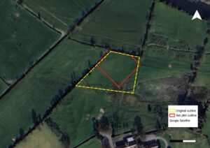
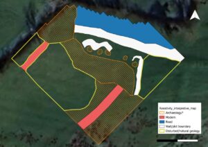
On 8 October 2022, an electrical resistivity survey was undertaken over 0.3ha of pasture west of the deserted medieval settlement core at Newtown Jerpoint, Co. Kilkenny. The work aimed to detect structural remains between excavated medieval buildings to the west and the eastern burgage plots. The survey revealed a broad low-resistance linear anomaly about 3m wide along the northern edge, corresponding with the line of a medieval road. Several high-resistance linear anomalies, up to 30m long, likely represent stone-built boundaries or wall footings. A curving anomaly approximately 25m in length encloses a cluster of low-resistance circular features 2–2.6m in diameter, interpreted as post-holes or pits. Within this enclosure, high-resistance patches measuring c. 8m and 12m across may represent a buried stone structure or yard surface. Diffuse resistance patterns to the west may indicate disturbed deposits or natural variation. The results point to a coherent arrangement of medieval structural and boundary features.