2022:927 - NEWTOWN JERPOINT, Kilkenny
County: Kilkenny
Site name: NEWTOWN JERPOINT
Sites and Monuments Record No.: KK028-062
Licence number: 22R0233
Author: Daniel O'Mahony, UCD
Author/Organisation Address: Belfield, Dublin 4
Site type: Settlement deserted - medieval
Period/Dating: Multi-period
ITM: E 656868m, N 640497m
Latitude, Longitude (decimal degrees): 52.512883, -7.162197
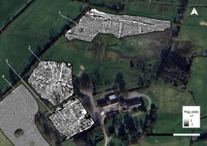
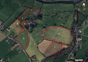
Between 1 and 10 October 2022, a magnetometry survey was undertaken over c. 13ha in seven plots forming part of the deserted medieval settlement at Newtown Jerpoint, Co. Kilkenny. The work aimed to identify sub-surface features relating to the settlement’s origins, development, and extent. The most significant results were in Plots 1, 2 and 6, where well-defined linear anomalies and discrete magnetic responses indicate medieval plot boundaries, routeways, and possible domestic or semi-industrial features, including circular anomalies 10–12m in diameter interpreted as hearths or burnt structures. Plot 6 also preserved the continuation of a sunken route or hollow-way, with associated subdivision boundaries and activity areas. In Plot 2, a concentration of anomalies clustered around a known building footprint suggests intensive occupation or dumping activity. Fainter linear features in Plot 7 correspond with a mapped boundary marking the settlement’s eastern edge. Other areas, including Plots 3–5, showed limited archaeological potential, with anomalies attributed to modern cultivation or garden use. Overall, the results indicate coherent medieval land-use organisation extending beyond the visible core, with several areas of high archaeological potential.