2022:660 - BALLYLINE, Kilkenny
County: Kilkenny
Site name: BALLYLINE
Sites and Monuments Record No.: N/A
Licence number: Unlicenced Monitoring
Author: Robert Hanbidge & Seán Shanahan; Shanarc Archaeology Ltd.
Author/Organisation Address: Unit 39a, Hebron Business Park, Hebron Road, Kilkenny
Site type: Burnt spread
Period/Dating: Undetermined
ITM: E 638102m, N 647635m
Latitude, Longitude (decimal degrees): 52.578671, -7.437828
Unlicensed archaeological monitoring of groundworks associated with a new forestry road development in the townland of Ballyline, Co. Kilkenny was carried out from 25th to 28th July 2022 in compliance with the archaeological conditions issued by the Department of Agriculture, Food and the Marine in granting Forestry Road Licence CN 89339.
The archaeological conditions noted that the route proposed for the Forest Road development was contiguous to, and passing over the northern section of a recorded archaeological site – Decoy Pond KK022-016—-, a landscape feature dating from possibly the 17th or 18th century.
Monitoring of groundworks focused on the construction of the main west-south-west to east-north-east road alignment, which was constructed partly to the immediate south side of an existing lane (that shown on historic OSi maps), and partly to the south side of a ditch and hedgerow field boundary. The groundworks traversed relatively level pasture, across two fields, to the northern extent of the decoy pond. The forest road was stripped to a width of 5m (north-south) for an approximate distance of 380m (east-west).
A spread of loose, small rounded stones, c. 2.5m wide, and extending approximately 158m east-west, was identified abutting the ditch and hedgerow field boundary to the eastern half of the forest road alignment. The deposit extended from a field gap at the settlement to the north of the forest road, running eastwards along the hedgerow boundary, and relates to a farm track which is visible on the 1995 OSi aerial imagery.
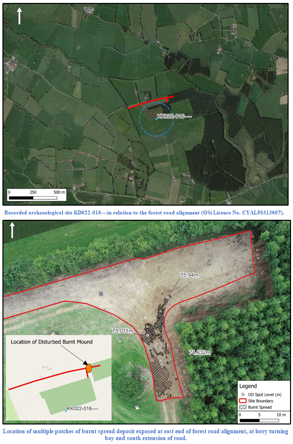
On the final day of monitoring, 28 July, an area measuring 18m (north-south) by 26m was stripped to provide a lorry-turning area. Several trees were harvested to facilitate these works. The access road turned south at this point for a length of 30m, between the tree line and the location of a sunken rectangular concrete water trough. The trough appeared to enclose a natural spring feature that was located in a hollow, with an area of slightly higher ground rising to the west of the trough location. During topsoil stripping of this area, evidence of patchy burnt spread deposits (centred on ITM 638102.215, 647635.749; OD 74.632m) that may represent the disturbed remains of a possible burnt mound, were uncovered. Dark charcoal-rich deposits were mixed with heat-fractured stone, appearing in multiple patches across the lorry-turning area, with further patches, albeit less prominent, towards the south end, next to the sunken water trough. The deposits did not appear to be very deep where they were exposed, and may extend westward beneath the location of the sunken water trough. No finds were found in association with the disturbed deposits.
The extent of the possible burnt mound was recorded via a RTK-enabled GPS, and no investigation works were carried out as the archaeological deposits could be preserved in situ. Taken together, deposits associated with the possible burnt mound covered an area that measured c. 27m long (north-south) by c. 11m. Sheets of terram were placed over the deposits. A crushed layer of shale stone sealed the terram area and was subsequently covered by a layer of 804 graded stone across the access road area. The insertion of the sunken concrete water trough, and a ditch or combined ditch and hedgerow shown extending south-west of the trough location on the 1995 OSi aerial imagery, likely account for disturbance in this area.

