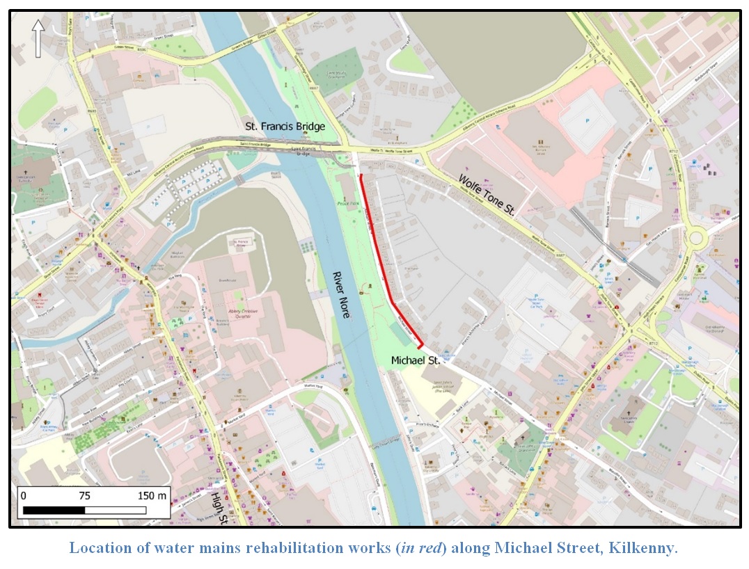
2022:656 - KILKENNY: Michael Street, Kilkenny
County: Kilkenny
Site name: KILKENNY: Michael Street
Sites and Monuments Record No.: KK019-026
Licence number: Unlicenced Monitoring
Author: Robert Hanbidge; Shanarc Archaeology Ltd.
Author/Organisation Address: Unit 39a, Hebron Business Park, Hebron Road, Kilkenny
Site type: Historic town
Period/Dating: Modern (AD 1750-AD 2000)
ITM: E 650672m, N 656307m
Latitude, Longitude (decimal degrees): 52.655583, -7.251052
Unlicensed archaeological monitoring was carried out between 4 and 24 May 2022 on behalf of Irish Water at Michael Street, Kilkenny. Groundworks followed the existing road corridor of Michael Street, which is situated within the Zone of Notification for the Historic City of Kilkenny (KK019-026—) but outside the medieval town defences associated with the medieval suburb of St John’s.
Archaeologically monitored groundworks comprised the excavation of a continuous slit trench along the north-eastern side of Michael Street as part of water mains rehabilitation. A single narrow silt trench (average 0.4m wide and 1.1m deep) was excavated; the trench commenced at the northern end of Michael Street, c.3m to the south of the junction with Wolfe Tone Street and directly outside House No. 54. The trench continued south-eastwards for an approximate distance of 233m.
The excavated trench was generally aligned in the road carriageway c.1.7m from the eastern/north-east edge of the road. The trench crossed to the western side of the street opposite the boundary between House Nos 21 and 22, where it terminated with a straight connection into an existing watermains below the western footpath. Several small trenches were excavated at a perpendicular angle along the eastern side of the trench to provide new water connections to adjacent houses.
At the start of the project on May 4, several trial holes were excavated at the north end of Michael Street to establish the location of existing services: electric, water & gas.
Overall, a similar stratigraphy was observed along the entire length of the slit trench, which comprised a top layer of tarmacadam (road surface) 0.1m thick that overlay a 0.1-0.12m thick layer of modern 804 grade hardcore. For the most part, these foundation deposits associated with the modern road directly overlay the natural gravel bank of the River Nore. This natural consisted of a mid-grey-brown coarse sandy gravel deposit that contained moderate amounts of rounded pebbles and small stones.
The earlier cast-iron watermain of the 19th/20th century that was being replaced was found running along the western edge of the slit trench. The natural gravels were reused as a redeposit to backfill this earlier mains trench, and thus a trench cut was impossible to decipher. A number of older mains connection services were noted in the trench, which connected the residential houses to the east with the old water mains. These connecting services were generally located in the upper levels of the gravel natural and within the 804 hardcore deposits.
Occasional lengths of historic stone cobbling were present outside house Nos 49-45 and 27-22. The 804 hardcore foundations deposits of the modern road surface directly overlay the cobbles, except for a layer of bitumen (0.1m thick) which was present over the cobbles outside house Nos 27-22. The cobbles measured an average 0.08m thick and consisted of small- to medium-sized rounded cobbles.
No other features, structures, deposits or artefacts that were of archaeological significance were uncovered during monitored groundworks.

