2022:652 - TROYSWOOD, Kilkenny
County: Kilkenny
Site name: TROYSWOOD
Sites and Monuments Record No.: N/A
Licence number: 22E0013
Author: Marion Sutton & Seán Shanahan; Shanarc Archaeology Ltd.
Author/Organisation Address: Unit 39a, Hebron Business Park, Hebron Road, Kilkenny
Site type: Habitation site and Industrial site
Period/Dating: Late Medieval (AD 1100-AD 1599)
ITM: E 649035m, N 660091m
Latitude, Longitude (decimal degrees): 52.689741, -7.274682
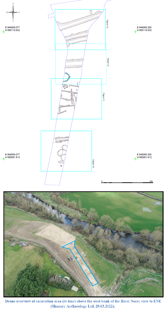
Archaeological excavation was carried out by Shanarc Archaeology Ltd. in Troyswood townland, Co. Kilkenny following the identification of archaeological features during archaeological monitoring of topsoil stripping at an extension of the Troyswood Water Treatment Plant, which is sited on the Freshford road (R693) above the west bank of the River Nore approximately 1.6km to the north-west of the modern urban limit of Kilkenny City.
Monitoring and subsequent excavation were carried out under licence 22E0013. Excavations were conducted between 2nd March and 8th April 2022. Works formed part of the Kilkenny City Regional Water Supply Scheme Upgrade, in Troyswood & Loughmerans townlands, Co. Kilkenny (see separate entry 2022:219 for excavations in Loughmerans under same licence number).
The site was excavated as a single area measuring 72m long N-S, with the E-W limit of the excavation defined by the construction cutting, which ranged from 5.7m wide at the south end to 19.5m wide at the north end. A total of 110 contexts were recorded throughout, of which 5 were recorded as deposits, the remainder being the cuts of pits, gullies or trenches, ditches, post-holes, kilns and a furrow, along with associated fills. A number of the features across the excavation area were cut directly into the natural substratum, lacking any stratigraphic relationship with other features. The majority were also only partially excavated, the construction cutting being a linear strip through an area of archaeological activity, with extensions of features surviving to both sides of the cutting. Context number C.54 was assigned to unstratified objects recovered across the site throughout the excavation, including objects retrieved during an associated the metal detection survey under licence 22R0227.
The site appears to consist of the broadly contemporary remains of medieval agricultural and industrial archaeological activity, and on the basis of the artefactual evidence the activity is likely to be high or late medieval in date (12th–16th century).
Many of the features were linear in nature, and oriented E–W or ENE–WSW, toward the west bank of the River Nore. Being on gently sloping ground, downhill to the river, many may have served a drainage function. The larger linears, interpreted as ditches, may have served as boundary features, or functioned as combined boundary and drainage features. Notably, ditch cut C.13, to the very north of the excavation area, appears to mark the southern limit of agricultural furrows, and may represent a former field boundary. Its proximity to ditch cuts C.98 and C.101, C.101 being a potential recut of C.98, might suggest repeat boundary formation in this area. The smaller linears, interpreted as gullies or trenches, were only encountered in the central excavation area, and appear to pre-date industrial activity in this part of the site, represented by kiln C.07 and possibly pit C.09, and an array of post-holes. Neither the gullies/trenches or post-holes provide definite habitation evidence, but there is a focussed use of this part of the site over time.
The fills within limekiln C.11 suggest it was open for a period of time after it ceased operating, or at least infilled over time, although the artefactual evidence in its fills appear to be broadly contemporary. Its production of quicklime may have been as a source of mortar for nearby buildings, and/or as agricultural fertiliser, although its siting on the bank of the River Nore is relatively fertile and productive land that may not have necessitated much fertilising by lime. The presence of cereals at the site suggests the second kiln, C.07, may have functioned as a kiln to dry cereals, and as the kiln was only partially excavated it has not been possible to assign it to a typological group. The kiln was earth-cut, lacking a stone lining containing charcoal rich fills.
Only one pit feature, C.09, contained evidence of possible in-situ burning, possibly suggesting a specific function, with other pits containing silty clay or silty sand fills with varying amounts of stone and charcoal, along with sherds of medieval pottery and iron objects.
A total of 286 objects were recovered during the excavation; the majority of these being sherds of medieval pottery, followed by metal objects, primarily the remains of iron nails and including two small pieces of possible waste iron.
A total of 66 samples were recovered during the excavation. Recovered samples include bone remains, primarily animal remains but also including one human remains sample, and palaeoenvironmental evidence comprising bulk soil samples, shell samples and lime samples taken from limekiln C.11.

