2022:790 - ATHENRY: Clarke Street/Cross Street, Galway
County: Galway
Site name: ATHENRY: Clarke Street/Cross Street
Sites and Monuments Record No.: N/A
Licence number: 21E0105 Ext.
Author: András Hindli
Author/Organisation Address: Burnside, St Oran's Rd, Buncrana, County Donegal
Site type: Historic town
Period/Dating: Late Medieval (AD 1100-AD 1599)
ITM: E 550119m, N 727650m
Latitude, Longitude (decimal degrees): 53.296797, -8.748252
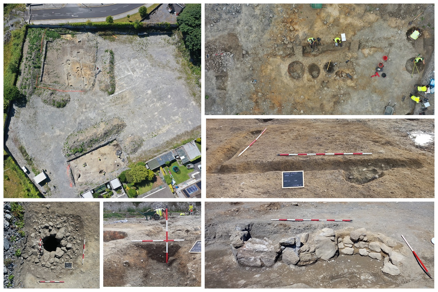
Two cuttings were opened and excavated within the site of a former creamery/co-operative complex in the south-western part of Athenry town centre, with the entrance proximate to the junction of Cross Street and Clarke Street. A number of archaeological features, some associated with metal production of domestic bronze/copper alloy vessels, were excavated and radiocarbon dated to the mid-13th century in Cutting A, whilst Cutting B presented slightly later (second half of 14th century) domestic activity in the form of waste pits associated with evidence of a former possible structure. Overall, the excavated sites represent a series of archaeological events, some of which were contemporary with the completion of Athenry’s castle, the grant of market charters, establishment of the Dominican Friary, and the later 14th-century murage. Evidence of later activity was also present in the following centuries, concluding with a complete and deliberate repurpose of the site in the late post-medieval period, being altered and incorporated into the gardens of Athenry House demesne. During the late 20th century, the site was levelled with the introduction of filling material, followed by the construction of a concrete surface and modern buildings, sealing the extant archaeology beneath.
Cutting A
The cutting measured slightly over 600m² and revealed the presence of at least three overlapping phases/horizons of activity, including late medieval, early post-medieval and late post-medieval demesne garden-related features. The earliest features identified within this cutting were associated with late medieval metalworks and the production of large bronze domestic vessels (radiocarbon dated AD 1219 – 1274 (median AD 1244). Several casting pits in a relative alignment (northeast – southwest) produced a considerable amount of casting moulds along with copper-alloy fragments. Additionally, several other pit-like features interpreted as waste pits producing a considerable amount of animal bone and seashells samples with butchering marks were also radiocarbon dated to within the same period, AD 1222-1274 (median AD 1246). The evidence for the production of copper-alloy/bronze vessels fits neatly with the apparent thriving economy of the medieval town of Athenry and the subsequent grant of market charter in 1241, which would enable the ideal background for local production and artisanry.
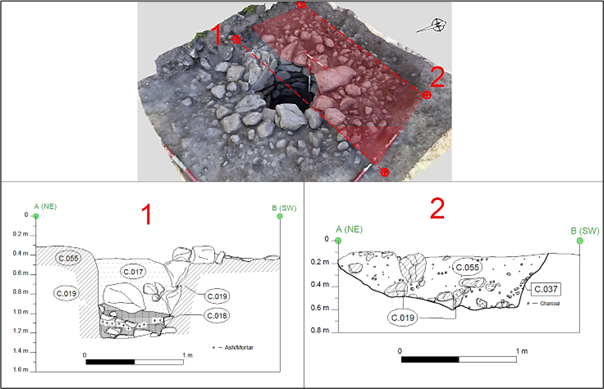
A stone-lined dumbbell-shaped cereal-drying kiln was also excavated and dated within the same historical period, AD 1272 – 1385 (median AD 1291). The kiln, although significantly truncated by a later feature, sustained a portion of the stone lining with a particular differentiation in materials used. The flue and a small portion of the firing bowl were lined with upstanding slabs of limestone, whilst the drying chamber was constructed of smaller sub-rounded sandstones, consolidated with clayed mortar. Archaeobotanical analysis carried out on samples from the kiln not only revealed the cereal species (mostly wheat and oats), but also concluded that there was a lack of remains evidencing cereal processing on site, thus suggesting the cereals were imported, probably cultivated and cleaned at some distance from the site.
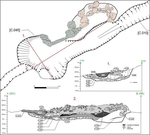
A relatively shallow rectangular ditched enclosure (extending beyond the cutting) truncated some of the aforementioned features (including the cereal-drying kiln) and was radiocarbon dated to a period spanning the mid-15th to mid-17th centuries. The remaining features were deemed to be late post-medieval and associated with Athenry House garden demesne.
Cutting B
The cutting measured approximately 320m² and the archaeological features also suggested different phases of activity. Radiocarbon analysis dated a total of three features to the late medieval period, in the second half of 14th century, slightly later than the results from Cutting A. Stratigraphic relationship and comparison by shape and composition with accurately dated features allows for speculation of an estimated 10 additional features that could have been dated in the late medieval period. These features were represented mostly by pits and evidence of a possible former small rectangular structure. A well and a number of larger features (exclusively waste pits) were interpreted as a later phase of activity within Cutting B. Given the lack of any dating evidence, these features could range between the end of 14th century (late medieval) to late post-medieval period.

A very rudimentary and narrow well was partially excavated within this cutting, and subsequently preserved in situ during later stages of archaeological works. Unfortunately, it was not possible to securely determine a date for this feature. A sherd of late medieval Saintonge mottled green glazed pottery – doubtlessly an intrusive find from residual activity on the site – was recovered during the monitoring stage from the lowest excavated fill of the well’s shaft. The corbelling for the well consisted of large stones and boulders pinned by smaller stones, constructed with the dry stone technique and in a random course with a circular pattern. The construction phase suggests that it was built inwards with corbelling until the well shaft was established. The lack of evidence of former sealant, in the form of render, as well as the size and rudimentary construction suggested that this well might have been associated with the gardens of Athenry House, and it may have been simply for irrigation or as a garden feature.