2022:931 - DUBLIN 24: SSHR Building, TU Dublin Tallaght Campus, Tallaght, Dublin
County: Dublin
Site name: DUBLIN 24: SSHR Building, TU Dublin Tallaght Campus, Tallaght
Sites and Monuments Record No.: N/A
Licence number: 20E0512
Author: Kate Taylor, TVAS (Ireland) Ltd
Author/Organisation Address: Ahish, Ballinruan, Crusheen, Co. Clare
Site type: Pit and Enclosure
Period/Dating: Multi-period
ITM: E 709270m, N 727970m
Latitude, Longitude (decimal degrees): 53.290759, -6.361050
Archaeological monitoring at the Sport Science, Health and Recreation (SSHR) building, TU Dublin Tallaght Campus, was undertaken during initial construction groundworks between 9 and 18 September 2020, although works in a final small area were not completed until 20 January 2022.
The development site occupies parts of two fields that were covered with rough long grass prior to works commencing. The development largely overlapped with a previous phase of work which had been archaeologically examined in 2010-2011 (10E0026 McQuade; 11E0054 Ruttle) and the 2020 monitoring was concentrated on areas of the development site that had not previously been archaeologically investigated.
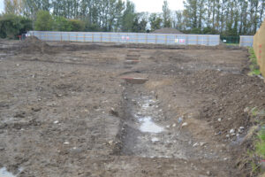
Several features of archaeological potential were identified and these were subsequently excavated under the same licence. The excavation primarily revealed linear features such as ditches and drains, with a few pits and a possible causeway also identified. These features were dated, through find typology, stratigraphic relationships and radiocarbon determinations, to the Chalcolithic/Early Bronze Age, late medieval and early modern periods.
The earliest feature was a single pit radiocarbon dated to 2342-2140 BC (UBA-49643; 3802BP±29), placing this feature between the end of the Chalcolithic and beginning of the Early Bronze Age. The small oval pit contained no artefactual material, but did yield some archaeobotanical remains including charred cereal grains (unidentifiable), charred hazelnut shell and possible cherry or plum stone.
Three parallel and perpendicular medieval ditches formed part of a large field system, part of which was recorded in the previous phase of work. Two of these ditches were typically no more than 0.5m deep, but the northernmost ditch was more substantial, deepening to the east to a maximum of 1.6m and was up to 4.7m wide. This ditch presumably represents a more significant property boundary. Finds from the ditches included pottery (Leinster Cooking Ware and Dublin-type wares), along with animal bone and occasional iron nails. A cattle molar from the upper fill of the larger ditch returned a calibrated radiocarbon date range of AD 1217-1271 (UBA-49644; 809BP±21) which is consistent in date with much of the pottery also identified from this context, most of which is 13th century in date.
Later activity was also recorded. A stone causeway had been laid over the infilled large medieval ditch, presumably to aid passage across the soft and wet ditch fill. Later still were ditches, drains and furrows that align with the field layout visible on 19th-century mapping.
The excavation did not reveal any early medieval material and it is clear that the ecclesiastical enclosure surrounding St Maelruan’s Church to the south-west did not extend this far. Aside from the single prehistoric feature, the excavated evidence is consistent with a site lying on the outskirts of the medieval settlement of Tallaght.