2022:717 - Little Britain Street, Dublin North City, Dublin
County: Dublin
Site name: Little Britain Street, Dublin North City
Sites and Monuments Record No.: N/A
Licence number: 22E0697
Author: Paul Duffy
Author/Organisation Address: c/o IAC Archaeology, Unit G1 Network Enterprise Park, Kilcoole, Co. Wicklow
Site type: Medieval and post-medieval walls
Period/Dating: Multi-period
ITM: E 715126m, N 732555m
Latitude, Longitude (decimal degrees): 53.330706, -6.271595
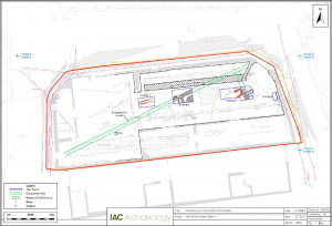
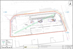
| Archaeological test trenching was carried out on site from 12 to 14 September 2022. This required extensive saw cutting and rock breaking and was carried out using a 13-tonne 360 degree tracked excavator, with a flat, toothless bucket, under strict archaeological supervision. It was initially proposed to excavate three parallel east-west trenches across the site following the demolition of the upstanding structures, however, due to limiting site conditions the full trench could not be excavated. Instead, four targeted cuttings were made along the line of the previously proposed central trench.
Testing revealed up to 2.7m of stratified archaeological deposits onsite. The testing confirmed that the eastern rubble-built limestone wall of the standing warehouse is of post-medieval date. Substantial walls of probable medieval date have also been identified along with structural remains of 18th- and 19th-century date. An 18th-century redbrick culvert capped with slabs of calp limestone was identified running diagonally across the site. A large wall was identified running north-east/south-west in the centre of the site and a second wall running north-north-west to south-south-east was encountered towards the east of the site. Both walls were constructed of calp limestone bonded with a cream-coloured lime mortar. A large redbrick lime kiln was identified built against the western side of the north-west/south-east running wall. The testing results have broadly confirmed the development sequence onsite as suggested by the historic mapping. The large wall running north-east/south-west across the centre of the site follows the line of the outer precinct wall of St Mary’s Abbey as shown in Speed’s 1610 depiction of Dublin. A C14 sample from a charred hulled barley grain from the fill of the construction cut for this wall yielded a two-sigma date range of AD 924–1026. While in isolation, this early date must be regarded with some caution, it was not contradicted by any artefactual evidence from the small exploratory sondage excavated to the bottom of the wall. Subsequent maps show that this property line was maintained into the 18th century and structures built up against it as shown in Rocque’s map of 1756. Sometime in the later 18th or early 19th century, the boundary wall was dismantled and the plot extended northwards to create the current site layout. As late as 1854 however, the line of the former precinct wall was maintained in lease mapping.
|


