2022:484 - DÚN LAOGHAIRE: Blackglen Road scheme, Dublin
County: Dublin
Site name: DÚN LAOGHAIRE: Blackglen Road scheme
Sites and Monuments Record No.: N/A
Licence number: 21E0638
Author: Eoin Halpin, AHC Ltd.
Author/Organisation Address: 36 Ballywillwill Road, Castlewellan Co Down BT31 9LF
Site type: Town
Period/Dating: Modern (AD 1750-AD 2000)
ITM: E 717393m, N 725270m
Latitude, Longitude (decimal degrees): 53.264769, -6.240270
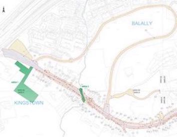
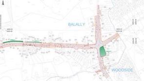
The Blackglen Road improvement scheme ran from the junction of Harold’s Grange Road with Grange Road in the west to the junction of Blackglen Road with the R117 to the east. A short section of Sandyford Road, Enniskerry Road, Hillcrest Road, Grange Road and Slate Cabin Lane/Woodside Road junction was also included. The scheme traversed the townlands of Taylors Grange, Ballaly, Woodside, Kingstown and Barnacullia.
Five areas of potential archaeological interest were monitored between September 2021 and October 2022. There were no surviving features or deposits in Area 1, the compound and compound extension. The main compound lay substantially within ground previously disturbed in the course of the construction of the M50. The area of the compound extension merely had the topsoil partially removed and a stone surface laid down.
The main feature of Area 2 was the stone culvert. A close examination of the cartographic evidence is informative. Although not particularly detailed, the 1st edition OS map of c. 1834 would appear to show the stream running up to the southern edge of the road and emerging again on the north side. However, the 4th edition map of some 80 years later records the stream disappearing some distance short of the south side of the road, which was confirmed in the archaeological monitoring, where the southern opening of the culvert was located some 15m south of the road. It is tempting to see this extension of the culvert on the south side as being built to allow access across the stream and into the site of the eastern of the two cottages built nearby. These cottages, there is a second pair built immediately to the west, comprise a small single terrace of two one-and-a-half storey, three-bay rough rendered houses with twin dormer windows to the roof and a rear garden with its own access. The houses do not appear on the 1834 map, but are shown on the OS map of c. 1909. If there is, as seems likely, a relationship between the construction of the culvert and the provision of access to the site of the cottages, this would put a construction date for the culvert at the same time as the cottages, in the latter half of the 19th or early 20th century.
The L-shaped building in Area 3 was not recorded on the map of 1834 but was on the map of 1930. The late date for its construction was evidenced by the recovery of relatively modern glass, ceramics and red brick from on and around the likely house floor surface. The possible standing stone feature was re-interpreted as a gate pillar associated with the entrance to this probable house site.
Nothing of archaeological interest was noted in the relatively undisturbed area of road take in Area 4, and the Mail House in Area 5 was surveyed and described prior to it’s demolition as part of the works to the road junction.


