2022:797 - SHANNONPARK, Cork
County: Cork
Site name: SHANNONPARK
Sites and Monuments Record No.: N/A
Licence number: 21E0217
Author: Colm Chambers
Author/Organisation Address: John Cronin & Associates, Westpoint Trade Centre, Ballincollig, County Cork
Site type: Hilltop enclosure, Ringfort - rath and Cremation pit
Period/Dating: Multi-period
ITM: E 573163m, N 563877m
Latitude, Longitude (decimal degrees): 51.826488, -8.389333
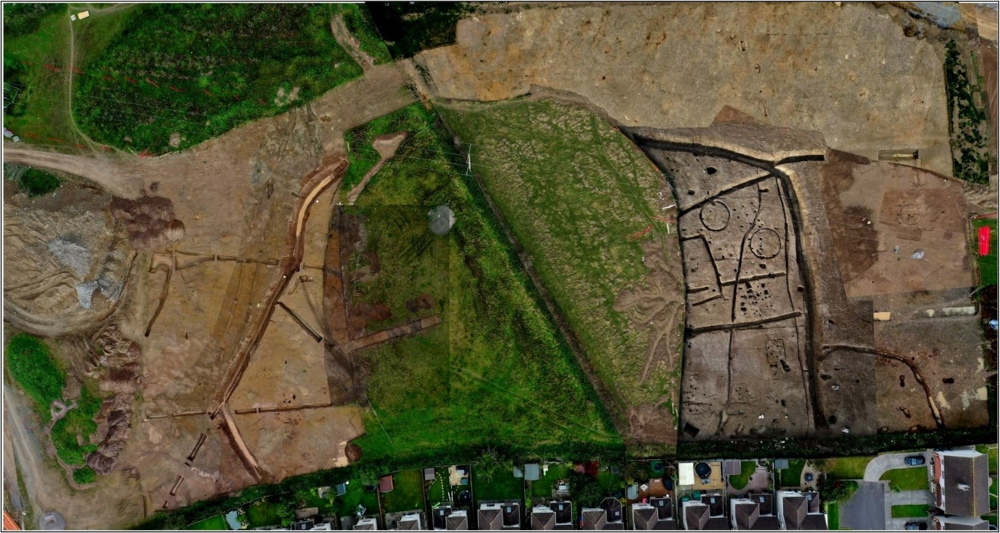
The archaeological excavation works detailed below followed the discovery of several features of archaeological potential within a proposed development site during a programme of geophysical survey (20R0158) and a subsequent programme of archaeological testing (20E0573). The features uncovered during testing included a number of pits, post-holes, a number of possible cremation burials, two possible cereal-drying kilns, a possible souterrain, a portion of the ringfort ditch (first identified during geophysical survey), and a portion of an earlier ditch which was truncated by the ditch of the ringfort. The excavation site was divided into 4 areas which were further divided into 14 sub-areas. Archaeological activity was noted within all areas of the site, with finds and features dating from the prehistoric through to the modern era noted.
Fragments of several pottery vessels and a number of pieces of lithic material were recovered from a number of pits along the northern portion of the excavation area. Where it was possible to establish a date for the vessels, they were invariably early Bronze Age in date. A pit-like feature containing early Bronze Age pottery and a large upright stone slab, which may have represented the basal remains of a broken standing stone, was also identified during excavations. A series of probable cremation burials containing token deposits of burnt bone were recovered from six earth-cut pits. In general, the volume of burnt bone recovered was quite low. An inverted saddle quern was capping one of the cremations. The minimum number of individuals represented was five adults and one juvenile. There was no evidence of duplication of skeletal elements in any of the six burial contexts. A radiocarbon date of BC 1415-1261 from one of the cremations suggests that the revealed features were indicative of middle Bronze Age funerary activity.
A ditch representing the remains of a hilltop enclosure was noted within Areas 2, 3 and 4. This ditch followed the natural contours along a portion of its length at the west and northwest, and formerly enclosed an area measuring c. 140m in diameter (east to west) and was over 1ha in area. The ditch was generally U-shaped and measured up to 4m wide and was cut up to 2m below the level of the top of the natural subsoil. The enclosure ditch appeared to have originally encircled the hilltop, although the southern portion was lost to development in the early 2000s. No entrance feature was noted during excavation, and this may have been removed during the construction of a residential development to the south or may survive within a c. 60m long section of the ditch which has been preserved in situ within the northern portion of the archaeological buffer. The basal fill of the ditch produced a radiocarbon date of AD 255-417, demonstrating that the enclosure was constructed and in use prior to the end of the Iron Age. An upper fill of the ditch dated to the end of the early medieval period (c. 1101AD). This suggests that the ditch was cut during the Iron Age and began to be backfilled around the start of the early medieval. The ditch appeared to define the majority of the early medieval activity on site, indicating that it continued in use during this period and was nearly completely backfilled by the end of the early medieval period.
The multivallate ringfort set within the hilltop enclosure, which was identified during predevelopment geophysical survey and preserved within the archaeological buffer, was tested during the programme of excavation, and found to be formed of three banks and two ditches, including a levelled outer bank, an outer ditch, a levelled middle bank, an inner ditch and a levelled inner bank. A charcoal sample from the basal fill of the inner ringfort ditch returned a radiocarbon date of Cal AD 541-638 indicating that the ringfort was likely constructed in the early part of the early medieval period. The outer ringfort ditch was found to have been constructed sometime after AD 666-819. The addition of an outer ditch may be suggestive of an increase in the status of the site or the occupants of the site.
The remains of a total of nine possible structures (Structures A-I) were identified during excavation works. Two probable structures were noted within Area 3, a roundhouse (Structure A) and a likely post-built structure (Structure B), while the remaining structures (Structures C-I) were within Area 4. Radiocarbon dates from samples for three of the structures returned early medieval dates, while an occupation deposit associated with another of the structures also returned an early medieval date.
Evidence for cereal processing was identified in the form of several cereal-drying kilns identified across excavation Area 4. A number of these were dated to the early medieval period and analysis of the charred cereal remains suggests that brewing may have been carried out on-site during this period. A possible grain silo (Structure G), represented by a regular arrangement of nine large post-holes set in three rows of three, was also identified during works and a portion of a rotary quern was also recovered during excavation works.
The metalworking remains from Shannonpark dated to the end of the Iron Age and the early part of the early medieval period, a period for which few large forging assemblages are known to date. The site is a rare example where seemingly only bloom processing took place.