2022:189 - CAHERCONNEL, Clare
County: Clare
Site name: CAHERCONNEL
Sites and Monuments Record No.: N/A
Licence number: 22E0226
Author: Noel McCarthy
Author/Organisation Address: School of Geography, Archaeology and Irish Studies, University of Galway
Site type: Platform
Period/Dating: Undetermined
ITM: E 523628m, N 699503m
Latitude, Longitude (decimal degrees): 53.040730, -9.138848
The excavation targeted two features adjacent to Caherconnell Cashel.
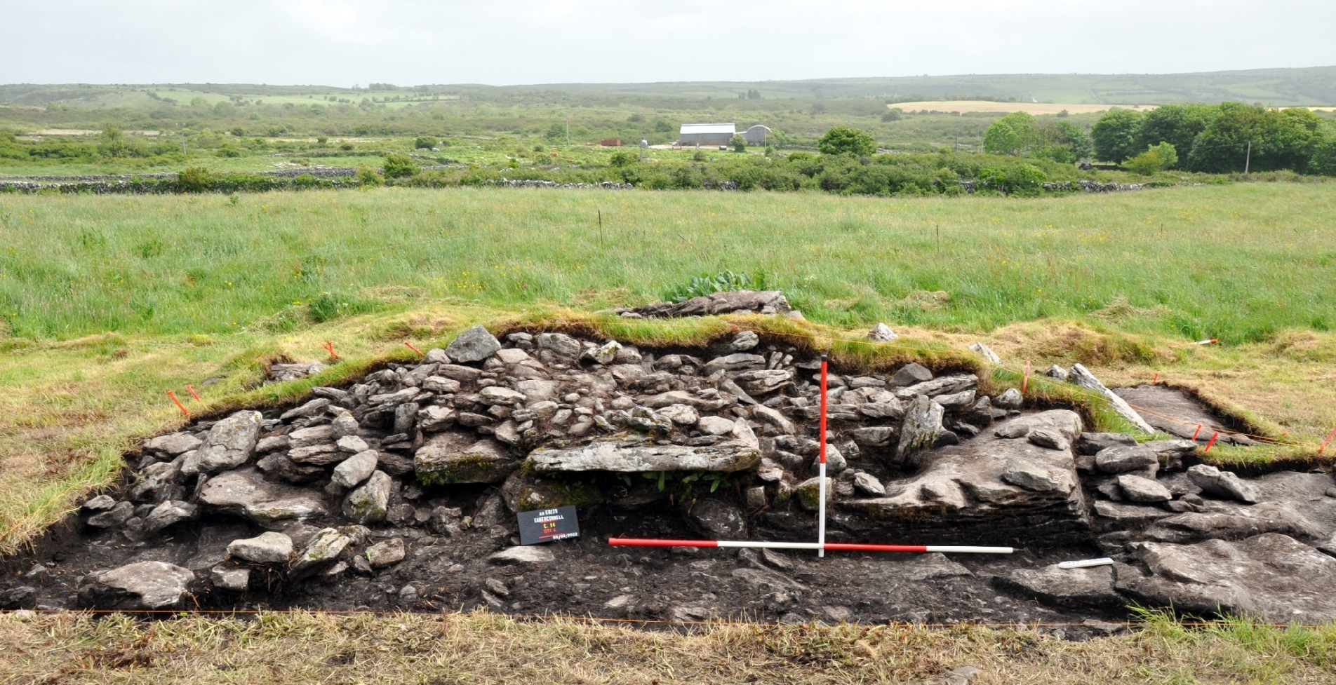
Site A was a dry-stone built platform constructed close to the cashel entrance. Prior to excavation the site appeared as a sub-circular mound of limestone slabs and soil, which could have originated from a variety of time periods.
Excavation revealed a very considered internal structure of large limestone slabs, creating a platform that may once have stood 0.8m above the surrounding ground level. The platform had a rectangular outer footprint (3.1m north-south x 4m) with two layers of quite large flat slabs at its centre. Each was sub-oval in plan with the lower layer of slabs creating a level surface in concert with the underlying bedrock. The upper layer of slabs was contained within an outer sub-oval ring of mid-sized slabs. These slab layers do not represent different phases of activity but are part of a single construction sequence.
Two large prostrate slabs on the western side of the platform would originally have stood upright, indicating a façade of upright stones on this side. The north and south sides of the platform were formed by low, straight walls/revetments that largely survived as a single course. The platform was constructed atop a distinct limestone bedrock plinth that enhanced its profile, making it a notable feature just outside the entrance to Caherconnell. No evidence of a wooden component was identified, though, as is the case across the Burren, such elements leave little evidence if built upon the karst limestone bedrock.
A small number of artefacts was recovered during the excavation of the platform, though none could be reliably attributed to the construction or use of the platform. A number of chert scrapers and knapping debris are consistent with activity at the Early Bronze Age structure located c.40m to the south, while fragments of a decorated bone comb and a medieval-style nail, draw clear parallels with material found within Caherconnell 20m to the west.
Though the purpose of the platform is uncertain, it was most likely associated with the nearby cashel and may have served a variety of functions, from a platform for declarations or audiences, to the base for a now-lost market cross.
Site B investigated a doline located c.40m south-east of Site A. The feature was notably devoid of archaeological evidence (only two pieces of chert debitage were recovered) given its close proximity to the cashel and Early Bronze Age house, while there was only one homogenous layer of soil above the natural subsoil and bedrock. A single pit/hollow was uncovered that contained a fill of loose, naturally occurring iron ore.
The lack of archaeological remains encountered during excavation of the doline stands strongly at odds with the general pattern in the vicinity of Caherconnell, where the longevity of activity in the vicinity has created a consistent scatter of artefacts and detritus in the locale. Within this distributional pattern it appears likely that the doline was cleared of its original deposits in the past, possibly to exploit a more extensive spread of iron ore, a small portion of which survived. Evidence of iron smelting was uncovered within the nearby cashel and it is unlikely that such a nearby source of ore would not be exploited by the smith working within.