2022:721 - Barrack Street/Potato Market/Kennedy Avenue, Carlow, Carlow
County: Carlow
Site name: Barrack Street/Potato Market/Kennedy Avenue, Carlow
Sites and Monuments Record No.: CW007-018
Licence number: E004653; C000731 (ext.)
Author: Robert Hanbidge & Seán Shanahan; Shanarc Archaeology Ltd.
Author/Organisation Address: Unit 39a, Hebron Business Park, Hebron Road, Kilkenny
Site type: Urban, post-medieval
Period/Dating: Modern (AD 1750-AD 2000)
ITM: E 672291m, N 676450m
Latitude, Longitude (decimal degrees): 52.834144, -6.927131
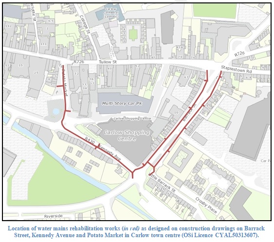
Licensed archaeological monitoring of ground works associated with the rehabilitation of 941m of existing water mains and all associated assets at locations in Potato Market, Kennedy Avenue (R430) and Barrack Street (R448) in Carlow Town was carried out between July and October 2022, under an extension of Ministerial Consent C000731 (Excavation Registration no. E004653 and Detection Device Registration no. R000408).
The development works were located in the south-eastern quadrant of the historic core of Carlow town, with works at the Potato Market and to the north-western half of Kennedy Avenue being located within the Zone of Notification for the historic town (CW007-018). The works to the south-eastern half of Kennedy Avenue and on Barrack Street were located outside the Zone of Notification.
Archaeologically monitored ground works generally consisted of the excavation of pits (both launch pits and trial pits) to facilitate horizontal directional drilling for the installation of the replacement water-mains, to investigate the suitability of the stratigraphy for directional drilling and to located pre-existing services. The launch pits/trial pits were generally narrow in form and varied in size owing to their specific location requirements; they approximately measured between c. 2.1-2.8m in length, c. 0.75-1.35m in width and 0.85-2.6m in depth. The pits were sited at multiple points along the replacement water-mains alignment to both sides of Barrack Street and to the south side of Kennedy Avenue. Open slit trenching was used along the scheme where directional drilling was not possible, and wholly at the north-west end of Kennedy Avenue and wholly at the Potato Market. Open slit trenching was also used where underground services and connections required open air works. The main water-mains slit-trench generally measured 0.9m in width and 1.2m in depth (1.9m being the maximum excavated depth). A range of services were encountered at various depths and orientations within the launch/trial pits and in the main slit-trench.
The general stratification comprised an upper tarmac road surface (0.06-0.2m thick) which was generally installed over either a rubble or hardcore bedding deposit (0.05-0.3m thick) which directly overlay the natural. The natural varied across the scheme but generally consisted of lighter brown to beige coloured sterile coarse gravels, sands and alluvium.
Monitoring of works along Barrack Street revealed some historic details. An area of cobbles representing a historic road surface was exposed in one launch pit on the east side of Barrack Street. Occasional pieces of animal bone from both sides of Barrack Street were recovered from what were otherwise sterile natural gravel deposits. The bone was interpreted as representing evidence of disturbance, either from redeposited natural or from the movement of material as a result of directional drilling through unexposed deposits. The only deposits exposed containing post-medieval artefactual materials were to the east side of Barrack Street, at the north and south ends, the material at the north end overlying a dark coloured organic soil 0.75m below the present ground level.
On Kennedy Avenue, building debris exposed below the modern road make-up to the north-west half of the street included occasional worked architectural stone. Also on Kennedy Avenue, the top flagstone/capstone of either a culvert or culverted millrace was revealed.
No evidence of the potential medieval town defences (CW007-018006) was identified during any of the monitored excavation works.

