2022:813 - CARRICKFERGUS: Bashfordlands Phase 3, Antrim
County: Antrim
Site name: CARRICKFERGUS: Bashfordlands Phase 3
Sites and Monuments Record No.: N/A
Licence number: AE/21/059
Author: Ciara MacManus/ Farrimon Macmanus Ltd
Author/Organisation Address: —
Site type: Excavation - miscellaneous
Period/Dating: Multi-period
ITM: E 742191m, N 889428m
Latitude, Longitude (decimal degrees): 54.732772, -5.792126
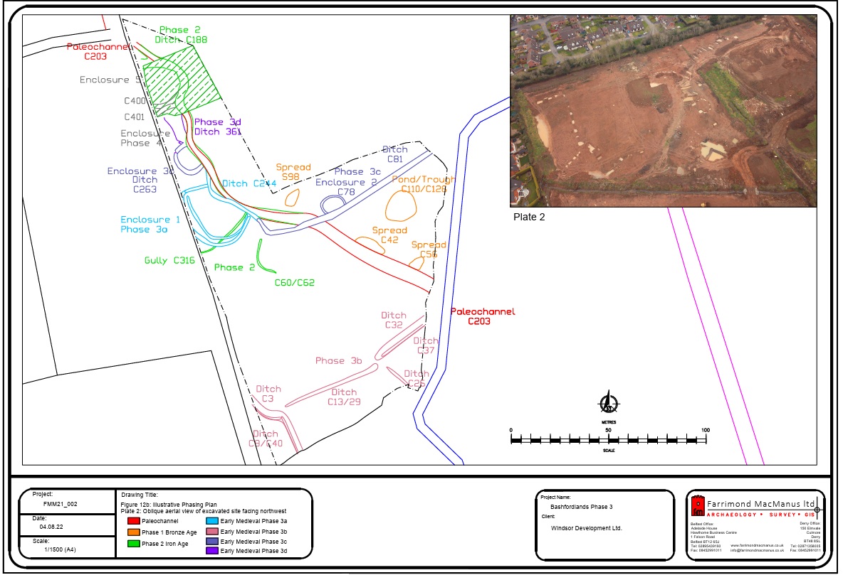
Archaeological monitoring was carried out at Phase 3 development works across a large green field site located at the southern end of the proposed development area where previous archaeological test trenching had been carried out in 2010. Archaeological activity spanning multiple time periods was identified across the Phase 3 area, consisting primarily of an extensive north to south orientated ditch flanked by several ditched enclosures, burnt spreads and enclosure gullies. Several features could be attributed to the Bronze Age period; however, the majority of the recorded features were early medieval in date with the larger enclosure ditches appearing to be of a similar construction to the enclosure identified in the Phase 2 works.
Archaeological remains identified at Phase 3 development at Bashfordlands, Co. Antrim represented the remains of human occupation at the site dating from the late Bronze Age through to the early medieval period, albeit not on a continuous basis. A primary catalyst for the concentration of occupation within this portion of the site over such a long period of time appears to be the location of a paleochannel which extended across the site from the northwest corner south eastwards across the site. It provided a focus for prehistoric cooking activities and was re-utilised during the Iron Age and early medieval periods. The same channel was partially identified within Phase 1 development works in 2017 with evidence for associated prehistoric burnt mound material. Indeed the full extent of the paleochannel can also been inferred from modern flood risk mapping indicating that that it has always been a natural drainage sink within the local landscape.
Analysis of the flint assemblage suggests that occupation within the surrounding landscape began in the Mesolithic period. A total of 232 pieces were recovered with 78 deemed to have been worked. The Mesolithic assemblage included a number of later Mesolithic butt-trimmed flakes recovered as surface finds and also from features C42, C188, C32. The recovery of the butt-trimmed flake from trough C42 suggests that this might represent the earliest phase of cooking activity associated with the utilisation of the paleochannel. The remainder of Mesolithic flint tools, along with a proportion of worked flints which were identified as being blade- and convex end-scrapers from the late Neolithic to Early Bronze Age, were recovered from the various later ditch features across the site and are more likely to be intrusive finds which had been washed into the various drainage ditches.
The main focus of prehistoric occupation appears to be in the form of burnt mound/spread deposits which are commonly associated with prehistoric cooking sites. While the recovery of a butt-trimmed flake from trough C42 suggests an early origin for this features, burnt spreads are traditionally indicative of cooking sites, the majority of excavated examples of which are dated to the Bronze Age.
The most significant burnt mound activity at the site was represented by the excavation of a substantial “pond” pit followed by a later cooking trough or pit. The “pond” pit certainly appeared to be anthropogenic in nature given the regularity of its sides and relatively flat base. Few comparative sites can be referenced in terms of establishing a function for this feature. The closest comparative site to date would perhaps be the man-made pool at Kings Stables, Co. Armagh.
The later trough which was excavated into the south-east quadrant of the now infilled “pond” was equally large in comparison to typical cooking trough sizes which average c.2m x 1m and c.0.5m deep, although this does vary from site to site. But it does suggest that it provided for a larger-scale operation than merely the cooking place of a seasonal hunting site as is a common site interpretation. It seems difficult to image the volume of heated stone which would have been required to boil a trough this size which could contain at least 8000 litres of water. The in-situ stakes along the north-west edge of the trough may have been used to support props for hanging food parcels or cooking utensils/pots over or into the trough, particularly given its depth. Around the lower levels of the trough the poorly preserved remains of wattle and five uprights were discovered. Given the size of the trough and its association with the early “pond” feature in terms of its location, it may be hypothesised that it functioned as a feasting location for further ritual or social gatherings.
The next phase of activity within the site is marked by the construction of a large ditch (C188) which appears to have largely followed the alignment of paleochannel C203, a radiocarbon date from the basal fill of the ditch returning an Iron Age date of 231-52BC (cal. 2 sigma).
Full interpretation of this early ditch feature was made complicated by the nature of preserving in situ the northern section of the ditch which coincides with the placement of Enclosures 4 & 5 which are assumed to be later in date. The function of this feature appears to have been largely for drainage purposes and may represent the initial phase of land management for agricultural purposes within the local landscape which was further developed upon during the early medieval period.
The majority of archaeological remains identified in the Phase 3 development area at Bashfordlands, Carrickfergus represent the remains of a series of phased early medieval enclosures dating from the late 4th to late 8th centuries AD.
A definitive sequencing of all of the enclosures was not achievable under the constraints of in situ preservation of the northern end of the site, but it does appear that the enclosures were constructed on a phased basis, the earliest phase starting from the very beginning of the early medieval period concentrated at the southern end of the site with later activity extending northwards.
The function of the enclosures at Bashfordlands is not immediately apparent as none of the enclosures contained clear evidence of internal activity. The recovery of souterrain ware from many of the ditch fills also suggests that some amount of domestic activity was occurring at the site, but whether this was ancillary to the main function of the enclosures is not clear. It is not unusual for the internal spaces within early medieval enclosure sites to lack evidence for domestic or other activity.
The recovery of two glass beads from the surface internal area of Enclosure 5 may indicate domestic activity within this enclosure, perhaps in tandem with metal working as evidenced by the recovery of fragments of slag from the surface, and therefore could represent a contemporary enclosed settlement.
The early medieval enclosure settlement discovered c. 200m to the west during Phase 2 was dated to towards the end of Phase 3b enclosure activity. It is possible that at least some of this enclosure and agricultural activity is associated with this settlement.
There was also evidence for small-scale metal production taking place associated with occupation at the site in the form of a small potential furnace pit located between Enclosures 3 & 4.
While it seems that the primary function of Ditch C188 appears to be drainage of the site downslope towards the lower south-east portion of the site following the line of a natural paleochannel, the other linear ditches are likely representative of contemporary field divisions within the local landscape.
Ditches C3 and C32 correspond well with the expected depth of boundary ditches although there was no evidence for an associated bank. Ditch C81 produced evidence for a stone wall or stone-lined bank along its southern edge which had collapsed into the ditch.
Environmental results from soil processing indicate that the field ditches within the southern portion of the site were potentially lined with blackberry bushes, with the recovery of buttercup seeds indicating that the function of the field was for livestock grazing as supposed to tillage. A similar picture is provided for the later phase boundary ditch at the northern boundary (C81) although the recovery of barley grains also suggests a degree of crop production within this portion of the site. Barley appears to be the predominant crop remains recovered from the main drainage ditch (C188) and the enclosure ditches, followed by small quantities of oat. This is consistent with larger-scale analysis of crop remains for the period where, during the earlier period of early medieval settlement, barley appears to be the main crop source followed by oat. The recovery of a saddle quern from within the ditch fill of C244 confirms that there must have been some secondary crop processing being carried out in and around the enclosures themselves.
It should be noted also that both Ditches C13 and C78 respect the alignment of the modern-day field boundaries, with the modern boundary ditch of the northern portion of the topsoil-stripped field located 16m to the north of ditch C78 and the southern boundary ditch of the modern field located 30m south of Ditch C13. This clearly demonstrates that the layout of some of the modern field boundary divisions have their origins in much earlier boundary demarcations.