2021:564 - COOLAGAD, Greystones, Wicklow
County: Wicklow
Site name: COOLAGAD, Greystones
Sites and Monuments Record No.: N/A
Licence number: 21E0083
Author: Muireann Ní Cheallacháin, c/o IAC Archaeology Ltd.
Author/Organisation Address: Unit G1 Network Enterprise Park, Kilcoole, Co. Wicklow
Site type: Excavation - miscellaneous
Period/Dating: Prehistoric (12700 BC-AD 400)
ITM: E 727697m, N 713014m
Latitude, Longitude (decimal degrees): 53.152305, -6.090804
A programme of archaeological testing was carried out over the course of nine days from 12 April 2021. 84 trenches were excavated targeting geophysical anomalies and open green space.
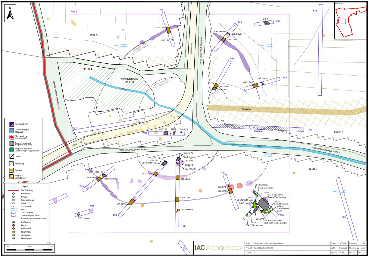
Testing revealed eight areas of archaeological potential, which have been designated as Archaeological Areas 1–8:
• AA 1: Testing at AA1 confirmed the presence of a partially disturbed, plectrum-shaped enclosure (possible original int. diameter: 95m x 90m). A smaller central, possibly oval enclosure (possible original int. diameter: 55m x 50m) was also identified. Testing also confirmed the presence of internal features including slot trenches, pits, post-holes and hearths. External features including hearths, gullies and a concentration of industrial activity probably associated with cereal-drying activity were also identified. No diagnostic artefacts were retrieved. It is tentatively suggested that, given the form, landscape and archaeological setting, that the bi-vallate enclosure is of early medieval date.
Trenches 37 and 46 have revealed that a broad east–west running swathe (c. 25m wide) of disturbance cuts through the central area of the enclosure. This truncation appears to have been caused by the installation of water pipes feeding from the stream at the east and the construction of the farm laneway at the west. The historic field boundaries that traverse the site will also have had an adverse impact on the enclosure ditch.
While the outer enclosure ditch ranges in width from 2.5m to 4m, and the inner enclosure ditch from 2.1 to 3.2m, the relatively shallow nature of the ditches (Outer: 0.84m-1m deep, Inner: 0.76m), as well as the shallowness of some of the internal and external features (average depth 0.18-0.3m), suggests the site has been truncated by agricultural activity.
• AA 2a–c: Probable prehistoric activity in the form of troughs and pits associated with burnt mound activity along with pits and in-situ burning of unknown date,
• AA 3a–e: A burnt spread of probable prehistoric date, a slot trench windbreak surrounding in-situ burning, a possible kiln and various linear features and pits of unknown date,
• AA 4a–b: An irregular pit with burnt bone and charcoal inclusions, a cluster of hearths and a pit of unknown date,
• AA 5a–c: Prehistoric activity in the form of a large pit with prehistoric pottery sherds along with pits, post-holes and hearth features,
• AA 6: A potential field system of possible prehistoric date,
• AA 7: Probable prehistoric activity in the form of a burnt spread and trough,
• AA 8: A pit and linear feature of possible prehistoric date.