2021:431 - NEWCASTLE MIDDLE, Wicklow
County: Wicklow
Site name: NEWCASTLE MIDDLE
Sites and Monuments Record No.: WI019-005
Licence number: 21E0700
Author: Siobhán Deery
Author/Organisation Address: Lynwood House, Ballinteer Road, Dublin 16
Site type: Milling complex
Period/Dating: Modern (AD 1750-AD 2000)
ITM: E 729349m, N 704193m
Latitude, Longitude (decimal degrees): 53.072675, -6.069673
An archaeological impact assessment comprising a geophysical survey and test excavation of lands at Oaklawn, Newcastle Middle, County Wicklow, was carried out for a small residential development in Newcastle Middle. The proposed development is located at the northern end of a large field of open grazing pasture, on the lower slopes of a natural ridge just above the low-lying floodplain of a river located to the north and west. The site lies within the zone of archaeological potential of Newcastle Middle, as shown in the RMP paper file (WI019-005).
The geophysical survey identified the line of a mill race depicted on the 1908-09 OS 25-inch mapping. It runs approximately east-west across the southern half of the application area. Other features identified included a second possible ditched feature c.20m to the north of the mill race, which may represent an associated feature, possibly a second mill race, though this was speculative. Several discrete responses were evident within the dataset suggestive of isolated pit-type features; however, an archaeological interpretation was cautious given the level of modern ground disturbance within the application area.
A total of 12 targeted test trenches were excavated across the site to establish the nature of the features identified during the geophysical survey. The testing demonstrated a very accurate correlation between geophysical anomalies and general ground disturbance.
Five test trenches were positioned across the line of the former 19th-century mill race. It comprised an unlined channel cut into the natural with a flat base and sides. It measured 0.5m in average depth and 1.3m in width—the backfill material comprised friable clayey silt with infrequent stone inclusions. A former mill worker who visited the site during the testing recalls that the mill race comprised an open trench that ran across the field from the river to the west towards the mill to the east; as it approached the mill, it ran above ground within a cement culvert. A short section of this culvert survives adjacent to the last surviving mill building, which is now a dwelling.
In the level floodplain in the northern half of the site, the testing confirmed that the geophysical survey detected natural variations of sands and gravels forming the subsoil, resulting from natural glaciofluvial sorting from glacial meltwaters.
Five test trenches crossed the line of the poorly defined positive magnetic response which ran almost parallel to the former mill race. The feature comprised a natural band of mid-brown sand with no inclusions. It ran along the base of the slope. A trench was cut across the feature; its depth extended beyond the machine’s reach (4m+ deep). It was concluded that this feature was a natural band of alluvium associated with fluvio-glacial activity at the base of the hill.
Three test trenches targeted several isolated pit-type features in the site’s northern level floodplain area. They comprised pockets and bands of variously sorted sand and gravels and decayed stone associated with glacial meltwater deposits. None of these features was of archaeological interest.
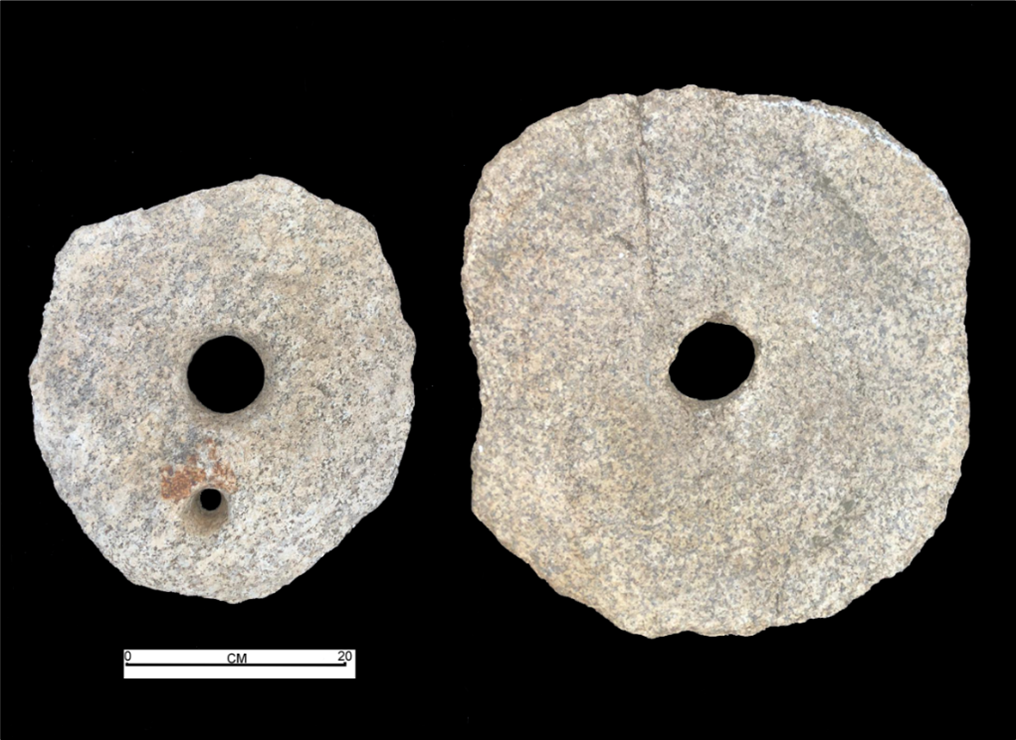
A complete rotary disc quern was recovered in the upper levels of a modern pit in an area of recent disturbance; however, this was not within an archaeological context. The pit contained red brick, wood and some metal and may have been debitage from the farmyard to the east. The quern may have been discarded with 19th-century material from the nearby farm buildings. The farm had gone through significant development in the 19th century when it was converted into a corn mill. As it is a portable object, the original find spot is unknown; items such as this have much curiosity and may have been removed from their original location and can often be used as garden features etc. The quern consisted of two flat disc-shaped stones, an upper stone and a lower stone of granite. The upper stone (measuring 0.39m x 0.38m and 0.09m thick at the center, tapering to c. 0.07m) had a central cylindrical perforation that was slightly funnel-shaped (measuring c. 0.09m in diameter at the top, 55mm deep and reducing to a diameter of 0.07c). It had a funnel-shaped handle hole (measuring 50mm in diameter, reducing to c. 20mm in diameter). The larger lower stone measured 0.42m x 0.38m (with machine damage on one side). It had a central oval-shaped spindle hole (measuring 75mm x 60mm and 90mm thick). It had a rounded base that measured 90-65mm thick; this wedge shape may have assisted in the rotation of the upper stone. The underside of both stones was polished from use with worn circular striations. Rotary disk querns were used in early medieval and late medieval Ireland to grind grain into flour. Despite the arrival of watermills in the early medieval period, disc querns continued to be an essential part of rural life in some parts of Ireland up to the early twentieth century (O’Sullivan & Downey 2006).
The testing confirmed that the geophysical survey showed evidence for 19th-century milling activity, modern disturbance and natural geology. Except for the rotary quern stray find, no features, soils or deposits of archaeological interest were found in any of the trenches opened.
Reference
O’Sullivan, M. & Downey, L. 2006. ‘Quern Stones’ Archaeology Ireland, Vol. 20, No. 2, pp. 22‐25.