2021:348 - KNOCKANARRIGAN, Wicklow
County: Wicklow
Site name: KNOCKANARRIGAN
Sites and Monuments Record No.: N/A
Licence number: Unlicensed Monitoring
Author: Michael Greiner; Shanarc Archaeology Ltd.
Author/Organisation Address: Unit 39a, Hebron Business Park, Hebron Road, Kilkenny
Site type: No archaeology found
Period/Dating: N/A
ITM: E 695834m, N 692908m
Latitude, Longitude (decimal degrees): 52.978345, -6.572982
Unlicensed archaeological monitoring of groundworks associated with the creation of a new forestry road in forestry lands at Knockanarrigan, Co. Wicklow, was carried out from 10th–17th December 2021.
The monitored work was undertaken by Coillte within existing forestry, associated with the development of an approved forest road under Forest Road Licence CN 87694, issued by the Department of Agriculture, Food and the Marine.
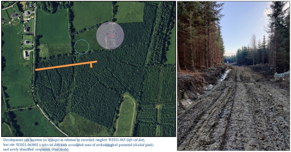
The development site is situated 65m south-west of the Zone of Notification/Zone of Archaeological Potential associated with recorded monuments WI021-063 (ringfort) and WI021-063001 (hut site), and 35m south of a recently identified potential enclosure presenting in the form of a circular cropmark visible on aerial photographs.
The monitored work comprised tree removal, topsoil stripping and ground reductions for the road development along an east-west orientated, c.266m long and c.10m wide corridor through existing forestry, with an additional 30m long branch orientated north-south from the southern edge of the primary development route, approximately 30m from its eastern end. A ditch was also dug along the northern edge of the cleared route to facilitate the drainage of the roadway. Soil was stripped to a maximum depth of 0.6m to formation level of the new road. Topsoil was dark brown and heavily mixed with pine needles, with a general depth of 0.2–0.3m, and occasionally up to 0.6m around trees trunks. Below the topsoil was natural clay varying in colour from yellow to blue-grey; the excavated drainage ditch measured approximately 1m in width, with a depth approximately 0.5–0.6m below the formation level of the roadway.
A number of historic 19th-century field boundary ditches cross the development site, and as they are active drains, they were retained in situ.
No features, deposits or finds of archaeological significance were identified during archaeological monitoring.