2021:127 - BALLYNERRIN & BALLYNERRIN LOWER, Wicklow
County: Wicklow
Site name: BALLYNERRIN & BALLYNERRIN LOWER
Sites and Monuments Record No.: WI025-014
Licence number: 21E0122
Author: Grace Fegan, Shanarc Archaeology Ltd.
Author/Organisation Address: Unit 39a, Hebron Business Park, Hebron Road, Kilkenny
Site type: Cist
Period/Dating: Undetermined
ITM: E 730404m, N 693586m
Latitude, Longitude (decimal degrees): 52.977144, -6.058223
Test-excavations were carried out between 6 April and 4 May 2021 at Ballynerrin Lower, Co. Wicklow, in relation to the proposed third phase of a residential development under planning ref. no. 19/397.
The development site, which contained a recorded monument (cist) WI025-014, and the field immediately to the east which contained the earlier phases of the development project, had been previously subjected to archaeological investigations, comprising a geophysical survey carried out by Target Archaeological Geophysics on behalf of IAC under prospection licence no. 08R127.
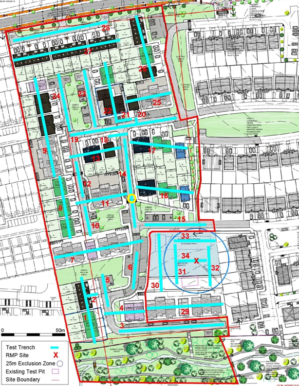
33 targeted test trenches were excavated across the site to address the potential impacts of proposed development on sub-surface archaeological remains. Trenches were 1.8m in width, 4–106m in length and 0.1–0.95m in depth.
Trenches 1–30 targeted a representative sample of the proposed development site, including the locations of potential archaeological features identified during geophysical survey to the west and north-west of cist WI025-014 i.e. trench nos. 2, 18, 20 and 21. The southernmost part of the proposed development site, a sharply sloping and vegetated bank on the Ashtown Stream Valley, was not safely accessible to testing and therefore trench 3 was not excavated.
The general stratigraphy within the test trenches comprised mid-brown sandy clay over yellow sandy natural, with occasional areas of shale bedrock.
Trench 14 was the only trench to produce any archaeological evidence. At the midpoint of the trench a circular feature was identified measuring 1.32m in diam. north-south by 1.25m. The fill of the feature was friable charcoal-rich silty sand. While no artefactual evidence was recovered from the feature, a potential hammerstone or polished stone axehead was recovered during clean-up. The trench was extended to the west to establish the full nature and extent of the feature.
Trenches 31–34 targeted the location of cist WI025-014 and a surrounding 25m buffer. The location of the cist was not identified during geophysical survey, and no anomalies of potential archaeological origin were identified in the surrounding 25m buffer. Within the confines of the cist WI025-014 buffer, test trenches (Nos. 31–34) were partially excavated by hand, as per recommendations made by the National Monuments Service in November 2019. Having commenced hand excavations and established that there was a considerable depth of overburden and introduced material overlying topsoil in much of the area, the National Monuments Service was consulted, and it was agreed that a mechanical excavator could be utilised, under constant archaeological supervision, to remove the overburden until appropriate levels were reached. At this point hand tools were used in order to establish the presence/absence of archaeological material.
The bulk of the trenches (nos. 1–30), outside the confines of the recorded monument, were excavated by a mechanical excavator using a flat grading bucket.